Login
Register


INL
Falls International/Einarson Field Airport
Official FAA Data Effective 2026-02-19 0901Z
Chart Supplement

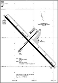
KINL Airport Diagram
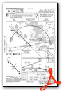
VFR Chart of KINL
Sectional Charts at SkyVector.com
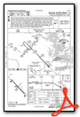
IFR Chart of KINL
Enroute Charts at SkyVector.com
Location Information for KINL
Coordinates: N48°33.94' / W93°24.13'Located 00 miles S of International Falls, Minnesota on 681 acres of land. View all Airports in Minnesota.
Surveyed Elevation is 1184 feet MSL.
Operations Data
|
|
Airport Communications
| ASOS: | 120.0 Tel. 218-210-0035 |
|---|---|
| UNICOM: | 122.800 |
| CTAF: | 122.800 |
| AWOS-3PT at ORB (39.6 SE): | 118.325 218-757-3169 |
| AWOS-3 at CDD (40.8 SE): | 118.2 218-993-2467 |
| AWOS-3PT at FOZ (48.0 S): | 118.025 218-743-3289 |
- APCH/DEP SVC PRVDD BY MINNEAPOLIS ARTCC ON FREQS 120.9/377.1 (INTERNATIONAL FALLS RCAG).
Nearby Navigation Aids
|
| ||||||||||||||||||||||||||||||||||||||||||||||||||||||


Runway 13/31
| Dimensions: | 7400 x 150 feet / 2256 x 46 meters | |
|---|---|---|
| Surface: | Asphalt / Grooved in Excellent Condition 6500 FT OF RWY 13/31 IS GROOVED. SOUTHERN 900 FT OF RWY 13/31 (APCH END RWY 31) IS NOT GROOVED. | |
| Weight Limits: | S-120, D-214, ST-284, DT-759
PCR VALUE: 670/F/D/X/T
| |
| Edge Lighting: | High Intensity | |
| Runway 13 | Runway 31 | |
| Coordinates: | N48°34.37' / W93°24.76' | N48°33.50' / W93°23.48' |
| Elevation: | 1184.4 | 1166.4 |
| Traffic Pattern: | Left | Left |
| Runway Heading: | 136° True | 316° True |
| Declared Distances: | TORA:7400 TODA:7400 ASDA:7400 LDA:7400 | TORA:7400 TODA:7400 ASDA:7400 LDA:7400 |
| Markings: | Precision Instrument in good condition. | Precision Instrument in good condition. |
| Glide Slope Indicator | P4L (3.00° Glide Path Angle) | P4L (3.00° Glide Path Angle) |
| Approach Lights: | MALSR 1,400 Foot Medium-intensity Approach Lighting System with runway alignment indicator lights. | MALSR 1,400 Foot Medium-intensity Approach Lighting System with runway alignment indicator lights. |
Runway 04/22
RWY 04/22 NOT AVBL FOR PART 121/PART 380 OPS WITH SKED PAX CARRYING OPS MORE THAN 9 PAX SEATS AND NON-SKED PAX CARRYING OPS MORE THAN 30 PAX SEATS. CLSD AT NGT. CLSD DRG WINTER MONTHS. | ||
| Dimensions: | 2999 x 75 feet / 914 x 23 meters | |
|---|---|---|
| Surface: | Asphalt in Excellent Condition | |
| Weight Limits: | S-12
PCR VALUE: 100/F/D/X/T
| |
| Runway 04 | Runway 22 | |
| Coordinates: | N48°33.76' / W93°24.40' | N48°34.12' / W93°23.91' |
| Elevation: | 1170.0 | 1181.1 |
| Traffic Pattern: | Left | Left |
| Runway Heading: | 42° True | 222° True |
| Declared Distances: | TORA:2999 TODA:2999 ASDA:2999 LDA:2999 | TORA:2999 TODA:2999 ASDA:2999 LDA:2999 |
| Markings: | Basic in good condition. | Basic in good condition. |
Services Available
| Fuel: | 100LL (blue), Jet-A |
|---|---|
| Transient Storage: | Hangars,Tiedowns |
| Airframe Repair: | NOT AVAILABLE |
| Engine Repair: | NOT AVAILABLE |
| Bottled Oxygen: | NONE |
| Bulk Oxygen: | NONE |
| Other Services: | AIR AMBULANCE SERVICES,CHARTER SERVICE,PILOT INSTRUCTION,AIRCRAFT RENTAL |
Ownership Information
| Ownership: | Publicly owned | |
|---|---|---|
| Owner: | CITY OF INTL FALLS | |
| PO BOX 392 | ||
| INTERNATIONAL FALLS, MN 56649-0392 | ||
| 218-283-4461 | ||
| Manager: | THOR EINARSON | |
| 3214 2ND AVE E | THOR@EINARSONFLYING.COM. | |
| INTERNATIONAL FALLS, MN 56649-8955 | ||
| 218-283-4461 | ||
Other Remarks
- GULLS & DEER ON & INVOF ARPT.
- FOR CD IF UNA TO CTC ON FSS FREQ, CTC MINNEAPOLIS ARTCC AT 651-463-5588.
- FLD CONDS UNMON 0000-0500, CALL 218-283-2712.
- ACTVT MALSR RWY 13 & 31; HIRL RWY 13/31 - CTAF. PAPI RWY 13 & 31 OPR CONSLY.
Weather Minimums


Instrument Approach Procedure (IAP) Charts


Nearby Airports with Instrument Procedures
| ID | Name | Heading / Distance | ||
|---|---|---|---|---|
 |
KORB | Orr Regional Airport | 146° | 39.6 |
|
KFOZ | Bigfork Municipal Airport | 192° | 48.0 |
|
KBDE | Baudette International Airport | 282° | 49.1 |
|
KCQM | Cook Municipal Airport | 147° | 53.0 |
|
12D | Tower Municipal Airport | 134° | 63.4 |
|
KHIB | Range Regional Airport | 162° | 74.3 |
|
KELO | Ely Municipal Airport | 124° | 77.3 |
|
KEVM | Eveleth/Virginia Municipal Airport | 151° | 77.6 |
|
KRRT | Warroad International Memorial Airport | 287° | 80.5 |
|
KGPZ | Grand Rapids/Itasca County-Gordon Newstrom Field Airport | 183° | 81.5 |
|
KBJI | Bemidji Regional Airport | 224° | 88.4 |
|
KROX | Roseau Municipal/Rudy Billberg Field Airport | 281° | 92.8 |
Airport Images
Do you have a recent image of this airport? Upload it here!


