Login
Register


1S9
Chewelah Municipal Airport
Official FAA Data Effective 2026-02-19 0901Z
Chart Supplement

VFR Chart of 1S9
Sectional Charts at SkyVector.com
IFR Chart of 1S9
Enroute Charts at SkyVector.com
Location Information for 1S9
Coordinates: N48°18.84' / W117°44.61'View all Airports in Washington, United States.
Estimated Elevation is 2084 feet MSL.
Operations Data
|
|
Airport Communications
| CTAF: | 122.900 |
|---|---|
| AWOS-3 at 63S (14.8 N): | 119.275 509-684-8994 |
| ASOS at DEW (24.0 SE): | 135.175 509-276-2303 |
| ASOS at SFF (41.4 SE): | 120.55 509-535-3290 |
Nearby Navigation Aids
|
| ||||||||||||||||||||||||||||||||||||||||||||||||


Runway 17/35
| Dimensions: | 3537 x 48 feet / 1078 x 15 meters | |
|---|---|---|
| Surface: | Asphalt in Excellent Condition | |
| Edge Lighting: | Medium Intensity | |
| Runway 17 | Runway 35 | |
| Coordinates: | N48°19.12' / W117°44.53' | N48°18.55' / W117°44.68' |
| Traffic Pattern: | Right | |
| Displaced Threshold: | 230 Feet | 87 Feet |
| Markings: | Basic in good condition. | Basic in good condition. |
| Glide Slope Indicator | P2R (4.00° Glide Path Angle) | P2L (3.00° Glide Path Angle) |
| Obstacles: | 31 ft Tree 270 ft from runway, 10 ft left of center RWY 17 APCH SLOPE 50:1 TO DSPLCD THR. 3 FT DITCH +1 FT TO +3 FT ROCKS & RD 56 FT FM THR; 77 FT L, +14 FT TREES 200 FT FM THR, AND 10 FT SIGN, 86 FT R, 53 FT FM THR. |
|
Services Available
| Fuel: | 100LL (blue), Jet-A |
|---|---|
| Transient Storage: | Tiedowns PILOTS BRING OWN ROPES. |
| Airframe Repair: | MINOR |
| Engine Repair: | MINOR |
| Bottled Oxygen: | NONE |
| Bulk Oxygen: | NONE |
Ownership Information
| Ownership: | Publicly owned | |
|---|---|---|
| Owner: | CITY OF CHEWELAH | |
| PO BOX 258 | ||
| CHEWELAH, WA 99109 | ||
| 509-935-8311 | ||
| Manager: | TYRONE BRYANT | |
| 139 RICHMOND LANE | ||
| CHEWELAH, WA 99109 | ||
| (509) 936-0234 | ||
Other Remarks
- ALL PATTERNS TO THE WEST.
- DEER & WILDLIFE ON & INVOF ARPT.
- FOR CD CTC SEATTLE ARTCC AT 253-351-3694.
- LODGING & FOOD AVBL AT APRT.
- 0LL 100LL & JET A AVBL 24 HRS CREDIT CARD SELF SVC.
- ACTVT MIRL RY 17/35 - CTAF. PAPI RY 17 AND RY 35 OPER CONTINUOUSLY.
Nearby Airports with Instrument Procedures
| ID | Name | Heading / Distance | ||
|---|---|---|---|---|
 |
KDEW | Deer Park Airport | 148° | 24.4 |
|
KSFF | Felts Field Airport | 155° | 41.5 |
|
KSKA | Fairchild AFB Airport | 175° | 42.1 |
|
KGEG | Spokane International Airport | 168° | 42.6 |
|
KSZT | Sandpoint Airport | 090° | 47.4 |
|
KCOE | Coeur D'Alene/Pappy Boyington Field Airport | 130° | 49.3 |
|
2S8 | Wilbur Airport | 230° | 52.5 |
|
65S | Boundary County Airport | 066° | 62.8 |
|
KOMK | Omak Airport | 277° | 71.5 |
|
S59 | Libby Airport | 090° | 90.3 |
|
KMWH | Grant County International Airport | 224° | 92.0 |
|
KEPH | Ephrata Municipal Airport | 230° | 93.8 |
Airport Images
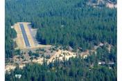
By: davegilbert


Comments
They have fuel now.
$7.70 per gal.