Login
Register


20U
Beach Airport
Official FAA Data Effective 2026-01-22 0901Z
Chart Supplement

VFR Chart of 20U
Sectional Charts at SkyVector.com
IFR Chart of 20U
Enroute Charts at SkyVector.com
Location Information for 20U
Coordinates: N46°55.51' / W103°58.92'Located 01 miles ENE of Beach, North Dakota on 175 acres of land. View all Airports in North Dakota.
Surveyed Elevation is 2755 feet MSL.
Operations Data
|
|
Airport Communications
| AWOS-3: | 118.175 Tel. 701-872-9225 |
|---|---|
| UNICOM: | 122.800 |
| CTAF: | 122.800 |
| AWOS-3PT at GDV (36.1 W): | 135.075 406-687-3346 |
| ASOS at BHK (36.5 S): | 135.475 406-778-3312 |
| AWOS-3PT at SDY (47.5 N): | 119.275 406-482-7323 |
- APCH/DEP CTL SVC PRVDD BY SALT LAKE ARTCC (ZLC) 126.85/305.2 (WATFORD CITY RCAG).
Nearby Navigation Aids
|
| ||||||||||||||||||||||||||||||


Runway 12/30
| Dimensions: | 4200 x 60 feet / 1280 x 18 meters | |
|---|---|---|
| Surface: | Asphalt in Good Condition | |
| Weight Limits: | S-12 | |
| Edge Lighting: | Medium Intensity | |
| Runway 12 | Runway 30 | |
| Coordinates: | N46°55.75' / W103°59.29' | N46°55.27' / W103°58.56' |
| Elevation: | 2755.9 | 2748.3 |
| Traffic Pattern: | Left | Left |
| Runway Heading: | 133° True | 313° True |
| Markings: | Non-Precision Instrument in good condition. | Non-Precision Instrument in good condition. |
| Glide Slope Indicator | P2L (3.00° Glide Path Angle) | P2L (3.00° Glide Path Angle) |
Services Available
| Fuel: | 100LL (blue), Jet-A |
|---|---|
| Transient Storage: | Tiedowns |
| Airframe Repair: | NONE |
| Engine Repair: | NONE |
| Bottled Oxygen: | NONE |
| Bulk Oxygen: | NONE |
Ownership Information
| Ownership: | Publicly owned | |
|---|---|---|
| Owner: | GOLDEN VALLEY CO ARPT AUTH. | |
| P.O. BOX 748 | ||
| BEACH, ND 58621 | ||
| 256-496-1978 | AMGR - KARL DAVIS | |
| Manager: | KARL DAVIS | IF AMGR NOT AVBL CALL GERRI WEINREIS 701-872-3414. |
| P.O. BOX 748 | ||
| BEACH, ND 58621 | ||
| (256) 496-1978 | ||
Other Remarks
- CFM SNOW REMOVAL AFT MAJOR WINTER STORM 256-496-1978.
- BIRDS & DEER ON & INVOF ARPT.
- FOR CD CTC SALT LAKE ARTCC AT 801-320-2568.
- AFT HRS CALL 256-496-1978.
- AFT HRS CALL 256-496-1978.
- 0LL SELF SVC AVBL H24 VIA CREDIT CARD.
- ACTVT PAPI RWY 12 & 30; MIRL RWY 12/30 - CTAF.
- UNICOM UNATNDD.
Weather Minimums

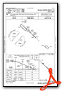
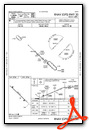
Instrument Approach Procedure (IAP) Charts
Nearby Airports with Instrument Procedures
| ID | Name | Heading / Distance | ||
|---|---|---|---|---|
 |
KGDV | Dawson Community Airport | 291° | 36.2 |
|
KBHK | Baker Municipal Airport | 198° | 36.6 |
|
KSDY | Sidney-Richland Regional Airport | 349° | 47.7 |
|
KDIK | Dickinson/Theodore Roosevelt Regional Airport | 098° | 49.1 |
|
KBWW | Bowman Regional Airport | 148° | 53.6 |
|
9Y1 | Dunn County Weydahl Field Airport | 060° | 56.9 |
|
S25 | Watford City Municipal Airport | 029° | 60.1 |
|
97M | Ekalaka Airport | 200° | 67.0 |
|
4U6 | Circle Town County Airport | 295° | 71.1 |
|
3P3 | Mott Municipal Airport | 115° | 76.3 |
|
KHEI | Hettinger/Jb Lindquist Regional Airport | 134° | 77.5 |
|
KXWA | Williston Basin International Airport | 006° | 80.7 |
Airport Images
Do you have a recent image of this airport? Upload it here!


