Login
Register


SDY
Sidney-Richland Regional Airport
Official FAA Data Effective 2025-11-27 0901Z
Chart Supplement

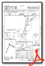
KSDY Airport Diagram

VFR Chart of KSDY
Sectional Charts at SkyVector.com
IFR Chart of KSDY
Enroute Charts at SkyVector.com
Location Information for KSDY
Coordinates: N47°42.41' / W104°11.55'Located 01 miles W of Sidney, Montana on 335 acres of land. View all Airports in Montana.
Surveyed Elevation is 1985 feet MSL.
Operations Data
|
|
Airport Communications
| AWOS-3PT: | 119.275 Tel. 406-482-7323 |
|---|---|
| CTAF: | 122.800 |
| UNICOM: | 122.800 |
| AWOS-3 at S85 (29.4 NW): | 120.000 406-787-5819 |
| ASOS at XWA (37.4 NE): | 125.925 701-289-3089 |
| AWOS-3PT at S25 (38.2 E): | 118.125 701-842-4855 |
- COMMUNICATIONS PRVDD BY GREAT FALLS RADIO ON FREQ 122.3 (SIDNEY RCO).
- APCH/DEP CTL SVC PRVDD BY SALT LAKE ARTCC (ZLC) ON 126.85/305.2 (WATFORD CITY RCAG).
Nearby Navigation Aids
|
| ||||||||||||||||||||||||||||||


Runway 01/19
| Dimensions: | 5705 x 100 feet / 1739 x 30 meters | |
|---|---|---|
| Surface: | Asphalt / Grooved in Good Condition | |
| Weight Limits: | S-46, D-62, ST-108
PCR VALUE: 180/F/D/Y/T
| |
| Edge Lighting: | Medium Intensity | |
| Runway 01 | Runway 19 | |
| Coordinates: | N47°41.86' / W104°12.07' | N47°42.72' / W104°11.51' |
| Elevation: | 1982.6 | 1980.6 |
| Traffic Pattern: | Left | Right |
| Runway Heading: | 24° True | 204° True |
| Declared Distances: | TORA:5705 TODA:5705 ASDA:5705 LDA:5705 | TORA:5705 TODA:5705 ASDA:5705 LDA:5705 |
| Markings: | Non-Precision Instrument in good condition. | Non-Precision Instrument in good condition. |
| Glide Slope Indicator | P2L (3.00° Glide Path Angle) | P2L (3.00° Glide Path Angle) |
| REIL: | Yes | Yes |
| Obstacles: | 29 ft Tree 956 ft from runway | |
Runway 11/29
| Dimensions: | 4024 x 100 feet / 1227 x 30 meters | |
|---|---|---|
| Surface: | Asphalt / Grooved in Good Condition | |
| Weight Limits: | S-54, D-70, ST-119
PCR VALUE: 211/F/D/Y/T
| |
| Edge Lighting: | Medium Intensity | |
| Runway 11 | Runway 29 | |
| Coordinates: | N47°42.74' / W104°11.66' | N47°42.44' / W104°10.79' |
| Elevation: | 1980.6 | 1966.4 |
| Traffic Pattern: | Right | Left |
| Runway Heading: | 117° True | 297° True |
| Declared Distances: | TORA:4023 TODA:4023 ASDA:4023 LDA:4023 | TORA:4023 TODA:4023 ASDA:4023 LDA:4023 |
| Markings: | Basic in good condition. | Basic in good condition. |
| Glide Slope Indicator | P2L (3.00° Glide Path Angle) | P2L (3.00° Glide Path Angle) |
| REIL: | Yes | Yes |
| Obstacles: | 14 ft Road 489 ft from runway | 10 ft Road 489 ft from runway |
Services Available
| Fuel: | 100LL (blue), Jet-A |
|---|---|
| Transient Storage: | Hangars,Tiedowns |
| Airframe Repair: | MAJOR |
| Engine Repair: | MAJOR |
| Bottled Oxygen: | HIGH |
| Bulk Oxygen: | NONE |
| Other Services: | AIR FREIGHT SERVICES,CROP DUSTING SERVICES,CARGO HANDLING SERVICES,CHARTER SERVICE,PILOT INSTRUCTION,AIRCRAFT RENTAL,AIRCRAFT SALES |
Ownership Information
| Ownership: | Publicly owned | |
|---|---|---|
| Owner: | SIDNEY RICHLAND APT AUTHORITY | |
| PO BOX 1050, 540 AIRPORT ROAD | ||
| SIDNEY, MT 59270 | ||
| 406-480-1820 | ||
| Manager: | RYAN HUOTARI | |
| 540 AIRPORT ROAD, P.O. BOX 1050 | ||
| SIDNEY, MT 59270 | ||
| (406) 480-1820 | OR 406-480-1820 | |
Other Remarks
- FOR ARPT CONDITIONS, CTC ARPT MGT - 406-480-1820. SFC CONDITIONS UNMONITORED 0400-1300Z++
- FLOCKS OF WATER FOWL IN VICINITY OF ARPT.
- FOR CD IF UNA TO CTC ON FSS FREQ, CTC SALT LAKE ARTCC AT 801-320-2568.
- ACTVT MIRL RYS 01/19 & 11/29; REIL RYS 01 & 19, 11 & 29; PAPI RYS 01 & 19, 11 & 29 - CTAF.
Weather Minimums

Instrument Approach Procedure (IAP) Charts

Nearby Airports with Instrument Procedures
| ID | Name | Heading / Distance | ||
|---|---|---|---|---|
 |
KXWA | Williston Basin International Airport | 028° | 37.7 |
|
S25 | Watford City Municipal Airport | 081° | 38.5 |
|
KGDV | Dawson Community Airport | 216° | 42.3 |
|
PO1 | Poplar Municipal Airport | 303° | 46.8 |
|
20U | Beach Airport | 169° | 47.7 |
|
4U6 | Circle Town County Airport | 253° | 58.2 |
|
KOLF | L M Clayton Airport | 293° | 60.5 |
|
9Y1 | Dunn County Weydahl Field Airport | 107° | 60.8 |
|
D60 | Tioga Municipal Airport | 051° | 66.0 |
|
KPWD | Sher-Wood Airport | 348° | 66.4 |
|
05D | New Town Municipal Airport | 076° | 71.0 |
|
KDIK | Dickinson/Theodore Roosevelt Regional Airport | 133° | 78.6 |
Fuel Providers

Airport Images
Do you have a recent image of this airport? Upload it here!


