Login
Register


XWA
Williston Basin International Airport
Official FAA Data Effective 2026-02-19 0901Z
Chart Supplement

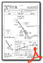
KXWA Airport Diagram

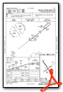
VFR Chart of KXWA
Sectional Charts at SkyVector.com
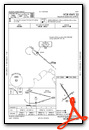
IFR Chart of KXWA
Enroute Charts at SkyVector.com
Location Information for KXWA
Coordinates: N48°15.59' / W103°45.03'Located 09 miles NW of Williston, North Dakota on 1600 acres of land. View all Airports in North Dakota.
Surveyed Elevation is 2356 feet MSL.
Operations Data
|
|
Airport Communications
| ASOS: | 125.925 Tel. 701-289-3089 |
|---|---|
| CTAF: | 122.800 |
| UNICOM: | 122.800 |
| AWOS-3 at S85 (30.6 W): | 120.000 406-787-5819 |
| AWOS-3PT at S25 (34.3 SE): | 118.125 701-842-4855 |
| AWOS-3 at D60 (34.8 E): | 118.575 701-664-4490 |
- APCH/DEP CTL SVC PRVDD BY SALT LAKE CITY ARTCC ON FREQS 126.85/305.2 (WATFORD CITY RCAG).
- COMMUNICATIONS PRVDD BY GRAND FORKS RADIO ON FREQ 122.5 (WILLISTON RCO).
Nearby Navigation Aids
|
| ||||||||||||||||||

Runway 14/32
| Dimensions: | 7503 x 150 feet / 2287 x 46 meters | |
|---|---|---|
| Surface: | Concrete / Grooved in Excellent Condition | |
| Weight Limits: | S-120, D-195, ST-339
PCR VALUE: 622/R/D/W/T
| |
| Edge Lighting: | High Intensity | |
| Runway 14 | Runway 32 | |
| Coordinates: | N48°16.17' / W103°45.56' | N48°15.13' / W103°44.58' |
| Elevation: | 2302.9 | 2349.9 |
| Runway Heading: | 148° True | 328° True |
| Declared Distances: | TORA:7503 TODA:7503 ASDA:7503 LDA:7503 | TORA:7503 TODA:7503 ASDA:7503 LDA:7503 |
| Markings: | Non-Precision Instrument in good condition. | Precision Instrument in good condition. |
| Glide Slope Indicator | P4L (3.00° Glide Path Angle) | P4L (3.00° Glide Path Angle) |
| Approach Lights: | MALSR 1,400 Foot Medium-intensity Approach Lighting System with runway alignment indicator lights. | |
| REIL: | Yes | |
Runway 04/22
RWY 04/22 NOT AVBL FOR PART 121/PART 380 OPS WITH SKED PAX CARRYING OPS MORE THAN 9 PAX SEATS AND NON-SKED PAX CARRYING OPS MORE THAN 30 PAX SEATS. | ||
| Dimensions: | 4502 x 75 feet / 1372 x 23 meters | |
|---|---|---|
| Surface: | Concrete / Grooved in Excellent Condition | |
| Weight Limits: | S-12
PCR VALUE: 148/R/D/W/T
| |
| Edge Lighting: | Medium Intensity | |
| Runway 04 | Runway 22 | |
| Coordinates: | N48°15.25' / W103°45.41' | N48°15.70' / W103°44.54' |
| Elevation: | 2356.0 | 2317.9 |
| Runway Heading: | 52° True | 232° True |
| Declared Distances: | TORA:4502 TODA:4502 ASDA:4502 LDA:4502 | TORA:4502 TODA:4502 ASDA:4502 LDA:4502 |
| Markings: | Non-Precision Instrument in good condition. | Non-Precision Instrument in good condition. |
| Glide Slope Indicator | P2L (3.00° Glide Path Angle) | P2L (3.00° Glide Path Angle) |
| REIL: | Yes | Yes |
Services Available
| Fuel: | 100LL (blue), Jet-A |
|---|---|
| Transient Storage: | Hangars,Tiedowns |
| Airframe Repair: | MAJOR |
| Engine Repair: | MAJOR |
| Bottled Oxygen: | NONE |
| Bulk Oxygen: | HIGH |
| Other Services: | AIR FREIGHT SERVICES,CROP DUSTING SERVICES,AIR AMBULANCE SERVICES,CARGO HANDLING SERVICES,CHARTER SERVICE,PILOT INSTRUCTION,AIRCRAFT RENTAL,ANNUAL SURVEYING |
Ownership Information
| Ownership: | Publicly owned | |
|---|---|---|
| Owner: | CITY OF WILLISTON | |
| PO BOX 1306 | ||
| WILLISTON, ND 58802 | ||
| 701-577-8100 | ||
| Manager: | ANTHONY DUDAS | |
| 14127 JENSEN LANE, SUITE 200 | ||
| WILLISTON, ND 58801 | ||
| 701-580-5699 | ||
Other Remarks
- BIRDS & DEER ON & INVOF ARPT.
- ARPT SFC CONDS UNMON 0100-0500 DAILY.
- FOR US CUSTOMS CALL 701-875-2128.
- 0LL FOR AFT HRS FUEL, CTC 701-570-5345
- ACTVT MALSR RWY 32; REIL RWY 04, 14, & 22; MIRL RWY 04/22; HIRL RWY 14/32 - CTAF. HIRL RWY 14/32 OPRNL ON LOW INTST, TO INCR INTST - CTAF. PAPI RWYS 4, 14, 22 & 32 OPR CONSLY.
Weather Minimums


Instrument Approach Procedure (IAP) Charts


Departure Procedure (DP) Charts

Nearby Airports with Instrument Procedures
| ID | Name | Heading / Distance | ||
|---|---|---|---|---|
 |
S25 | Watford City Municipal Airport | 144° | 34.5 |
|
D60 | Tioga Municipal Airport | 077° | 34.9 |
|
KSDY | Sidney-Richland Regional Airport | 208° | 37.7 |
|
D50 | Crosby Municipal Airport | 024° | 44.0 |
|
KPWD | Sher-Wood Airport | 316° | 44.3 |
|
08D | Stanley Municipal Airport | 086° | 53.9 |
|
05D | New Town Municipal Airport | 108° | 54.1 |
|
PO1 | Poplar Municipal Airport | 262° | 57.2 |
|
9Y1 | Dunn County Weydahl Field Airport | 142° | 65.5 |
|
7K5 | Kenmare Municipal Airport | 069° | 72.3 |
|
KOLF | L M Clayton Airport | 262° | 73.9 |
|
9S2 | Scobey Airport | 296° | 75.0 |
Airport Images
Do you have a recent image of this airport? Upload it here!


