Login
Register


2IS
Airglades Airport
Official FAA Data Effective 2026-01-22 0901Z
Chart Supplement

VFR Chart of 2IS
Sectional Charts at SkyVector.com
IFR Chart of 2IS
Enroute Charts at SkyVector.com
Location Information for 2IS
Coordinates: N26°44.11' / W81°3.06'Located 05 miles W of Clewiston, Florida on 2560 acres of land. View all Airports in Florida.
Surveyed Elevation is 20 feet MSL.
Operations Data
|
|
Airport Communications
| AWOS-3PT: | 124.175 Tel. 863-983-7020 |
|---|---|
| UNICOM: | 123.050 |
| CTAF: | 123.050 |
| AWOS-3 at IMM (26.4 SW): | 118.525 239-657-2038 |
| AWOS-3 at OBE (33.7 N): | 118.675 863-467-1148 |
| D-ATIS at RSW (39.6 W): | 124.65 |
- APCH/DEP SVC PRVDD BY MIAMA ARTCC ON FREQS 132.45/307.1 (PAHOKEE RCAG).
Nearby Navigation Aids
|
| ||||||||||||||||||||||||||||||||||||||||||||||||


Runway 13/31
| Dimensions: | 5902 x 75 feet / 1799 x 23 meters | |
|---|---|---|
| Surface: | Asphalt in Good Condition | |
| Weight Limits: | 28 /F/A/X/T, S-79, D-116 | |
| Edge Lighting: | Medium Intensity | |
| Runway 13 | Runway 31 | |
| Coordinates: | N26°44.45' / W81°3.45' | N26°43.77' / W81°2.68' |
| Elevation: | 19.4 | 19.3 |
| Traffic Pattern: | Right | Left |
| Runway Heading: | 135° True | 315° True |
| Markings: | Non-Precision Instrument in fair condition. | Non-Precision Instrument in fair condition. |
| Obstacles: | 41 ft Tree 1855 ft from runway, 185 ft right of center | |
Services Available
| Fuel: | 100LL (blue), Jet-A |
|---|---|
| Transient Storage: | Tiedowns |
| Airframe Repair: | MINOR |
| Engine Repair: | MINOR |
| Bottled Oxygen: | NONE |
| Bulk Oxygen: | NONE |
| Other Services: | CROP DUSTING SERVICES,PILOT INSTRUCTION,PARACHUTE JUMP ACTIVITY,AIRCRAFT RENTAL,AIRCRAFT SALES |
Ownership Information
| Ownership: | Publicly owned | |
|---|---|---|
| Owner: | HENDRY COUNTY | JENNIFER DAVIS 863-675-5220. |
| P.O. BOX 1607, 99 EAST COWBOY WAY | ||
| LABELLE, FL 33975-1607 | ||
| 863-675-5329 | ||
| Manager: | ERIKA ALMANZA | 863-983-6151 |
| 1090 AIRGLADES BLVD, SUITE 200 | ||
| CLEWISTON, FL 33440 | ||
| 863-656-4066 | ||
Other Remarks
- FOR CD CTC MIAMI ARTCC AT 305-716-1731.
- 0LL SELF SVC.
- SELF SVC.
- ACTVT MIRL RWY 13/31 - CTAF.
Weather Minimums

Instrument Approach Procedure (IAP) Charts
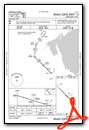
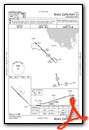
Nearby Airports with Instrument Procedures
| ID | Name | Heading / Distance | ||
|---|---|---|---|---|
 |
KPHK | Palm Beach County Glades Airport | 081° | 19.4 |
|
X14 | La Belle Municipal Airport | 271° | 20.3 |
|
KIMM | Immokalee Regional Airport | 226° | 26.0 |
|
KOBE | Okeechobee County Airport | 018° | 33.6 |
|
KRSW | Southwest Florida International Airport | 252° | 39.7 |
|
06FA | William P Gwinn Airport | 074° | 40.1 |
|
KFMY | Page Field Airport | 258° | 44.6 |
|
F45 | North Palm Beach County General Aviation Airport | 081° | 45.0 |
|
KSEF | Sebring Regional Airport | 340° | 45.9 |
|
X06 | Arcadia Municipal Airport | 303° | 50.4 |
|
KPBI | Palm Beach International Airport | 093° | 51.4 |
|
KPGD | Punta Gorda Airport | 282° | 51.6 |
Airport Images

By: val.foreit


