Login
Register


PHK
Palm Beach County Glades Airport
Official FAA Data Effective 2025-12-25 0901Z
Chart Supplement

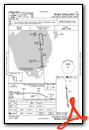
VFR Chart of KPHK
Sectional Charts at SkyVector.com
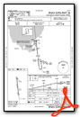
IFR Chart of KPHK
Enroute Charts at SkyVector.com
Location Information for KPHK
Coordinates: N26°47.10' / W80°41.60'Located 03 miles SW of Pahokee, Florida on 243 acres of land. View all Airports in Florida.
Surveyed Elevation is 15 feet MSL.
Operations Data
|
|
Airport Communications
| PALM BEACH APPROACH: | 125.2 317.4 |
|---|---|
| PALM BEACH DEPARTURE: | 125.2 317.4 |
| UNICOM: | 122.800 |
| CTAF: | 122.800 |
| AWOS-3PT at 2IS (19.5 W): | 124.175 863-983-7020 |
| AWOS-3 at F45 (25.5 E): | 119.975 561-630-6932 |
| AWOS-3 at OBE (30.1 N): | 118.675 863-467-1148 |
Nearby Navigation Aids
|
| ||||||||||||||||||||||||||||||||||||||||||||||||||||||


Runway 18/36
| Dimensions: | 4116 x 75 feet / 1255 x 23 meters | |
|---|---|---|
| Surface: | Asphalt in Excellent Condition | |
| Weight Limits: | 13 /F/B/X/T, S-20 | |
| Edge Lighting: | Medium Intensity | |
| Runway 18 | Runway 36 | |
| Coordinates: | N26°47.44' / W80°41.64' | N26°46.76' / W80°41.56' |
| Elevation: | 15.3 | 15.6 |
| Traffic Pattern: | Left | Left |
| Runway Heading: | 174° True | 354° True |
| Displaced Threshold: | 100 Feet | 52 Feet |
| Declared Distances: | TORA:4069 TODA:4069 ASDA:4119 LDA:4016 | TORA:4016 TODA:4016 ASDA:4170 LDA:4069 |
| Markings: | Non-Precision Instrument in good condition. | Non-Precision Instrument in good condition. |
| Glide Slope Indicator | P2L (3.00° Glide Path Angle) | P2L (3.00° Glide Path Angle) |
| REIL: | Yes | Yes |
| Obstacles: | 40 ft Trees 1050 ft from runway, 150 ft right of center RY 18 APCH RATIO 28:1 AT DSPLCD THLD. |
27 ft Trees 885 ft from runway, 10 ft right of center RY 36 APCH RATIO 35:1 AT DSPLCD THLD. |
Services Available
| Fuel: | 100LL (blue), Jet-A |
|---|---|
| Transient Storage: | Hangars,Tiedowns |
| Airframe Repair: | NONE |
| Engine Repair: | NONE |
| Bottled Oxygen: | NONE |
| Bulk Oxygen: | NONE |
| Other Services: | PARACHUTE JUMP ACTIVITY |
Ownership Information
| Ownership: | Publicly owned | |
|---|---|---|
| Owner: | PALM BEACH COUNTY | |
| DEPARTMENT OF AIRPORTS, 846 PBIA | ||
| WEST PALM BEACH, FL 33406-1491 | ||
| 561-471-7420 | ||
| Manager: | LAURA BEEBE | |
| 846 PALM BEACH INTL AIRPORT | ||
| WEST PALM BEACH, FL 33406-1470 | ||
| 561-471-7420 | ||
Other Remarks
- THIS AIRPORT HAS BEEN SURVEYED BY THE NATIONAL GEODETIC SURVEY.
- BIRDS ON AND INVOF ARPT.
- ARPT SFC COND NOT RPRTD FOR ALL RWYS.
- FOR CD IF UNA TO CTC ON FSS FREQ, CTC PALM BEACH APCH AT 561-275-1430 OR 561-684-9047.
- FBO SVC FEE MAY APPLY.
- 24-HR PPR RQ FOR ALL ACFT EQUIPPED WITH WX MODIFICATION EQPT OR ACFT CPBL OF WX MODIFICATION AND/OR GEOENGINEERING BY CTC THE DEPT OF ARPT COMMUNICATIONS CNTR AT (561) 471-7420..
- ACTVT MIRL RWY 18/36 - CTAF.
Weather Minimums
Instrument Approach Procedure (IAP) Charts
Nearby Airports with Instrument Procedures
| ID | Name | Heading / Distance | ||
|---|---|---|---|---|
 |
2IS | Airglades Airport | 261° | 19.4 |
|
06FA | William P Gwinn Airport | 069° | 20.9 |
|
F45 | North Palm Beach County General Aviation Airport | 081° | 25.5 |
|
KOBE | Okeechobee County Airport | 343° | 30.0 |
|
KPBI | Palm Beach International Airport | 100° | 32.7 |
|
KLNA | Palm Beach County Park Airport | 109° | 34.6 |
|
KSUA | Witham Field Airport | 046° | 34.7 |
|
X14 | La Belle Municipal Airport | 266° | 39.6 |
|
KBCT | Boca Raton Airport | 127° | 39.8 |
|
KIMM | Immokalee Regional Airport | 241° | 43.4 |
|
KPMP | Pompano Beach Airpark Airport | 135° | 44.9 |
|
KFXE | Fort Lauderdale Exec Airport | 141° | 45.0 |
Airport Images

By: toledoceduardo


