Login
Register


F45
North Palm Beach County General Aviation Airport
Official FAA Data Effective 2025-11-27 0901Z
Chart Supplement

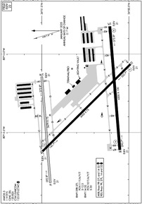
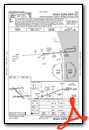
Airport Diagram
VFR Chart of F45
Sectional Charts at SkyVector.com
IFR Chart of F45
Enroute Charts at SkyVector.com
Location Information for F45
Coordinates: N26°50.76' / W80°13.34'Located 12 miles NW of West Palm Beach, Florida on 1832 acres of land. View all Airports in Florida.
Surveyed Elevation is 22 feet MSL.
Operations Data
|
|
Airport Communications
| AWOS-3: | 119.975 Tel. 561-630-6932 |
|---|---|
| PALM BEACH APPROACH: | 128.3 317.4 |
| PALM BEACH DEPARTURE: | 128.3 317.4 |
| CLEARANCE DELIVERY: | 120.825 |
| VUUDU STAR: | 127.35 317.4 |
| CLMNT STAR: | 124.6 317.4 |
| CTAF: | 123.075 |
| JESTR STAR: | 124.6 317.4 |
| UNICOM: | 123.075 |
| TTYLR STAR: | 125.2 317.4 |
| ASOS at PBI (11.7 SE): | 123.75 561-683-2548 |
| D-ATIS at PBI (11.9 SE): | 123.75 |
| AWOS-3PT at LNA (16.9 SE): | 119.925 561-964-0308 |
Nearby Navigation Aids
|
| ||||||||||||||||||||||||||||||||||||||||||||||||||||||


Runway 09R/27L
ACFT OVER 12500 LBS GWT NA. | ||
| Dimensions: | 4300 x 100 feet / 1311 x 30 meters | |
|---|---|---|
| Surface: | Asphalt in Fair Condition | |
| Weight Limits: | 11 /F/A/Y/T, S-12 | |
| Edge Lighting: | Medium Intensity | |
| Runway 09R | Runway 27L | |
| Coordinates: | N26°50.55' / W80°13.61' | N26°50.61' / W80°12.82' |
| Elevation: | 21.3 | 21.3 |
| Traffic Pattern: | Right | |
| Runway Heading: | 85° True | 265° True |
| Markings: | Precision Instrument in good condition. | Non-Precision Instrument in good condition. |
| Glide Slope Indicator | P2L (3.00° Glide Path Angle) | P2L (3.00° Glide Path Angle) |
| REIL: | Yes | Yes |
| Obstacles: | 75 ft Tree 2820 ft from runway, 75 ft right of center | |
Runway 14/32
ACFT OVER 30000 LBS NA. | ||
| Dimensions: | 4300 x 75 feet / 1311 x 23 meters | |
|---|---|---|
| Surface: | Asphalt in Fair Condition | |
| Weight Limits: | 10 /F/A/Y/T, S-30 | |
| Edge Lighting: | Medium Intensity | |
| Runway 14 | Runway 32 | |
| Coordinates: | N26°51.00' / W80°13.62' | N26°50.49' / W80°13.06' |
| Elevation: | 21.3 | 21.2 |
| Traffic Pattern: | Right | |
| Runway Heading: | 135° True | 315° True |
| Markings: | Non-Precision Instrument in fair condition. | Non-Precision Instrument in fair condition. |
| Glide Slope Indicator | P2L (3.00° Glide Path Angle) | P2L (3.00° Glide Path Angle) |
| REIL: | Yes | Yes |
| Obstacles: | 51 ft Trees 2065 ft from runway, 115 ft left of center | 33 ft Trees 910 ft from runway, 185 ft left of center |
Runway 09L/27R
| Dimensions: | 3679 x 75 feet / 1121 x 23 meters | |
|---|---|---|
| Surface: | Turf in Good Condition | |
| Runway 09L | Runway 27R | |
| Coordinates: | N26°50.95' / W80°13.82' | N26°51.00' / W80°13.14' |
| Elevation: | 20.8 | 20.8 |
| Traffic Pattern: | Right | |
| Runway Heading: | 85° True | 265° True |
| Markings: | Non-Standard in good condition. | Non-Standard in good condition. |
| Obstacles: | 67 ft Tree 1655 ft from runway, 65 ft right of center | 67 ft Tree 1560 ft from runway, 45 ft right of center |
Services Available
| Fuel: | 100LL (blue), Jet-A |
|---|---|
| Transient Storage: | Hangars,Tiedowns |
| Airframe Repair: | MAJOR |
| Engine Repair: | MAJOR |
| Bottled Oxygen: | NOT AVAILABLE |
| Bulk Oxygen: | NOT AVAILABLE |
| Other Services: | AVIONICS,CHARTER SERVICE,PILOT INSTRUCTION,AIRCRAFT RENTAL,AIRCRAFT SALES |
Ownership Information
| Ownership: | Publicly owned | |
|---|---|---|
| Owner: | PALM BEACH COUNTY | |
| DEPARTMENT OF AIRPORTS, 846 PBIA | ||
| WEST PALM BEACH, FL 33406-1470 | ||
| 561-471-7404 | ||
| Manager: | LAURA BEEBE | |
| 846 PALM BEACH INTL AIRPORT | ||
| WEST PALM BEACH, FL 33406-1470 | ||
| 561-471-7420 | 561-626-9771 | |
Other Remarks
- NOISE ABATEMENT PROC; RWY 14/32 PREFERRED NGT RWY; H24 NOISE ABATEMENT MNTG - (561) 626-7631.
- ARPT SFC COND NOT RPRTD FOR ALL RWYS.
- FOR CD CTC PALM BEACH APCH AT 561-684-9047.
- FBO SVC FEE MAY APPLY.
- RWY 9R TDZ MRKGS NOT STD.
- 24-HR PPR REQSTD FOR ALL ACFT EQUIPPED WITH WEATHER MODIFICATION EQPT OR ACFT CPBL OF WEATHER MODIFICATION AND/OR GEOENGINEERING BY CTC THE DEPT OF ARPT COMMUNICATIONS CNTR AT (561) 471-7420.
- BIRD ACT INVOF ARPT.
- EXTSV FLT TRNG MULT RWYS. PRACTICE APCH RWY 9R/27L MNT CTAF & YIELD TO TFC PAT.
- TWY G1 CLSD.
- PVC PIPE EV 200 FT.
- THR MKR 4 FT BYD RWY END.
- 09L/27R THLDS MKD WITH PVC PIPES.
- DUSK-2100; AFT 2100 ACTVT REIL RWY 09R, 14, 27L, & 32; MIRL RWY 09R/27L & 14/32 - CTAF.
Weather Minimums

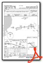
Standard Terminal Arrival (STAR) Charts


Instrument Approach Procedure (IAP) Charts


Nearby Airports with Instrument Procedures
| ID | Name | Heading / Distance | ||
|---|---|---|---|---|
 |
06FA | William P Gwinn Airport | 303° | 6.8 |
|
KPBI | Palm Beach International Airport | 145° | 11.9 |
|
KLNA | Palm Beach County Park Airport | 153° | 16.8 |
|
KSUA | Witham Field Airport | 000° | 20.1 |
|
KPHK | Palm Beach County Glades Airport | 261° | 25.5 |
|
KBCT | Boca Raton Airport | 167° | 28.6 |
|
KPMP | Pompano Beach Airpark Airport | 170° | 36.3 |
|
KFXE | Fort Lauderdale Exec Airport | 175° | 38.9 |
|
KFPR | Treasure Coast International Airport | 348° | 39.8 |
|
KOBE | Okeechobee County Airport | 306° | 42.0 |
|
2IS | Airglades Airport | 261° | 45.0 |
|
KFLL | Fort Lauderdale/Hollywood International Airport | 175° | 46.5 |
Airport Images

By: ferraf


