Login
Register


OBE
Okeechobee County Airport
Official FAA Data Effective 2026-02-19 0901Z
Chart Supplement

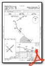
VFR Chart of KOBE
Sectional Charts at SkyVector.com
IFR Chart of KOBE
Enroute Charts at SkyVector.com
Location Information for KOBE
Coordinates: N27°15.99' / W80°51.02'Located 03 miles NW of Okeechobee, Florida on 864 acres of land. View all Airports in Florida.
Surveyed Elevation is 33 feet MSL.
Operations Data
|
|
Airport Communications
| AWOS-3: | 118.675 Tel. 863-467-1148 |
|---|---|
| CTAF: | 123.000 |
| UNICOM: | 123.000 |
| AWOS-3 at SEF (28.5 NW): | 119.475 863-655-6424 |
| ASOS at FPR (28.8 NE): | 772-489-4281 |
| ATIS at FPR (29.0 NE): | 134.825 |
- APCH/DEP SVC PRVDD BY MIAMI ARTCC ON FREQS 132.25/370.9 (VERO BEACH RCAG).
Nearby Navigation Aids
|
| ||||||||||||||||||||||||||||||||||||||||||||||||||||||


Runway 05/23
| Dimensions: | 5000 x 100 feet / 1524 x 30 meters | |
|---|---|---|
| Surface: | Asphalt in Excellent Condition | |
| Edge Lighting: | Medium Intensity | |
| Runway 05 | Runway 23 | |
| Coordinates: | N27°15.73' / W80°51.32' | N27°16.31' / W80°50.67' |
| Elevation: | 32.9 | 32.8 |
| Traffic Pattern: | Left | Left |
| Runway Heading: | 45° True | 225° True |
| Markings: | Non-Precision Instrument in good condition. | Non-Precision Instrument in good condition. |
| Glide Slope Indicator | P4L (3.00° Glide Path Angle) | P4L (3.00° Glide Path Angle) |
| REIL: | Yes | Yes |
| Obstacles: | 43 ft Trees 1920 ft from runway, 300 ft left of center | 43 ft Trees 1430 ft from runway, 195 ft left of center |
Runway 14/32
| Dimensions: | 4001 x 75 feet / 1220 x 23 meters | |
|---|---|---|
| Surface: | Asphalt in Fair Condition | |
| Runway 14 | Runway 32 | |
| Coordinates: | N27°16.20' / W80°51.32' | N27°15.73' / W80°50.80' |
| Elevation: | 33.0 | 32.3 |
| Traffic Pattern: | Left | Left |
| Runway Heading: | 135° True | 315° True |
| Markings: | Non-Precision Instrument in fair condition. | Non-Precision Instrument in fair condition. |
| Glide Slope Indicator | P4L (3.00° Glide Path Angle) | P4L (3.00° Glide Path Angle) |
| Obstacles: | 34 ft Trees 1060 ft from runway, 175 ft left of center CTLG OBSTN EXCEEDS A 45 DEG SLP. |
5 ft Fence 200 ft from runway, 215 ft left of center 5 FT FENCE 200FT FM RWY END 215 FT L. |
Services Available
| Fuel: | 100LL (blue), Jet-A, Jet A+ |
|---|---|
| Transient Storage: | Tiedowns |
| Airframe Repair: | MINOR |
| Engine Repair: | MINOR |
| Bottled Oxygen: | NONE |
| Bulk Oxygen: | NONE |
| Other Services: | PILOT INSTRUCTION |
Ownership Information
| Ownership: | Publicly owned | |
|---|---|---|
| Owner: | OKEECHOBEE COUNTY | CONTACT PERSON: DEBORAH MANZO 863-763-6441 |
| 2800 NW 20TH TRL | ||
| OKEECHOBEE, FL 34972 | ||
| 863-763-6441 | ||
| Manager: | CHRISTOPHER GEORGES | |
| 2800 NW 20TH TRL | ||
| OKEECHOBEE, FL 34972 | ||
| 863-467-5505 | EMERGENCY CELL PHONE 863-634-1474 | |
Other Remarks
- FBO PHONE IS 863-467-5505.
- NON-POWERED FLT WI TFC PAT NA.
- TKOF & LNDG ON GRASS AT OWN RISK.
- FOR CD CTC MIAMI ARTCC AT 305-716-1731.
- APRON PCR VALUE: 203/F/A/X/T
- TWY A PCR VALUE: 378/F/A/X/T
- AFT HRS CALL 863-657-8761
- CALM WIND RWY.
- ACTVT REIL RWY 05 & 23; MIRL RWY 05/23, - CTAF
Weather Minimums

Instrument Approach Procedure (IAP) Charts


Nearby Airports with Instrument Procedures
| ID | Name | Heading / Distance | ||
|---|---|---|---|---|
 |
KSEF | Sebring Regional Airport | 293° | 28.6 |
|
KFPR | Treasure Coast International Airport | 061° | 29.0 |
|
KPHK | Palm Beach County Glades Airport | 163° | 30.0 |
|
KVRB | Vero Beach Regional Airport | 044° | 32.8 |
|
2IS | Airglades Airport | 198° | 33.6 |
|
KSUA | Witham Field Airport | 098° | 34.0 |
|
06FA | William P Gwinn Airport | 127° | 35.2 |
|
X26 | Sebastian Municipal Airport | 029° | 37.8 |
|
KAVO | Avon Park Exec Airport | 298° | 41.1 |
|
F45 | North Palm Beach County General Aviation Airport | 126° | 42.0 |
|
X14 | La Belle Municipal Airport | 224° | 44.2 |
|
X59 | Valkaria Airport | 020° | 44.4 |
Airport Images
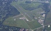
By: chabrier
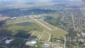
By: skyhawkfl


