Login
Register


2Y4
Rockwell City Municipal Airport
Official FAA Data Effective 2025-11-27 0901Z
Chart Supplement

VFR Chart of 2Y4
Sectional Charts at SkyVector.com
IFR Chart of 2Y4
Enroute Charts at SkyVector.com
Location Information for 2Y4
Coordinates: N42°23.27' / W94°37.13'Located 01 miles SE of Rockwell City, Iowa on 32 acres of land. View all Airports in Iowa.
Surveyed Elevation is 1215 feet MSL.
Operations Data
|
|
Airport Communications
| CTAF: | 122.800 |
|---|---|
| UNICOM: | 122.800 |
| AWOS-3PT at FOD (21.3 NE): | 118.775 515-955-5490 |
| AWOS-3 at CIN (21.9 S): | 118.025 712-792-2306 |
| AWOS-3 at SLB (30.3 NW): | 118.525 712-732-2301 |
Nearby Navigation Aids
|
| ||||||||||||||||||||||||||||||||||||||||||||||||||||||


Runway 12/30
| Dimensions: | 3503 x 60 feet / 1068 x 18 meters | |
|---|---|---|
| Surface: | Concrete in Fair Condition | |
| Weight Limits: | 6 /R/D/W/U | |
| Edge Lighting: | Medium Intensity | |
| Runway 12 | Runway 30 | |
| Coordinates: | N42°23.41' / W94°37.47' | N42°23.12' / W94°36.80' |
| Elevation: | 1215.9 | 1214.9 |
| Traffic Pattern: | Left | Left |
| Runway Heading: | 120° True | 300° True |
| Displaced Threshold: | 1205 Feet | |
| Declared Distances: | TORA:3500 TODA:3500 ASDA:3500 LDA:2300 | TORA:3500 TODA:3500 ASDA:3500 LDA:3500 |
| Markings: | Basic in fair condition. | Basic in fair condition. |
| Obstacles: | 16 ft Pole 372 ft from runway, 82 ft right of center APCH RATIO 50:1 FM DSPLCD THR. |
66 ft Tree 633 ft from runway, 120 ft left of center |
Services Available
| Fuel: | 100LL (blue) |
|---|---|
| Transient Storage: | Tiedowns |
| Airframe Repair: | NONE |
| Engine Repair: | NONE |
| Bottled Oxygen: | NONE |
| Bulk Oxygen: | NONE |
Ownership Information
| Ownership: | Publicly owned | |
|---|---|---|
| Owner: | ROCKWELL CITY | |
| 335 MAIN | ||
| ROCKWELL CITY, IA 50579 | ||
| 712-297-7041 | ||
| Manager: | PHILIP HAMMEN | |
| 335 MAIN | ||
| ROCKWELL CITY, IA 50579 | ||
| 712-297-7041 | ||
Other Remarks
- RADIO CTLD ACFT INVOF ARPT.
- FOR CD CTC MINNEAPOLIS ARTCC AT 651-463-5588.
- 0LL FOR FUEL CALL POLICE AT (712) 297-7583.
- DUSK-DAWN. FOR MIRL RY 12/30 KEY 122.8 3 TIMES HIGH INTST ONLY.
Nearby Airports with Instrument Procedures
| ID | Name | Heading / Distance | ||
|---|---|---|---|---|
 |
KSKI | Sac City Municipal Airport | 268° | 16.0 |
|
KFOD | Fort Dodge Regional Airport | 062° | 21.3 |
|
KPOH | Pocahontas Municipal Airport | 356° | 21.3 |
|
KCIN | Arthur N Neu Airport | 200° | 21.8 |
|
KEFW | Jefferson Municipal Airport | 151° | 25.8 |
|
KSLB | Storm Lake Municipal Airport | 294° | 30.3 |
|
KEBS | Webster City Municipal Airport | 084° | 33.5 |
|
KEAG | Eagle Grove Municipal Airport | 057° | 36.7 |
|
KPRO | Perry Municipal Airport | 148° | 39.4 |
|
KBNW | Boone Municipal Airport | 120° | 39.9 |
|
KDNS | Denison Municipal Airport | 234° | 41.6 |
|
KGCT | Guthrie County Regional Airport | 168° | 42.8 |
Airport Images
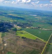
By: Bandco


