Login
Register
32PA
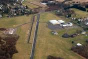
Perkiomen Valley Airport
Official FAA Data Effective 2024-05-16 0901Z
VFR Chart of 32PA
Sectional Charts at SkyVector.com
IFR Chart of 32PA
Enroute Charts at SkyVector.com
Location Information for 32PA
Coordinates: N40°12.24' / W75°25.82'Located 02 miles NE of Collegeville, Pennsylvania on 60 acres of land. View all Airports in Pennsylvania.
Estimated Elevation is 277 feet MSL.
Operations Data
|
|
Airport Communications
| PHILADELPHIA APPROACH: | 126.85 263.125 |
|---|---|
| PHILADELPHIA DEPARTURE: | 126.85 263.125 |
| CLEARANCE DELIVERY: | 118.55 |
| CTAF: | 122.800 |
| UNICOM: | 122.800 |
| ASOS at PTW (6.2 W): | 119.425 610-495-0823 |
| AWOS-3 at LOM (8.6 SE): | 118.925 215-646-1068 |
| AWOS-3 at CKZ (12.6 NE): | 126.325 215-257-7291 |
- CLEARANCE DELIVERY PHILADELPHIA APCH TF 800-354-9884.
Nearby Navigation Aids
|
| ||||||||||||||||||||||||||||||||||||||||||||||||||||||||||||
Runway 09/27
| Dimensions: | 2880 x 40 feet / 878 x 12 meters | |
|---|---|---|
| Surface: | Asphalt in Poor Condition UNSEALED CRACKS AND JOINTS IN ASPH. | |
| Weight Limits: | S-12 | |
| Runway 09 | Runway 27 | |
| Coordinates: | N40°12.19' / W75°26.12' | N40°12.30' / W75°25.51' |
| Elevation: | 245.0 | 273.0 |
| Traffic Pattern: | Left | Left |
| Runway Heading: | 76° True | 256° True |
| Displaced Threshold: | 420 Feet DTHR LGTS 150 FT DOWN RWY FM THR MARKING. |
370 Feet DTHR MKD WITH 2 PARL WHITE LINES; LGTD WITH 4 RED & GREEN LGTS EACH SIDE OF RWY. |
| Markings: | Non-Standard in poor condition. | Non-Standard in poor condition. |
| Obstacles: | 45 ft Trees 203 ft from runway APCH RATIO 13:1 TO DTHR. 20 FT ROAD AT THR 37 FT LEFT TO 250 FT RIGHT. MULT TREES 50 FT IN OFZ. |
58 ft Trees 806 ft from runway, 42 ft left of center APCH RATIO 20:1 TO DTHR. 7 FT RD AT THR 135 FT RIGHT TO 192 FT LEFT. 48 FT TREES 99 FT FM RWY END. |
Services Available
| Fuel: | NONE |
|---|---|
| Transient Storage: | Tiedowns |
| Airframe Repair: | NOT AVAILABLE |
| Engine Repair: | NOT AVAILABLE |
| Bottled Oxygen: | NONE |
| Bulk Oxygen: | NONE |
| Other Services: | PARACHUTE JUMP ACTIVITY |
Ownership Information
| Ownership: | Privately Owned | |
|---|---|---|
| Owner: | PV53, LLC | |
| 2620 EGYPT ROAD | ||
| EAGLEVILLE, PA 19403 | ||
| 610-999-3560 | ||
| Manager: | DAVID RITTENHOUSE | |
| 767 COLLEGEVILLE RD | ||
| COLLEGEVILLE, PA 19426 | ||
| (610) 999-3560 | ||
Operational Statistics
| Single Engine Aircraft Based on Field: | 3 | Statistics collected for 12 month period ending 2018-09-20 | |
|---|---|---|---|
| Multi-Engine Aircraft Based on Field: | none | Annual Commercial Operations: | none |
| Jet Aircraft Based on Field: | none | Annual Commuter Operations: | none |
| Helicopters Based on Field: | none | Annual Air Taxi Operations: | none |
| Military Aircraft Based on Field: | none | Annual Military Operations: | 10 |
| Gliders Based on Field: | none | Annual GA Local Operations: | 150 |
| Ultralights Based on Field: | none | Annual GA Itinerant Operations: | 100 |
Other Remarks
- THIS AIRPORT HAS BEEN SURVEYED BY THE NATIONAL GEODETIC SURVEY.
- FOR CD CTC PHILADELPHIA APCH AT 800-354-9884.
- ARPT CLSD FOR PUB USE.
- DEER, FOX, GEESE ON AND INVOF RWY.
- MARKINGS, ARROWS SML AND MISALIGNED, DBL THR BAR AND SML NRS, FADED.
- MARKINGS, ARROWS SML AND MISALIGNED, DBL THR BAR AND SML NRS, FADED.
Nearby Airports with Instrument Procedures
| ID | Name | Heading / Distance | ||
|---|---|---|---|---|
 |
KPTW | Heritage Field Airport | 290° | 6.2 |
 |
KLOM | Wings Field Airport | 117° | 8.6 |
 |
N47 | Pottstown Municipal Airport | 287° | 11.6 |
 |
KCKZ | Pennridge Airport | 029° | 12.8 |
 |
KUKT | Quakertown Airport | 009° | 14.0 |
 |
KOQN | Brandywine Regional Airport | 208° | 14.6 |
 |
KDYL | Doylestown Airport | 061° | 16.1 |
 |
KPNE | Northeast Philadelphia Airport | 110° | 20.7 |
 |
KPHL | Philadelphia International Airport | 156° | 21.7 |
 |
KXLL | Allentown Queen City Municipal Airport | 353° | 22.1 |
 |
KMQS | Chester County G O Carlson Airport | 236° | 24.2 |
 |
KRDG | Reading Regional/Carl A Spaatz Field Airport | 293° | 26.7 |


