Login
Register


CKZ
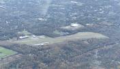
Pennridge Airport
Official FAA Data Effective 2026-01-22 0901Z
Chart Supplement

VFR Chart of KCKZ
Sectional Charts at SkyVector.com
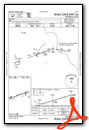
IFR Chart of KCKZ
Enroute Charts at SkyVector.com
Location Information for KCKZ
Coordinates: N40°23.35' / W75°17.43'Located 01 miles N of Perkasie, Pennsylvania on 270 acres of land. View all Airports in Pennsylvania.
Surveyed Elevation is 567 feet MSL.
TPA FOR LIGHT ACFT 800 FT AGL; TPA FOR TURBO PROP & JETS 1200 FT AGL.
Operations Data
|
|
Airport Communications
| AWOS-3: | 126.325 Tel. 215-257-7291 |
|---|---|
| PHILADELPHIA APPROACH: | 123.8 291.7 |
| PHILADELPHIA DEPARTURE: | 123.8 291.7 |
| CLEARANCE DELIVERY: | 118.55 |
| UNICOM: | 123.000 |
| CTAF: | 123.000 |
| AWOS-3 at UKT (5.0 NW): | 119.475 215-538-7610 |
| ASOS at DYL (8.4 SE): | 118.875 215-345-0392 |
| AWOS-3 at XLL (14.2 NW): | 127.875 610-231-3111 |
- CLEARANCE DELIVERY PHILADELPHIA APCH TF 800-354-9884.
Nearby Navigation Aids
|
| ||||||||||||||||||||||||||||||||||||||||||||||||||||||||||||


Runway 08/26
CLSD TO TOUCH & GO LDGS. | ||
| Dimensions: | 4211 x 100 feet / 1284 x 30 meters | |
|---|---|---|
| Surface: | Asphalt / Porous Friction Course in Good Condition | |
| Weight Limits: | D-26 | |
| Edge Lighting: | Medium Intensity | |
| Runway 08 | Runway 26 | |
| Coordinates: | N40°23.23' / W75°17.85' | N40°23.47' / W75°17.00' |
| Elevation: | 519.8 | 567.6 |
| Traffic Pattern: | Left | Left |
| Runway Heading: | 70° True | 250° True |
| Displaced Threshold: | 266 Feet | 351 Feet |
| Markings: | Non-Precision Instrument in good condition. | Non-Precision Instrument in good condition. |
| Glide Slope Indicator | P2L (3.78° Glide Path Angle) | P2L (4.00° Glide Path Angle) |
| Obstacles: | 23 ft Trees 247 ft from runway, 48 ft right of center APCH RATIO 13:1 TO DTHR. |
55 ft Trees 490 ft from runway, 289 ft right of center APCH RATIO 13:1 TO DTHR. 10 FT BLAST FENCE AT RWY END. 55 FT TREES, 490FT FM RWY END, 289 FT RIGHT. |
Services Available
| Fuel: | 100LL (blue), Jet-A |
|---|---|
| Transient Storage: | Hangars,Tiedowns |
| Airframe Repair: | MAJOR |
| Engine Repair: | MAJOR |
| Bottled Oxygen: | NONE |
| Bulk Oxygen: | NONE |
| Other Services: | PARACHUTE JUMP ACTIVITY SKYDIVING INSTRUCTION. |
Ownership Information
| Ownership: | Privately Owned | |
|---|---|---|
| Owner: | PENNRIDGE DEVELOPMENT LLC | |
| 1100 RIDGE RD | ||
| PERKASIE, PA 18944 | ||
| 215-257-0166 | ||
| Manager: | JEAN CURRY | |
| 1100 N RIDGE RD | ||
| PERKASIE, PA 18944 | ||
| 267-718-4254 | ||
Other Remarks
- OCCASIONAL DEER AND WILD TURKEYS INVOF RWY.
- SKYDIVING ACT DLY DAWN TO DUSK.
- FOR CD CTC PHILADELPHIA APCH AT 800-354-9884.
- FOR SVC AFT HRS CALL AMGR.
- RWY DOES NOT HAVE AIMING POINT.
- ACTVT PAPI RWY 08 & 26; MIRL 08/26 - CTAF.
- TPA FOR LIGHT ACFT 800 FT AGL; TPA FOR TURBO PROP & JETS 1200 FT AGL.
Weather Minimums
Instrument Approach Procedure (IAP) Charts

Nearby Airports with Instrument Procedures
| ID | Name | Heading / Distance | ||
|---|---|---|---|---|
 |
KUKT | Quakertown Airport | 303° | 5.0 |
|
KDYL | Doylestown Airport | 113° | 8.4 |
|
KXLL | Allentown Queen City Municipal Airport | 320° | 14.1 |
|
KPTW | Heritage Field Airport | 233° | 15.2 |
|
KLOM | Wings Field Airport | 175° | 15.1 |
|
N85 | Alexandria Airport | 046° | 17.2 |
|
KABE | Lehigh Valley International Airport | 336° | 17.2 |
|
N40 | Sky Manor Airport | 053° | 17.8 |
|
N47 | Pottstown Municipal Airport | 246° | 19.1 |
|
N43 | Braden Airpark Airport | 005° | 21.3 |
|
KPNE | Northeast Philadelphia Airport | 144° | 22.5 |
|
KTTN | Trenton Mercer Airport | 106° | 22.9 |
")


Comments
Vector Landing Fees
Expect a landing fee snail mailed several weeks later, even if you purchased $200 of gas.
Sylvan Martin
Pages