Login
Register


PNE
Northeast Philadelphia Airport
Official FAA Data Effective 2026-01-22 0901Z
From the Flight Deck
Chart Supplement

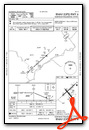
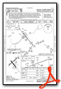
KPNE Airport Diagram

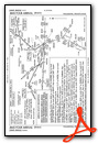
VFR Chart of KPNE
Sectional Charts at SkyVector.com
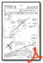
IFR Chart of KPNE
Enroute Charts at SkyVector.com
Location Information for KPNE
Coordinates: N40°4.92' / W75°0.63'Located 10 miles NE of Philadelphia, Pennsylvania on 1150 acres of land. View all Airports in Pennsylvania.
Surveyed Elevation is 119 feet MSL.
Operations Data
|
|
Airport Communications
| ATIS: | 121.15 |
|---|---|
| ASOS: | Tel. 215-897-9068 |
| NORTHEAST PHILADELPHIA TOWER: | 126.9 278.8 |
| NORTHEAST PHILADELPHIA GROUND: | 121.7 |
| PHILADELPHIA APPROACH: | 123.8 291.7 |
| PHILADELPHIA DEPARTURE: | 123.8 291.7 |
| CLEARANCE DELIVERY: | 127.25 |
| CTAF: | 126.900 |
| UNICOM: | 122.950 |
| ASOS at VAY (11.3 SE): | 119.325 609-267-1176 |
| AWOS-3 at LOM (12.2 W): | 118.925 215-646-1068 |
| ASOS at TTN (14.7 NE): | 126.775 609-538-8690 |
- CLEARANCE DELIVERY PHILADELPHIA APCH TF 800-354-9884.
- EMERG FREQ 121.5 NOT AVAILABLE AT TOWER.
Nearby Navigation Aids
|
| ||||||||||||||||||||||||||||||||||||||||||||||||||||||||||||


Runway 06/24
| Dimensions: | 7000 x 100 feet / 2134 x 30 meters | |
|---|---|---|
| Surface: | Asphalt / Grooved in Good Condition | |
| Weight Limits: | 80 /F/A/X/T, S-120, D-250, ST-550 | |
| Edge Lighting: | High Intensity | |
| Runway 06 | Runway 24 | |
| Coordinates: | N40°4.65' / W75°1.22' | N40°5.42' / W75°0.09' |
| Elevation: | 116.7 | 113.7 |
| Traffic Pattern: | Left | Left |
| Runway Heading: | 48° True | 228° True |
| Displaced Threshold: | 498 Feet | |
| Declared Distances: | TORA:7000 TODA:7000 ASDA:7000 LDA:6502 | TORA:6826 TODA:7000 ASDA:6102 LDA:6102 |
| Markings: | Precision Instrument in good condition. | Precision Instrument in good condition. |
| Glide Slope Indicator | P4L (3.00° Glide Path Angle) | P4R (3.00° Glide Path Angle) |
| Approach Lights: | MALSR 1,400 Foot Medium-intensity Approach Lighting System with runway alignment indicator lights. | |
| REIL: | Yes | |
| Obstacles: | 59 ft Trees 1524 ft from runway, 372 ft left of center | 68 ft Trees 2273 ft from runway, 769 ft right of center |
Runway 15/33
| Dimensions: | 4999 x 150 feet / 1524 x 46 meters | |
|---|---|---|
| Surface: | Asphalt / Grooved in Good Condition | |
| Weight Limits: | S-40, D-55 | |
| Edge Lighting: | Medium Intensity | |
| Runway 15 | Runway 33 | |
| Coordinates: | N40°5.07' / W75°0.95' | N40°4.43' / W75°0.27' |
| Elevation: | 119.8 | 107.9 |
| Traffic Pattern: | Left | Left |
| Runway Heading: | 141° True | 321° True |
| Markings: | Non-Precision Instrument in good condition. | Non-Precision Instrument in good condition. |
| Glide Slope Indicator | P4L (3.00° Glide Path Angle) | P4L (3.00° Glide Path Angle) |
| REIL: | Yes | Yes |
| Obstacles: | 41 ft Tree 1023 ft from runway, 4 ft left of center | 44 ft Tree 1472 ft from runway, 296 ft right of center |
Services Available
| Fuel: | 100LL (blue), Jet-A |
|---|---|
| Transient Storage: | Hangars,Tiedowns |
| Airframe Repair: | MAJOR |
| Engine Repair: | MAJOR |
| Bottled Oxygen: | HIGH/LOW |
| Bulk Oxygen: | HIGH |
| Other Services: | AIR FREIGHT SERVICES,AIR AMBULANCE SERVICES,AVIONICS,CARGO HANDLING SERVICES,CHARTER SERVICE,PILOT INSTRUCTION,AIRCRAFT RENTAL,AIRCRAFT SALES,ANNUAL SURVEYING |
Ownership Information
| Ownership: | Publicly owned | |
|---|---|---|
| Owner: | CITY OF PHILADELPHIA | |
| PHILADELPHIA INT ARPT | ||
| PHILADELPHIA, PA 19153 | ||
| 215-937-6800 | ||
| Manager: | JOHN BREWER | |
| 9800 ASHTON ROAD | ||
| PHILADELPHIA, PA 19114 | ||
| 215-937-7968 | ||
Other Remarks
- TURBOJET ACFT ARE CONFINED TO FULL LENGTH RWY 6/24 UNLESS STRONG WINDS DICTATE OTHERWISE.
- BE ALERT: 3 LARGE BRIGHTLY LIT JUMBOTRON SIGNS APRX 3 MILES NE OF AER 24. THESE SIGNS MAY CAUSE VISUAL ILLUSIONS DURING AN APCH OR MISSED APCH. PILOTS BE AT ADVISED.
- FOR CD WHEN ATCT IS CLSD CTC PHL APCH AT (800) 354-9884.
- TWY L3 SAFETY AREA NON STD.
- TWY J1 NON MOVEMENT AREA.
- COMPASS ROSE NOT FOR PUB USE.
- TWY J BTN TWY G AND HEL APN IS NON MOV AREA.
- LMT TGL OPNS TO 0900-2200 MON-SAT AND 1200-2200 SUN; 5 PER FLT FOR NOISE ABATEMENT.
- RWY 15 IS NOISE SENSITIVE. RWY 15 ARRIVALS ARE REQUESTED TO FLY AT OR ABOVE GLIDE PATH.
- ARPT CLSD TO PART 121 AIR CARRIER AND PART 135 SCHEDULED SVC.
- DEER & BIRDS ON & INVOF ARPT.
- TPA ACFT LESS THAN 12500 LBS 1120 MSL; ACFT 12500 LBS OR MORE & ALL TURBOJET & TURBINE PWRD ACFT 1620 MSL; ROTARY WING ACFT 920 MSL.
- BE ALERT FOR ARPT VEHICLES WHEN TWR CLSD.
- WHEN ATCT CLSD HIRL RWY 06/24 PRESET MED INTST, TO INCRS INTST AND ACTVT MALSR RWY 24 - CTAF
Weather Minimums

Standard Terminal Arrival (STAR) Charts


Instrument Approach Procedure (IAP) Charts


Nearby Airports with Instrument Procedures
| ID | Name | Heading / Distance | ||
|---|---|---|---|---|
 |
KVAY | South Jersey Regional Airport | 137° | 11.3 |
|
KLOM | Wings Field Airport | 285° | 12.2 |
|
N14 | Flying W Airport | 133° | 12.9 |
|
KTTN | Trenton Mercer Airport | 037° | 14.8 |
|
KDYL | Doylestown Airport | 341° | 15.9 |
|
KPHL | Philadelphia International Airport | 220° | 16.5 |
|
19N | Pine Valley Airport | 170° | 18.4 |
|
KWRI | Mc Guire Field (Joint Base Mc Guire Dix Lakehurst) Airport | 101° | 19.7 |
|
N87 | Trenton-Robbinsville Airport | 067° | 20.4 |
|
KCKZ | Pennridge Airport | 325° | 22.5 |
|
17N | Cross Keys Airport | 182° | 22.6 |
|
39N | Princeton Airport | 040° | 25.0 |
Airport Images
Do you have a recent image of this airport? Upload it here!


