Login
Register
3GM
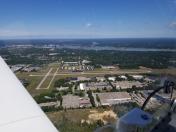
Grand Haven Memorial Airpark Airport
Official FAA Data Effective 2025-11-27 0901Z
VFR Chart of 3GM
Sectional Charts at SkyVector.com
IFR Chart of 3GM
Enroute Charts at SkyVector.com
Location Information for 3GM
Coordinates: N43°2.04' / W86°11.89'Located 02 miles SE of Grand Haven, Michigan on 155 acres of land. View all Airports in Michigan.
Surveyed Elevation is 603 feet MSL.
Operations Data
|
|
Airport Communications
| GREAT LAKES APPROACH: | 133.825 290.35 |
|---|---|
| GREAT LAKES DEPARTURE: | 133.825 290.35 |
| CTAF: | 122.700 |
| UNICOM: | 122.700 |
| ATIS at MKG (8.2 N): | 124.3 |
| ASOS at MKG (8.4 N): | 231-798-1317 |
| ASOS at BIV (17.9 S): | 119.025 616-394-0190 |
- APCH/DEP SVC PRVDD BY CHICAGO ARTCC ON FREQS 128.5/273.525 (PULLMAN RCAG) WHEN GREAT LAKES APCH CTL CLSD.
Nearby Navigation Aids
|
| ||||||||||||||||||||||||||||||||||||||||||||||||||||||||||||
Runway 09/27
| Dimensions: | 3752 x 75 feet / 1144 x 23 meters | |
|---|---|---|
| Surface: | Asphalt in Excellent Condition | |
| Weight Limits: | S-8 | |
| Edge Lighting: | Medium Intensity | |
| Runway 09 | Runway 27 | |
| Coordinates: | N43°2.05' / W86°12.20' | N43°2.05' / W86°11.36' |
| Elevation: | 602.3 | 591.5 |
| Traffic Pattern: | Left | Left |
| Runway Heading: | 90° True | 270° True |
| Markings: | Non-Precision Instrument in good condition. | Non-Precision Instrument in good condition. |
| Glide Slope Indicator | P2L (3.00° Glide Path Angle) | P2L (4.00° Glide Path Angle) |
| REIL: | Yes | Yes |
| Obstacles: | 45 ft Trees 941 ft from runway, 300 ft right of center | 45 ft Tree 675 ft from runway, 321 ft left of center |
Runway 18/36
| Dimensions: | 2058 x 60 feet / 627 x 18 meters | |
|---|---|---|
| Surface: | Asphalt in Fair Condition | |
| Weight Limits: | S-8 | |
| Edge Lighting: | Medium Intensity | |
| Runway 18 | Runway 36 | |
| Coordinates: | N43°2.20' / W86°12.09' | N43°1.86' / W86°12.09' |
| Elevation: | 603.8 | 598.4 |
| Traffic Pattern: | Left | Left |
| Runway Heading: | 180° True | 0 |
| Markings: | Basic in fair condition. | Basic in fair condition. |
| Obstacles: | 15 ft Road 330 ft from runway, 138 ft right of center | 11 ft Road 285 ft from runway, 134 ft right of center |
Services Available
| Fuel: | 100LL (blue), Jet-A |
|---|---|
| Transient Storage: | Hangars,Tiedowns |
| Airframe Repair: | MAJOR |
| Engine Repair: | MAJOR |
| Bottled Oxygen: | NOT AVAILABLE |
| Bulk Oxygen: | NOT AVAILABLE |
| Other Services: | PARACHUTE JUMP ACTIVITY |
Ownership Information
| Ownership: | Publicly owned | |
|---|---|---|
| Owner: | CITY OF GRAND HAVEN | |
| 519 WASHINGTON AVE | ||
| GRAND HAVEN, MI 49417-1454 | ||
| 616-842-3210 | ||
| Manager: | EARLE BARES | |
| 16446 COMSTOCK ST | ||
| GRAND HAVEN, MI 49417-9423 | ||
| 616-842-4430 | CELL 616-847-0638. | |
Other Remarks
- UAS OPS WEST OF RWY 18 & NORTH OF RWY 09.
- DEER & LRG BIRDS ON & INVOF ARPT.
- PAJA SFC-14000 FT DLY SR-SS APR-OCT.
- FOR CD CTC GREAT LAKES APCH AT 269-459-3344, WHEN APCH CLSD CTC CHICAGO ARTCC AT 630-906-8921.
- LRG VEHICLE TFC ON ROADS IN RWY 18 & 36 APCH AREAS.
- ACTVT REIL RWY 09 & 27; PAPI RWY 09 & 27; MIRL RWY 09/27 & 18/36 - CTAF.
Weather Minimums
Instrument Approach Procedure (IAP) Charts
Nearby Airports with Instrument Procedures
| ID | Name | Heading / Distance | ||
|---|---|---|---|---|
 |
KMKG | Muskegon County Airport | 348° | 8.2 |
 |
Z98 | Ottawa Exec Airport | 137° | 17.6 |
 |
KBIV | West Michigan Regional Airport | 167° | 17.9 |
 |
8D4 | Paul C Miller/Sparta Airport | 076° | 23.5 |
 |
KFFX | Fremont Municipal Airport | 020° | 25.9 |
 |
KGRR | Gerald R Ford International Airport | 106° | 31.1 |
 |
35D | Padgham Field Airport | 151° | 34.4 |
 |
C04 | Oceana County Airport | 351° | 36.9 |
 |
KLWA | South Haven Area Regional Airport | 183° | 41.0 |
 |
6D6 | Greenville Municipal Airport | 080° | 42.0 |
 |
9D9 | Hastings Airport | 120° | 43.7 |
 |
13C | Lakeview/Griffith Field Airport | 058° | 48.0 |


