Login
Register
3VA3
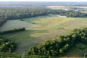
Flying Circus Aerodrome Airport
Official FAA Data Effective 2024-10-31 0901Z
VFR Chart of 3VA3
Sectional Charts at SkyVector.com
IFR Chart of 3VA3
Enroute Charts at SkyVector.com
Location Information for 3VA3
Coordinates: N38°33.02' / W77°42.95'Located 10 miles SE of Warrenton, Virginia. View all Airports in Virginia.
Estimated Elevation is 315 feet MSL.
Operations Data
|
|
Airport Communications
| AWOS-3 at HWY (2.2 N): | 120.350 540-788-4078 |
|---|---|
| AWOS-3 at CJR (6.8 W): | 119.325 540-727-0523 |
| ATIS at HEF (13.9 NE): | 125.175 |
Nearby Navigation Aids
|
| ||||||||||||||||||||||||||||||||||||||||||||||||||||||||||||
Runway 16/34
| Dimensions: | 2500 x 150 feet / 762 x 46 meters | |
|---|---|---|
| Surface: | Turf | |
| Runway 16 | Runway 34 | |
| Traffic Pattern: | Right | Left |
Runway 02/20
| Dimensions: | 2000 x 150 feet / 610 x 46 meters | |
|---|---|---|
| Surface: | Turf | |
| Runway 02 | Runway 20 | |
| Traffic Pattern: | Left | Right |
Services Available
| Fuel: | NONE |
|---|---|
| Transient Storage: | NONE |
| Airframe Repair: | NONE |
| Engine Repair: | NONE |
| Bottled Oxygen: | NOT AVAILABLE |
| Bulk Oxygen: | NOT AVAILABLE |
Ownership Information
| Ownership: | Privately Owned | |
|---|---|---|
| Owner: | FLYING CIRCUS AIRSHOWS INC | |
| P.O. BOX 99 | ||
| BEALTON, VA 22712 | ||
| 703-439-8661 | ||
| Manager: | JUSTIN B. CURRIER | |
| 17375 CROOKES FARM RD | ||
| RIXEYVILLE, VA 22737 | ||
| 540-212-3900 | ||
Other Remarks
- THIS FIELD FOR FLYING CIRCUS AERO INC; PRIVATE-AIRSHOW.
- UNMRKD/UNLGTD TREES & PLINES.
- FOR CD CTC POTOMAC APCH AT 866-709-4993.
Nearby Airports with Instrument Procedures
| ID | Name | Heading / Distance | ||
|---|---|---|---|---|
 |
KHWY | Warrenton/Fauquier Airport | 006° | 2.2 |
 |
KCJR | Culpeper Regional Airport | 257° | 6.9 |
 |
KHEF | Manassas Regional/Harry P Davis Field Airport | 042° | 13.9 |
 |
KRMN | Stafford Regional Airport | 126° | 15.2 |
 |
KNYG | Quantico Mcaf (Turner Field) Airport | 098° | 19.5 |
 |
KEZF | Shannon Airport | 143° | 21.1 |
 |
KOMH | Orange County Airport | 220° | 23.9 |
 |
KIAD | Washington Dulles International Airport | 026° | 26.7 |
 |
KDAA | Davison AAF Airport | 068° | 27.0 |
 |
2W5 | Maryland Airport | 084° | 30.4 |
 |
KGVE | Gordonsville Municipal Airport | 222° | 31.8 |
 |
KJYO | Leesburg Exec Airport | 013° | 32.5 |


