Login
Register


CJR
Culpeper Regional Airport
Official FAA Data Effective 2026-02-19 0901Z
Chart Supplement

VFR Chart of KCJR
Sectional Charts at SkyVector.com
IFR Chart of KCJR
Enroute Charts at SkyVector.com
Location Information for KCJR
Coordinates: N38°31.53' / W77°51.58'Located 07 miles NE of Culpeper, Virginia on 301 acres of land. View all Airports in Virginia.
Surveyed Elevation is 315 feet MSL.
Operations Data
|
|
Airport Communications
| AWOS-3: | 119.325 Tel. 540-727-0523 |
|---|---|
| POTOMAC APPROACH: | 128.525 306.925 |
| POTOMAC DEPARTURE: | 128.525 306.925 |
| CLEARANCE DELIVERY: | 121.6 |
| TIKEE STAR: | 120.45 306.925 |
| HYPER STAR: | 133.0 288.35 |
| CTAF: | 123.075 |
| TRSTN STAR: | 126.75 307.2 |
| UNICOM: | 123.075 |
| AWOS-3 at HWY (7.7 NE): | 120.350 540-788-4078 |
| AWOS-3 at OMH (18.8 SW): | 118.075 540-672-0505 |
| ATIS at HEF (20.0 NE): | 125.175 |
Nearby Navigation Aids
|
| ||||||||||||||||||||||||||||||||||||||||||||||||||||||||||||


Runway 04/22
| Dimensions: | 5000 x 100 feet / 1524 x 30 meters | |
|---|---|---|
| Surface: | Asphalt / Grooved in Good Condition | |
| Weight Limits: | 28 /F/B/X/U, S-40 | |
| Edge Lighting: | Medium Intensity | |
| Runway 04 | Runway 22 | |
| Coordinates: | N38°31.17' / W77°51.83' | N38°31.89' / W77°51.33' |
| Elevation: | 315.3 | 314.5 |
| Traffic Pattern: | Left | Left |
| Runway Heading: | 28° True | 208° True |
| Markings: | Non-Precision Instrument in good condition. | Non-Precision Instrument in good condition. |
| Glide Slope Indicator | P4L (3.00° Glide Path Angle) | P4L (3.00° Glide Path Angle) |
| REIL: | Yes | Yes |
| Obstacles: | 33 ft Trees 915 ft from runway, 247 ft left of center | 70 ft Trees 1363 ft from runway, 348 ft left of center |
Services Available
| Fuel: | 100LL (blue), Jet A+ |
|---|---|
| Transient Storage: | Tiedowns |
| Airframe Repair: | MAJOR |
| Engine Repair: | MAJOR |
| Bottled Oxygen: | NONE |
| Bulk Oxygen: | NONE |
| Other Services: | AIR AMBULANCE SERVICES,PILOT INSTRUCTION,AIRCRAFT RENTAL |
Ownership Information
| Ownership: | Publicly owned | |
|---|---|---|
| Owner: | COUNTY OF CULPEPER | |
| 302 N MAIN ST | ||
| CULPEPER, VA 22701 | ||
| 540-727-3427 | ||
| Manager: | TANYA WOODWARD | |
| 12517 BEVERLY FORD ROAD | ||
| BRANDY STATION, VA 22714 | ||
| 540-825-8280 | ||
Other Remarks
- THIS AIRPORT HAS BEEN SURVEYED BY THE NATIONAL GEODETIC SURVEY.
- DEER ON AND INVOF ARPT.
- GCO AVBL ON FREQ 121.6 THRU POTOMAC APCH CD. IF UNA, FOR CD CTC POTOMAC APCH AT 866-709-4993.
- CALL OUT SVC AVBL; FEES APPLY.
- MED-FLIGHT: IREG DEP PAT.
- ACTVT REIL RWY 04 & 22; PAPI RWY 04 & 22; MIRL RWY 04/22; TWY LGTS - CTAF.
Weather Minimums

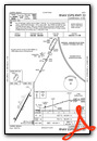
Standard Terminal Arrival (STAR) Charts
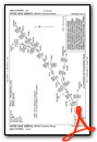


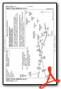
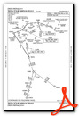
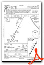
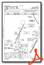
Instrument Approach Procedure (IAP) Charts


Nearby Airports with Instrument Procedures
| ID | Name | Heading / Distance | ||
|---|---|---|---|---|
 |
KHWY | Warrenton/Fauquier Airport | 062° | 7.9 |
|
KOMH | Orange County Airport | 207° | 18.8 |
|
KHEF | Manassas Regional/Harry P Davis Field Airport | 054° | 20.0 |
|
KRMN | Stafford Regional Airport | 111° | 20.4 |
|
KEZF | Shannon Airport | 128° | 24.8 |
|
KNYG | Quantico Mcaf (Turner Field) Airport | 092° | 26.2 |
|
KGVE | Gordonsville Municipal Airport | 213° | 26.4 |
|
KFRR | Front Royal-Warren County Airport | 321° | 29.9 |
|
KLUA | Luray Caverns Airport | 285° | 31.3 |
|
KLKU | Louisa County/Freeman Field Airport | 189° | 31.3 |
|
KIAD | Washington Dulles International Airport | 036° | 31.5 |
|
KDAA | Davison AAF Airport | 070° | 33.9 |
")
")


