Login
Register


42C
White Cloud Airport
Official FAA Data Effective 2026-01-22 0901Z
Chart Supplement

VFR Chart of 42C
Sectional Charts at SkyVector.com
IFR Chart of 42C
Enroute Charts at SkyVector.com
Location Information for 42C
Coordinates: N43°33.59' / W85°46.45'Located 01 miles N of White Cloud, Michigan on 110 acres of land. View all Airports in Michigan.
Estimated Elevation is 914 feet MSL.
Operations Data
|
|
Airport Communications
| UNICOM: | 122.800 |
|---|---|
| CTAF: | 122.800 |
| AWOS-3P at FFX (11.9 SW): | 118.775 231-928-0715 |
| AWOS-3P at RQB (15.3 NE): | 125.875 231-796-0884 |
| AWOS-AV at C04 (24.6 W): | 122.7 231-861-7415 |
Nearby Navigation Aids
|
| ||||||||||||||||||||||||||||||||||||||||||||||||||||||||||||


Runway 18/36
| Dimensions: | 2916 x 60 feet / 889 x 18 meters | |
|---|---|---|
| Surface: | Asphalt in Excellent Condition | |
| Edge Lighting: | Medium Intensity | |
| Runway 18 | Runway 36 | |
| Coordinates: | N43°33.83' / W85°46.50' | N43°33.35' / W85°46.40' |
| Elevation: | 911.0 | 910.0 |
| Traffic Pattern: | Left | Left |
| Runway Heading: | 172° True | 352° True |
| Displaced Threshold: | 500 Feet | |
| Markings: | Basic in good condition. | Basic in good condition. |
| Obstacles: | 26 ft Power Line 415 ft from runway, 147 ft right of center APCH RATIO 20:1 TO DTHR. |
|
Services Available
| Fuel: | 100LL (blue) |
|---|---|
| Transient Storage: | Tiedowns |
| Airframe Repair: | NOT AVAILABLE |
| Engine Repair: | NOT AVAILABLE |
| Bottled Oxygen: | NOT AVAILABLE |
| Bulk Oxygen: | NOT AVAILABLE |
Ownership Information
| Ownership: | Publicly owned | |
|---|---|---|
| Owner: | CITY OF WHITE CLOUD | |
| PO BOX 607 | ||
| WHITE CLOUD, MI 49349-0607 | ||
| 231-689-1194 | ||
| Manager: | JACOB ASKHER | |
| PO BOX 607 | ||
| WHITE CLOUD, MI 49349-0607 | ||
| 231-689-5891 | UNATNDD ARPT PHONE. | |
Other Remarks
- TO VERIFY SNOW REMOVAL CALL 231-689-1194.
- BIRDS ON & INVOF ARPT.
- UAS OPS WEST OF RWY 18/36.
- FOR CD CTC GREAT LAKES APCH AT 269-459-3344, WHEN APCH CLSD CTC CHICAGO ARTCC AT 630-906-8921.
- (CONTACT PHONE NR) CELL.
- 0LL FUEL AVBL H24 SELF SVC VIA CREDIT CARD.
- ACTVT MIRL RWY 18/36 - 4 CLICKS CTAF.
Nearby Airports with Instrument Procedures
| ID | Name | Heading / Distance | ||
|---|---|---|---|---|
 |
KFFX | Fremont Municipal Airport | 233° | 12.1 |
|
KRQB | Roben-Hood Airport | 050° | 15.3 |
|
7D3 | Baldwin Municipal Airport | 351° | 19.2 |
|
13C | Lakeview/Griffith Field Airport | 106° | 23.2 |
|
C04 | Oceana County Airport | 281° | 24.7 |
|
8D4 | Paul C Miller/Sparta Airport | 170° | 26.3 |
|
KMKG | Muskegon County Airport | 220° | 31.0 |
|
6D6 | Greenville Municipal Airport | 137° | 33.9 |
|
KLDM | Mason County Airport | 311° | 36.6 |
|
3GM | Grand Haven Memorial Airpark Airport | 210° | 36.6 |
|
KGRR | Gerald R Ford International Airport | 164° | 42.2 |
|
Z98 | Ottawa Exec Airport | 188° | 45.1 |
Airport Images
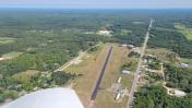
By: sunmanav8


