Login
Register


44N
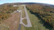
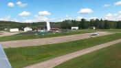
Sky Acres Airport
Official FAA Data Effective 2026-02-19 0901Z
Chart Supplement

VFR Chart of 44N
Sectional Charts at SkyVector.com
IFR Chart of 44N
Enroute Charts at SkyVector.com
Location Information for 44N
Coordinates: N41°42.45' / W73°44.28'Located 06 miles SW of Millbrook, New York on 205 acres of land. View all Airports in New York.
Surveyed Elevation is 697 feet MSL.
Operations Data
|
|
Airport Communications
| NEW YORK APPROACH: | 132.75 363.1 |
|---|---|
| NEW YORK DEPARTURE: | 132.75 363.1 |
| CTAF: | 122.800 |
| UNICOM: | 122.800 |
| ASOS at POU (8.1 SW): | 126.75 845-462-0648 |
| ATIS at POU (8.2 SW): | 126.75 |
| ATIS at SWF (20.5 SW): | 124.575 |
Nearby Navigation Aids
|
| ||||||||||||||||||||||||||||||||||||||||||||||||||||||||||||


Runway 17/35
| Dimensions: | 3828 x 60 feet / 1167 x 18 meters | |
|---|---|---|
| Surface: | Asphalt in Good Condition | |
| Weight Limits: | S-20 | |
| Edge Lighting: | Medium Intensity | |
| Runway 17 | Runway 35 | |
| Coordinates: | N41°42.73' / W73°44.47' | N41°42.17' / W73°44.09' |
| Elevation: | 646.1 | 697.0 |
| Traffic Pattern: | Left | Left |
| Runway Heading: | 153° True | 333° True |
| Markings: | Non-Precision Instrument in good condition. | Non-Precision Instrument in good condition. |
| Glide Slope Indicator | P2L (3.00° Glide Path Angle) PAPI RWY 35 UNUSBL 8 DEGS RIGHT OF CNTRLN. | |
| Obstacles: | 19 ft Trees 336 ft from runway, 256 ft right of center RWY 17 22 FT TREES 180 FT FM RWY END 159 FT LEFT. |
49 ft Trees 713 ft from runway, 88 ft right of center RWY 35 16 FT TREES 116 FT FM RWY END 125 FT RIGHT. |
Services Available
| Fuel: | 100LL (blue) |
|---|---|
| Transient Storage: | Tiedowns |
| Airframe Repair: | MAJOR |
| Engine Repair: | MAJOR |
| Bottled Oxygen: | NOT AVAILABLE |
| Bulk Oxygen: | NOT AVAILABLE |
Ownership Information
| Ownership: | Privately Owned | |
|---|---|---|
| Owner: | SKY ACRES ENTERPRISES INC | |
| 30 AIRWAY DRIVE | ||
| LAGRANGEVILLE, NY 12540 | ||
| 845-677-5010 | ||
| Manager: | STEVEN STYLES | |
| 30 AIRWAY DRIVE | ||
| LAGRANGEVILLE, NY 12540 | ||
| 845-677-5010 | ||
Other Remarks
- RY 17/35 SAFETY AREAS HAVE 30 FT DROPOFFS SLOPING 20 FT FM THLD AT BOTH ENDS.
- PARALLEL TWY NOT LGTD.
- FOR CD CTC NEW YORK APCH AT 516-683-2448
- COLD TEMPERATURE AIRPORT. ALTITUDE CORRECTION REQUIRED AT OR BELOW -22C.
- 0LL SELF-SVC FUEL AVBL 24/7.
- SS-SR ACTVT PAPI RWY 35; MIRL RWY 17/35 - CTAF.
Weather Minimums

Instrument Approach Procedure (IAP) Charts


Nearby Airports with Instrument Procedures
| ID | Name | Heading / Distance | ||
|---|---|---|---|---|
 |
KPOU | Hudson Valley Regional Airport | 233° | 8.2 |
|
20N | Kingston-Ulster Airport | 328° | 19.5 |
|
KSWF | New York Stewart International Airport | 233° | 20.5 |
|
KDXR | Danbury Municipal Airport | 150° | 23.2 |
|
KMGJ | Orange County Airport | 243° | 26.4 |
|
N89 | Joseph Y Resnick Airport | 272° | 28.7 |
|
KOXC | Waterbury-Oxford Airport | 116° | 30.4 |
|
KGBR | Great Barrington Airport | 027° | 32.3 |
|
N82 | Wurtsboro/Sullivan County Airport | 258° | 33.1 |
|
06N | Randall Airport | 240° | 33.8 |
|
1B1 | Columbia County Airport | 002° | 35.0 |
|
KHPN | Westchester County Airport | 177° | 38.4 |