Login
Register


POU
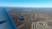
Hudson Valley Regional Airport
Official FAA Data Effective 2026-02-19 0901Z
Chart Supplement

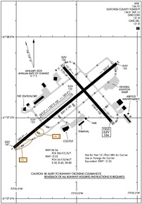
KPOU Airport Diagram
VFR Chart of KPOU
Sectional Charts at SkyVector.com
IFR Chart of KPOU
Enroute Charts at SkyVector.com
Location Information for KPOU
Coordinates: N41°37.60' / W73°53.05'Located 04 miles S of Poughkeepsie, New York on 640 acres of land. View all Airports in New York.
Surveyed Elevation is 163 feet MSL.
TPA SMALL ACFT 1034 FT, LARGE ACFT 1834 FT.
Operations Data
|
|
Airport Communications
| ATIS: | 126.75 |
|---|---|
| ASOS: | 126.75 Tel. 845-462-0648 |
| DUTCHESS COUNTY TOWER: | 124.0 269.15 |
| DUTCHESS COUNTY GROUND: | 121.8 |
| NEW YORK APPROACH: | 132.75 363.1 |
| NEW YORK DEPARTURE: | 132.75 363.1 |
| CLEARANCE DELIVERY: | 121.8 |
| TRESA STAR: | 132.75 363.1 |
| UNICOM: | 122.950 |
| CTAF: | 124.000 |
| ATIS at SWF (12.3 SW): | 124.575 |
| ASOS at MGJ (18.5 W): | 119.275 845-457-1486 |
| ASOS at DXR (23.6 SE): | 127.75 203-791-8227 |
Nearby Navigation Aids
|
| ||||||||||||||||||||||||||||||||||||||||||||||||||||||||||||


Runway 06/24
| Dimensions: | 5001 x 100 feet / 1524 x 30 meters | |
|---|---|---|
| Surface: | Asphalt / Grooved in Excellent Condition | |
| Edge Lighting: | High Intensity | |
| Runway 06 | Runway 24 | |
| Coordinates: | N41°37.32' / W73°53.52' | N41°37.84' / W73°52.67' |
| Elevation: | 146.6 | 154.8 |
| Traffic Pattern: | Left | Left |
| Runway Heading: | 51° True | 231° True |
| Displaced Threshold: | 115 Feet | |
| Declared Distances: | TORA:5001 TODA:5001 ASDA:5001 LDA:5001 | TORA:5001 TODA:5001 ASDA:5001 LDA:4886 |
| Markings: | Precision Instrument in good condition. | Non-Precision Instrument in good condition. |
| Glide Slope Indicator | P4L (3.00° Glide Path Angle) | P4L (3.42° Glide Path Angle) |
| Approach Lights: | MALSR 1,400 Foot Medium-intensity Approach Lighting System with runway alignment indicator lights. | |
| REIL: | Yes | |
| Obstacles: | 18 ft Tree 380 ft from runway, 300 ft left of center | 71 ft Tree 210 ft from runway, 400 ft left of center APCH SLP 4:1 TO DTHR. |
Runway 15/33
RWY 15/33 NOT AVBL FOR PART 121/PART 380 OPS WITH SKED PAX CARRYING OPS MORE THAN 9 PAX SEATS AND NON-SKED PAX CARRYING OPS MORE THAN 30 PAX SEATS. NO PART 121/PART 380 OPS EXC FOR TAX. | ||
| Dimensions: | 2743 x 100 feet / 836 x 30 meters | |
|---|---|---|
| Surface: | Asphalt-Concrete in Good Condition | |
| Weight Limits: | 26 /F/D/W/T, S-35, D-45, ST-80 | |
| Edge Lighting: | Medium Intensity | |
| Runway 15 | Runway 33 | |
| Coordinates: | N41°37.81' / W73°53.11' | N41°37.47' / W73°52.71' |
| Elevation: | 155.6 | 163.5 |
| Traffic Pattern: | Left | Left |
| Runway Heading: | 139° True | 319° True |
| Declared Distances: | TORA:2743 TODA:2743 ASDA:2743 LDA:2743 | TORA:2743 TODA:2743 ASDA:2743 LDA:2743 |
| Markings: | Basic in good condition. | Basic in good condition. |
| Glide Slope Indicator | V4L (3.75° Glide Path Angle) VASI RSTD TO CAT A ACFT ONLY. | |
| REIL: | Yes | |
| Obstacles: | 51 ft Trees 900 ft from runway, 100 ft right of center | 37 ft Trees 240 ft from runway, 200 ft left of center +13 FT OBSTRUCTION LGTD POLE 160 FT FM THLD 150 FT LEFT. |
Runway 07/25
CLSD NGTS, DURG IMC, & FM NOV 1 - APR 15. | ||
| Dimensions: | 1357 x 100 feet / 414 x 30 meters | |
|---|---|---|
| Surface: | Turf in Good Condition | |
| Runway 07 | Runway 25 | |
| Coordinates: | N41°37.50' / W73°53.29' | N41°37.64' / W73°53.06' |
| Elevation: | 151.7 | 153.4 |
| Runway Heading: | 51° True | 231° True |
| Obstacles: | 24 ft Antenna 215 ft from runway, 90 ft right of center | |
Services Available
| Fuel: | 100LL (blue), Jet-A |
|---|---|
| Transient Storage: | Hangars,Tiedowns |
| Airframe Repair: | MAJOR |
| Engine Repair: | MAJOR |
| Bottled Oxygen: | NOT AVAILABLE |
| Bulk Oxygen: | NOT AVAILABLE |
| Other Services: | CARGO HANDLING SERVICES,CHARTER SERVICE,PILOT INSTRUCTION,AIRCRAFT RENTAL,AIRCRAFT SALES |
Ownership Information
| Ownership: | Publicly owned | |
|---|---|---|
| Owner: | DUTCHESS COUNTY | |
| 22 MARKET ST | ||
| POUGHKEEPSIE, NY 12601 | ||
| 845-486-2000 | ||
| Manager: | JEFF DURAND | |
| 263 NEW HACKENSACK RD | ||
| WAPPINGERS FALLS, NY 12590 | ||
| 845-463-6000 | ||
Other Remarks
- CTC FBO DURG BUS HRS AT 845-849-3770 FOR AFT HRS FUEL SVC.
- TWY C, TWY G T-HNGR TXL, & TWY J T-HNGR TXL CLSD TO ACR ACFT.
- FOR CD WHEN ATCT CLSD CTC NEW YORK APCH AT 516-683-2448 OR 121.8.
- RWY 06 TGL AND PRACTICE APCHS PROHIBITED DUE TO OBSCD LINE OF SIGHT FM ATCT.
- RWY 15/33 CLSD TO SKED ACR OPS WITH MORE THAN 9 PAX SEATS AND NON SKED ACR OPS WITH MORE THAN 30 PAX SEATS EXCP FOR TAXI.
- NEW NOISE ABATEMENT: REPETITIVE OPNS PROHIBITED WHEN ATCT CLSD.
- NOISE ABATEMENT PROCEDURES IN EFCT CTC AMGR FOR DETAILS.
- BIRDS & DEER ON & INVOF ARPT.
- RWY 07/25 RESTRICTED TO ACFT LESS THAN 12500 LBS.
- WHEN ATCT CLSD ACTVT MALSR RWY 06; REIL RWY 24; HIRL RWY 06/24 - CTAF.
- TPA SMALL ACFT 1034 FT, LARGE ACFT 1834 FT.
Weather Minimums


Standard Terminal Arrival (STAR) Charts

Instrument Approach Procedure (IAP) Charts


Departure Procedure (DP) Charts

Nearby Airports with Instrument Procedures
| ID | Name | Heading / Distance | ||
|---|---|---|---|---|
 |
44N | Sky Acres Airport | 053° | 8.2 |
|
KSWF | New York Stewart International Airport | 233° | 12.4 |
|
KMGJ | Orange County Airport | 248° | 18.4 |
|
20N | Kingston-Ulster Airport | 350° | 21.8 |
|
N89 | Joseph Y Resnick Airport | 285° | 23.0 |
|
KDXR | Danbury Municipal Airport | 130° | 23.7 |
|
06N | Randall Airport | 243° | 25.7 |
|
N82 | Wurtsboro/Sullivan County Airport | 266° | 25.9 |
|
KHPN | Westchester County Airport | 166° | 34.5 |
|
KOXC | Waterbury-Oxford Airport | 104° | 34.9 |
|
4N1 | Greenwood Lake Airport | 215° | 36.5 |
|
KGBR | Great Barrington Airport | 032° | 39.8 |