Login
Register


48D
Clare Municipal Airport
Official FAA Data Effective 2025-12-25 0901Z
Chart Supplement

VFR Chart of 48D
Sectional Charts at SkyVector.com
IFR Chart of 48D
Enroute Charts at SkyVector.com
Location Information for 48D
Coordinates: N43°50.07' / W84°44.41'Located 01 miles NE of Clare, Michigan on 200 acres of land. View all Airports in Michigan.
Surveyed Elevation is 856 feet MSL.
Operations Data
|
|
Airport Communications
| GREAT LAKES APPROACH: | 126.45 235.625 |
|---|---|
| GREAT LAKES DEPARTURE: | 126.45 235.625 |
| UNICOM: | 122.800 |
| CTAF: | 122.800 |
| AWOS-3 at MOP (12.8 S): | 133.025 989-773-2885 |
| AWOS-3 at IKW (23.1 SE): | 119.525 989-835-5841 |
| AWOS-3P at AMN (30.9 S): | 124.175 989-463-3433 |
- APCH/DEP SVC PRVDD BY CLEVELAND ARTCC (ZOB) ON FREQS 127.7/290.425 (FREELAND RCAG) WHEN GREAT LAKES APCH CTL CLSD.
Nearby Navigation Aids
|
| ||||||||||||||||||||||||||||||||||||||||||||||||||||||||||||


Runway 04/22
| Dimensions: | 3500 x 75 feet / 1067 x 23 meters | |
|---|---|---|
| Surface: | Asphalt in Good Condition | |
| Edge Lighting: | Medium Intensity | |
| Runway 04 | Runway 22 | |
| Coordinates: | N43°49.97' / W84°44.56' | N43°50.46' / W84°44.16' |
| Elevation: | 826.2 | 855.9 |
| Runway Heading: | 30° True | 210° True |
| Markings: | Non-Precision Instrument in fair condition. | Non-Precision Instrument in fair condition. |
| Glide Slope Indicator | P4L (4.00° Glide Path Angle) | P2L (3.00° Glide Path Angle) |
| REIL: | Yes | Yes |
Runway 09/27
| Dimensions: | 2499 x 75 feet / 762 x 23 meters | |
|---|---|---|
| Surface: | Asphalt in Good Condition | |
| Weight Limits: | S-20 | |
| Edge Lighting: | Medium Intensity | |
| Runway 09 | Runway 27 | |
| Coordinates: | N43°49.84' / W84°44.77' | N43°49.88' / W84°44.20' |
| Elevation: | 829.7 | 821.8 |
| Traffic Pattern: | Left | Left |
| Runway Heading: | 84° True | 264° True |
| Markings: | Non-Precision Instrument in fair condition. | Non-Precision Instrument in fair condition. |
Services Available
| Fuel: | 100LL (blue) |
|---|---|
| Transient Storage: | Hangars,Tiedowns CALL AHD TO RES HNGR STORAGE. |
| Airframe Repair: | MAJOR |
| Engine Repair: | MAJOR |
| Bottled Oxygen: | NONE |
| Bulk Oxygen: | NONE |
| Other Services: | PILOT INSTRUCTION |
Ownership Information
| Ownership: | Publicly owned | |
|---|---|---|
| Owner: | CITY OF CLARE | |
| 202 W 5TH ST | ||
| CLARE, MI 48617-1490 | ||
| 989-386-7541 | ||
| Manager: | GARY TODD | |
| 202 W 5TH ST | ||
| CLARE, MI 48617-1490 | ||
| 989-386-0445 | CELL 989-802-2005. | |
Other Remarks
- DEER & LRG BIRDS ON & INVOF ARPT.
- ADMIN BLDG ACES: PRESS V, THEN III & II SIMUL, THEN I.
- FOR CD CTC GREAT LAKES APCH AT 269-459-3345, WHEN APCH CLSD CTC CLEVELAND ARTCC AT 440-774-0224/0490.
- FADED.
- FADED.
- FADED.
- FADED.
- 0LL FUEL AVBL H24 SELF SVC VIA CREDIT CARD.
- ACTVT REIL RWY 04 & 22; PAPI RWY 04 & 22; MIRL RWY 04/22 & 09/27 - CTAF.
Weather Minimums

Instrument Approach Procedure (IAP) Charts
Nearby Airports with Instrument Procedures
| ID | Name | Heading / Distance | ||
|---|---|---|---|---|
 |
KMOP | Mount Pleasant Municipal Airport | 179° | 12.8 |
|
KGDW | Gladwin Zettel Memorial Airport | 054° | 14.1 |
|
KIKW | Jack Barstow Airport | 116° | 23.2 |
|
KAMN | Gratiot Community Airport | 175° | 30.8 |
|
KHTL | Roscommon County/Blodgett Memorial Airport | 005° | 31.7 |
|
13C | Lakeview/Griffith Field Airport | 225° | 32.4 |
|
KRQB | Roben-Hood Airport | 258° | 33.9 |
|
KMBS | Mbs International Airport | 121° | 34.0 |
|
Y31 | West Branch Community Airport | 044° | 34.6 |
|
KCAD | Wexford County Airport | 312° | 39.5 |
|
3CM | James Clements Municipal Airport | 114° | 40.6 |
|
KHYX | Saginaw County/H W Browne Airport | 121° | 45.2 |
Airport Images
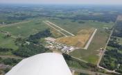
By: sunmanav8


