Login
Register


4B8
Robertson Field Airport
Official FAA Data Effective 2025-11-27 0901Z
Chart Supplement

VFR Chart of 4B8
Sectional Charts at SkyVector.com
IFR Chart of 4B8
Enroute Charts at SkyVector.com
Location Information for 4B8
Coordinates: N41°41.36' / W72°51.88'Located 02 miles N of Plainville, Connecticut on 39 acres of land. View all Airports in Connecticut.
Surveyed Elevation is 201 feet MSL.
TPA: 800 FT FOR ACFT LESS THAN 12500 LBS, 1300 FT FOR ACFT 12500 LBS & ABV.
Operations Data
|
|
Airport Communications
| AWOS-3PT: | 119.175 Tel. 860-351-5362 |
|---|---|
| BRADLEY APPROACH: | 123.95 290.55 |
| BRADLEY DEPARTURE: | 123.95 290.55 |
| CLEARANCE DELIVERY: | 134.5 |
| UNICOM: | 122.800 |
| CTAF: | 122.800 |
| AWOS-AV at CT71 (3.0 E): | 129.825 |
| ASOS at HFD (10.0 E): | 860-952-9954 |
| ATIS at HFD (10.1 E): | 126.45 |
- VFR ARPT. PVT OWNED/OPERD RTR FREQ 124.55 CTLD BY YANKEE APCH CTL TO PROVIDE CLEARANCE DELIVERY.
- APCH/DEP SVC PRVDD BY YANKEE APCH CNTL ON 123.95/290.55.
Nearby Navigation Aids
|
| ||||||||||||||||||||||||||||||||||||||||||||||||||||||||||||


Runway 02/20
| Dimensions: | 3666 x 75 feet / 1117 x 23 meters | |
|---|---|---|
| Surface: | Asphalt in Good Condition | |
| Weight Limits: | S-25 | |
| Edge Lighting: | Medium Intensity | |
| Runway 02 | Runway 20 | |
| Coordinates: | N41°41.06' / W72°51.92' | N41°41.66' / W72°51.84' |
| Elevation: | 188.9 | 201.6 |
| Traffic Pattern: | Left | Left |
| Runway Heading: | 5° True | 185° True |
| Markings: | Non-Precision Instrument in good condition. | Non-Precision Instrument in good condition. |
| Glide Slope Indicator | P2L (3.00° Glide Path Angle) | P2R (3.50° Glide Path Angle) |
| REIL: | Yes | Yes |
| Obstacles: | 17 ft Trees 250 ft from runway, 67 ft left of center 10 FT BRUSH, 15 FT DSTC, 90 FT L. |
50 ft Trees 240 ft from runway, 105 ft right of center |
Helipad H1
| Dimensions: | 30 x 30 feet / 9 x 9 meters | |
|---|---|---|
| Surface: | Asphalt in Good Condition | |
| Coordinates: | N41°41.42' / W72°51.89' | N0°0.00' / E0°0.00' |
| Elevation: | 200.0 | |
| Markings: | Basic in good condition. | |
Services Available
| Fuel: | 100LL (blue), Jet-A |
|---|---|
| Transient Storage: | Hangars,Tiedowns |
| Airframe Repair: | MAJOR |
| Engine Repair: | MAJOR |
| Bottled Oxygen: | HIGH/LOW |
| Bulk Oxygen: | NONE |
| Other Services: | CHARTER SERVICE,PILOT INSTRUCTION,AIRCRAFT RENTAL |
Ownership Information
| Ownership: | Publicly owned | |
|---|---|---|
| Owner: | TOWN OF PLAINVILLE | |
| 1 CENTRAL SQUARE | ||
| PLAINVILLE, CT 06062 | ||
| 860-793-0221 | ||
| Manager: | NICHOLAS SCATA | |
| 62 JOHNSON AVE | ||
| PLAINVILLE, CT 06062 | ||
| 860-747-5519 | ||
Other Remarks
- NOISE ABATEMENT PROCS IN EFCT. CTC 1-800-573-5519 OR 860-747-5519 FOR DTLS.
- FOR CD CTC BRADLEY APCH AT 860-386-3597.
- CTN DEER & BIRDS ON & INVOF ARPT.
- LDG FEE FOR COML AND CORPORATE ACFT ONLY.
- ACTVT REIL RWY 02 & 20; MIRL RWY 02/20 - CTAF. PAPI RWY 02 & 20 OPR CONSLY.
- TPA: 800 FT FOR ACFT LESS THAN 12500 LBS, 1300 FT FOR ACFT 12500 LBS & ABV.
Weather Minimums
Instrument Approach Procedure (IAP) Charts

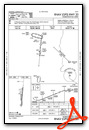
Nearby Airports with Instrument Procedures
| ID | Name | Heading / Distance | ||
|---|---|---|---|---|
 |
KHFD | Hartford-Brainard Airport | 073° | 10.1 |
|
KMMK | Meriden Markham Municipal Airport | 171° | 10.9 |
|
KBDL | Bradley International Airport | 028° | 17.0 |
|
KOXC | Waterbury-Oxford Airport | 223° | 17.6 |
|
KSNC | Chester Airport | 138° | 24.4 |
|
KHVN | Tweed/New Haven Airport | 182° | 25.5 |
|
KBAF | Westfield-Barnes Regional Airport | 013° | 28.9 |
|
KIJD | Windham Airport | 083° | 30.9 |
|
KDXR | Danbury Municipal Airport | 235° | 33.7 |
|
KCEF | Westover Arb/Metro Airport | 025° | 33.7 |
|
KBDR | Bridgeport/Sikorsky Airport | 200° | 33.7 |
|
KGBR | Walter J Koladza Airport | 321° | 38.2 |
Airport Images
Do you have a recent image of this airport? Upload it here!


