Login
Register


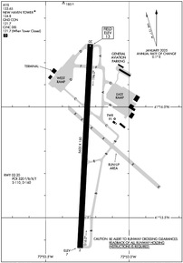
HVN
Tweed/New Haven Airport
Official FAA Data Effective 2026-01-22 0901Z
Chart Supplement

KHVN Airport Diagram
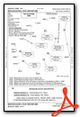
VFR Chart of KHVN
Sectional Charts at SkyVector.com
IFR Chart of KHVN
Enroute Charts at SkyVector.com
Location Information for KHVN
Coordinates: N41°15.82' / W72°53.26'Located 03 miles SE of New Haven, Connecticut on 394 acres of land. View all Airports in Connecticut.
Surveyed Elevation is 12 feet MSL.
TPA: 999 FT AGL RECIPROCATING ENG, 1499 FT AGL TURBOPROP/JET.
Operations Data
|
|
Airport Communications
| ATIS: | 133.65 |
|---|---|
| ASOS: | Tel. 203-466-6205 |
| NEW HAVEN TOWER: | 124.8 |
| NEW HAVEN GROUND: | 121.7 |
| NEW YORK APPROACH: | 124.075 343.65 |
| NEW YORK DEPARTURE: | 124.075 343.65 |
| CLEARANCE DELIVERY: | 121.7 121.7 ;WHEN HVN TWR CLSD |
| DENNA STAR: | 124.075 343.65 |
| UNICOM: | 122.950 |
| CTAF: | 124.800 |
| ASOS at BDR (12.3 SW): | 119.15 203-381-9453 |
| ATIS at BDR (12.3 SW): | 119.15 |
| ASOS at MMK (14.9 N): | 134.925 203-639-9405 |
Nearby Navigation Aids
|
| ||||||||||||||||||||||||||||||||||||||||||||||||||||||||||||


Runway 02/20
| Dimensions: | 5600 x 150 feet / 1707 x 46 meters | |
|---|---|---|
| Surface: | Asphalt / Grooved in Excellent Condition | |
| Weight Limits: | S-110, D-160
PCR VALUE: 320/F/B/X/T
| |
| Edge Lighting: | High Intensity | |
| Runway 02 | Runway 20 | |
| Coordinates: | N41°15.36' / W72°53.29' | N41°16.28' / W72°53.23' |
| Elevation: | 6.5 | 12.6 |
| Traffic Pattern: | Left | Left |
| Runway Heading: | 3° True | 183° True |
| Declared Distances: | TORA:5600 TODA:5600 ASDA:5600 LDA:5600 | TORA:5600 TODA:5600 ASDA:5600 LDA:5600 |
| Markings: | Precision Instrument in good condition. | Non-Precision Instrument in good condition. |
| Glide Slope Indicator | P4L (3.00° Glide Path Angle) | P4L (3.50° Glide Path Angle) |
| RVR Equipment | Touchdown | Rollout |
| Approach Lights: | MALSF 1,400 Foot Medium-intensity Approach Lighting System with sequenced flashers. | |
| Obstacles: | 36 ft Trees 1400 ft from runway | 55 ft Trees 1300 ft from runway |
Services Available
| Fuel: | 100LL (blue), Jet-A |
|---|---|
| Transient Storage: | Hangars,Tiedowns |
| Airframe Repair: | MAJOR |
| Engine Repair: | MAJOR |
| Bottled Oxygen: | HIGH |
| Bulk Oxygen: | HIGH |
| Other Services: | CHARTER SERVICE,PILOT INSTRUCTION,AIRCRAFT RENTAL,AIRCRAFT SALES |
Ownership Information
| Ownership: | Publicly owned | |
|---|---|---|
| Owner: | CITY OF NEW HAVEN | |
| 155 BURR ST | ||
| NEW HAVEN, CT 06510 | ||
| 203-466-8833 | ||
| Manager: | JEREMY NIELSON | |
| 155 BURR ST | ||
| NEW HAVEN, CT 06512 | ||
| 203-466-8833 | ||
Other Remarks
- NOISE ABATEMENT PROCS IN EFCT. DEPARTING RWY 20, RIGHT AND LEFT TURN MADE ONLY AFT PASSING SHORELINE.
- WILDLIFE FQTLY ON OR INVOF ARPT.
- TSNT PRKG ON EAST RAMP ONLY.
- PAEW ADJ TO ALL OPR SFCS DALGT HRS APR-OCT.
- LDG HELS USE TWYS A & H INTXN.
- STANDING WATER AT INTXN OF TWY D & C AFT HVY RAIN.
- FOR CD WHEN TWR CLSD CTC NEW YORK APCH AT 516-683-2449 OR 121.7.
- TGL OPNS PMTD 0700-2200 MON-SAT; 0800-2200 SUN.
- AVOID CLOSE-IN BASE LEGS AND SHORT APCHS LDG RWY 20.
- FLT NOTIFICATION SVC (ADCUS) AVBL.
- CLSD TO ACFT OVER 78 DB 0700-2200; 73 DB 2200-0000 & 0600-0700; 68 DB 0000-0600 EXCP MIL EMERG & MED ACFT; PPR CALL 203-907-9818.
- EXTSV HOP SFC-10000 FT WI 20 MI NNW.
- WHEN ATCT CLSD ACTVT MALSF RWY 02; HIRL RWY 02/20 - CTAF.
- TPA: 999 FT AGL RECIPROCATING ENG, 1499 FT AGL TURBOPROP/JET.
Weather Minimums

Standard Terminal Arrival (STAR) Charts
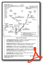
Instrument Approach Procedure (IAP) Charts
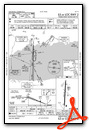
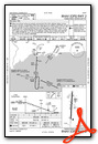
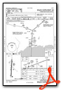
Departure Procedure (DP) Charts
Nearby Airports with Instrument Procedures
| ID | Name | Heading / Distance | ||
|---|---|---|---|---|
 |
KBDR | Bridgeport/Sikorsky Airport | 240° | 12.4 |
|
KMMK | Meriden Markham Municipal Airport | 010° | 14.9 |
|
KOXC | Waterbury-Oxford Airport | 319° | 17.0 |
|
KSNC | Chester Airport | 067° | 18.7 |
|
4B8 | Robertson Field Airport | 002° | 25.5 |
|
KHWV | Brookhaven Airport | 177° | 26.5 |
|
KDXR | Danbury Municipal Airport | 283° | 27.6 |
|
KFOK | Francis S Gabreski Airport | 155° | 27.7 |
|
KISP | Long Island Mac Arthur Airport | 199° | 29.7 |
|
KHFD | Hartford-Brainard Airport | 020° | 30.3 |
 |
87N | Southampton Heliport | 142° | 31.5 |
|
KJPX | East Hampton Town Airport | 122° | 34.1 |


