Login
Register


4J1
Brantley County Airport
Official FAA Data Effective 2026-01-22 0901Z
Chart Supplement

VFR Chart of 4J1
Sectional Charts at SkyVector.com
IFR Chart of 4J1
Enroute Charts at SkyVector.com
Location Information for 4J1
Coordinates: N31°12.36' / W81°54.36'Located 04 miles E of Nahunta, Georgia on 174 acres of land. View all Airports in Georgia.
Surveyed Elevation is 84 feet MSL.
Operations Data
|
|
Airport Communications
| CTAF: | 122.900 |
|---|---|
| AWOS-3PT at JES (20.8 N): | 118.125 912-427-0855 |
| AWOS-3 at BQK (22.3 E): | 124.175 912-261-0531 |
| AWOS-3PT at WX3 (22.6 E): | 124.175 |
- APCH/DEP SVC PRVDD BY JACKSONVILLE ARTCC ON FREQS 127.575/269.025 (ALMA RCAG).
Nearby Navigation Aids
|
| ||||||||||||||||||||||||||||||||||||||||||||||||||||||||||||


Runway 01/19
| Dimensions: | 4000 x 75 feet / 1219 x 23 meters | |
|---|---|---|
| Surface: | Asphalt in Good Condition | |
| Weight Limits: | S-14 | |
| Edge Lighting: | Medium Intensity | |
| Runway 01 | Runway 19 | |
| Coordinates: | N31°12.04' / W81°54.40' | N31°12.69' / W81°54.32' |
| Elevation: | 80.5 | 80.7 |
| Traffic Pattern: | Left | Left |
| Runway Heading: | 6° True | 186° True |
| Displaced Threshold: | 700 Feet | |
| Markings: | Non-Precision Instrument in good condition. | Non-Precision Instrument in good condition. |
| Glide Slope Indicator | P2L (3.00° Glide Path Angle) | P2L (3.00° Glide Path Angle) |
| Obstacles: | 20 ft Trees 201 ft from runway, 240 ft right of center | 86 ft Trees 1060 ft from runway, 355 ft right of center |
Services Available
| Fuel: | NONE |
|---|---|
| Transient Storage: | Tiedowns |
| Airframe Repair: | NONE |
| Engine Repair: | NONE |
| Bottled Oxygen: | NONE |
| Bulk Oxygen: | NONE |
Ownership Information
| Ownership: | Publicly owned | |
|---|---|---|
| Owner: | BRANTLEY COUNTY | |
| 33 ALLEN RD, PO BOX 398, 117 BRANTLY STREET | ||
| NAHUNTA, GA 31553 | ||
| 912-462-5256 | ||
| Manager: | JOEY CASON | |
| 33 ALLEN RD, PO BOX 792 | ||
| NAHUNTA, GA 31553 | ||
| (912) 462-5256 | ||
Other Remarks
- FOR CD CTC JACKSONVILLE ARTCC AT 904-845-1592.
- ACTVT PAPI RWY 01 & 19; MIRL RWY 01/19 - CTAF.
Weather Minimums

Instrument Approach Procedure (IAP) Charts
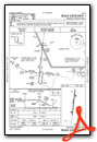
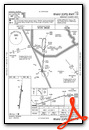
Nearby Airports with Instrument Procedures
| ID | Name | Heading / Distance | ||
|---|---|---|---|---|
 |
KJES | Jesup-Wayne County Airport | 003° | 20.9 |
|
KBQK | Brunswick Golden Isles Airport | 081° | 22.8 |
|
KAYS | Waycross-Ware County Airport | 275° | 25.3 |
|
09J | Jekyll Island Airport | 107° | 25.9 |
|
KSSI | St Simons Island Airport | 096° | 26.7 |
|
KAMG | Bacon County Airport | 302° | 36.6 |
|
KBHC | Baxley Municipal Airport | 320° | 39.4 |
|
KFHB | Fernandina Beach Municipal Airport | 147° | 42.3 |
|
KJAX | Jacksonville International Airport | 165° | 44.1 |
|
KLHW | Wright AAF (Fort Stewart)/Midcoast Regional Airport | 023° | 44.5 |
|
KHOE | Homerville Airport | 258° | 45.6 |
|
KDQH | Douglas Municipal Airport | 288° | 51.7 |
Airport Images
Do you have a recent image of this airport? Upload it here!


