Login
Register
09J
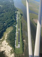
Jekyll Island Airport
Official FAA Data Effective 2026-02-19 0901Z
VFR Chart of 09J
Sectional Charts at SkyVector.com
IFR Chart of 09J
Enroute Charts at SkyVector.com
Location Information for 09J
Coordinates: N31°4.47' / W81°25.67'Located 06 miles SE of Jekyll Island, Georgia on 100 acres of land. View all Airports in Georgia.
Surveyed Elevation is 11 feet MSL.
Operations Data
|
|
Airport Communications
| CTAF: | 123.050 |
|---|---|
| UNICOM: | 123.050 |
| AWOS-3PT at SSI (5.2 NE): | 120.025 912-602-0972 |
| AWOS-3 at BQK (11.2 N): | 124.175 912-261-0531 |
| AWOS-3PT at WX3 (11.3 N): | 124.175 |
- APCH/DEP SVC PRVDD BY JACKSONVILLE ARTCC (ZJX) ON FREQS 126.75/277.4 (BRUNSWICK RCAG).
Nearby Navigation Aids
|
| ||||||||||||||||||||||||||||||||||||||||||||||||||||||||||||
Runway 18/36
| Dimensions: | 3715 x 75 feet / 1132 x 23 meters | |
|---|---|---|
| Surface: | Asphalt in Good Condition | |
| Weight Limits: | S-20 | |
| Edge Lighting: | Medium Intensity | |
| Runway 18 | Runway 36 | |
| Coordinates: | N31°4.77' / W81°25.70' | N31°4.16' / W81°25.63' |
| Elevation: | 11.0 | 11.0 |
| Traffic Pattern: | Right | Left |
| Runway Heading: | 174° True | 354° True |
| Declared Distances: | TORA:3715 TODA:3715 ASDA:3575 LDA:3575 | TORA:3715 TODA:3715 ASDA:3715 LDA:3575 |
| Markings: | Non-Precision Instrument in good condition. | Non-Precision Instrument in good condition. |
| Glide Slope Indicator | P2L (3.00° Glide Path Angle) | P2L (3.25° Glide Path Angle) |
| Obstacles: | 54 ft Trees 201 ft from runway, 230 ft right of center | |
Services Available
| Fuel: | 100LL (blue) |
|---|---|
| Transient Storage: | Tiedowns |
| Airframe Repair: | NONE |
| Engine Repair: | NONE |
| Bottled Oxygen: | NONE |
| Bulk Oxygen: | NONE |
Ownership Information
| Ownership: | Publicly owned | |
|---|---|---|
| Owner: | JEKYLL ISLAND AUTHORITY | |
| 100 JAMES RD. | ||
| JEKYLL ISLAND, GA 31527 | ||
| 912-635-4000 | ||
| Manager: | NOEL JENSEN | JEKYLL ISLAND AUTHORITY. |
| 100 JAMES ROAD | ||
| JEKYLL ISLAND, GA 31527 | ||
| 912-635-9330 | ||
Other Remarks
- TRANSITION VIOLATIONS - 55 FT TREES E OF RY & 40 FT TREES W OF RY.
- ROTG BCN IS LCTD ON TOP OF A WATER TANK 1/2 - 1 MILE NE OF RY 18 IN A SWAMPY AREA.
- DEER ON & INVOF OF ARPT.
- FOR CD CTC JACKSONVILLE ARTCC AT 904-845-1592.
- ACTVT MIRL RY 18/36 AND PAPI RY 18 & RY 36 - CTAF.
Weather Minimums
Instrument Approach Procedure (IAP) Charts
Nearby Airports with Instrument Procedures
| ID | Name | Heading / Distance | ||
|---|---|---|---|---|
 |
KSSI | St Simons Island Airport | 022° | 5.0 |
 |
KBQK | Brunswick Golden Isles Airport | 349° | 11.2 |
 |
4J1 | Brantley County Airport | 287° | 25.9 |
 |
KFHB | Fernandina Beach Municipal Airport | 183° | 27.7 |
 |
KJES | Jesup-Wayne County Airport | 320° | 37.0 |
 |
KJAX | Jacksonville International Airport | 201° | 37.3 |
 |
KNRB | Mayport Ns (Adm David L Mcdonald Field) Airport | 179° | 40.9 |
 |
KCRG | Jacksonville Exec At Craig Airport | 185° | 44.4 |
 |
KLHW | Wright AAF (Fort Stewart)/Midcoast Regional Airport | 351° | 49.2 |
 |
KAYS | Waycross-Ware County Airport | 282° | 50.9 |
 |
KHEG | Herlong Recreational Airport | 202° | 51.5 |
 |
KNIP | Jacksonville NAS (Towers Field) Airport | 194° | 51.9 |


Comments
Jekyll Island
We flew in for a few days at the beach. On arrival, we met John who was one of the nicest guys you'll meet in an FBO. He had our RedBug electric car ready and waiting for us which I have to say is the only way to travel. Great idea. John gave us a few pointers for food and we were off. The Jekyll airport has a little "burble" as you descend below the trees so watch out! Other than that, I give Jekyll an A+.
William Chapman
Pages