Login
Register


JES
Jesup-Wayne County Airport
Official FAA Data Effective 2026-01-22 0901Z
Chart Supplement

VFR Chart of KJES
Sectional Charts at SkyVector.com
IFR Chart of KJES
Enroute Charts at SkyVector.com
Location Information for KJES
Coordinates: N31°33.24' / W81°52.95'Located 03 miles S of Jesup, Georgia on 139 acres of land. View all Airports in Georgia.
Surveyed Elevation is 107 feet MSL.
Operations Data
|
|
Airport Communications
| AWOS-3PT: | 118.125 Tel. 912-427-0855 |
|---|---|
| CTAF: | 122.800 |
| UNICOM: | 122.800 |
| ATIS at LHW (25.9 NE): | 118.475 |
| AWOS-3 at BQK (27.5 SE): | 124.175 912-261-0531 |
| AWOS-3PT at WX3 (27.5 SE): | 124.175 |
- APCH/DEP SVC PRVDD BY JACKSONVILLE ARTCC (ZJX) ON FREQS 126.75/277.4 (BRUNSWICK RCAG).
Nearby Navigation Aids
|
| ||||||||||||||||||||||||||||||||||||||||||||||||||||||||||||


Runway 11/29
| Dimensions: | 5500 x 100 feet / 1676 x 30 meters | |
|---|---|---|
| Surface: | Asphalt in Good Condition | |
| Weight Limits: | S-21 | |
| Edge Lighting: | Medium Intensity | |
| Runway 11 | Runway 29 | |
| Coordinates: | N31°33.31' / W81°53.47' | N31°33.16' / W81°52.43' |
| Elevation: | 107.3 | 69.7 |
| Traffic Pattern: | Left | Left |
| Runway Heading: | 99° True | 279° True |
| Markings: | Non-Precision Instrument in fair condition. | Non-Precision Instrument in fair condition. |
| Glide Slope Indicator | P2L (3.75° Glide Path Angle) | P2L (3.00° Glide Path Angle) |
| Approach Lights: | MALSF 1,400 Foot Medium-intensity Approach Lighting System with sequenced flashers. | |
| Obstacles: | 99 ft Trees 1883 ft from runway, 73 ft left of center | 30 ft Trees 1070 ft from runway, 369 ft right of center |
Services Available
| Fuel: | 100LL (blue), Jet A+ |
|---|---|
| Transient Storage: | Tiedowns |
| Airframe Repair: | MAJOR |
| Engine Repair: | MAJOR |
| Bottled Oxygen: | NONE |
| Bulk Oxygen: | NONE |
| Other Services: | PILOT INSTRUCTION,AIRCRAFT RENTAL,AIRCRAFT SALES |
Ownership Information
| Ownership: | Publicly owned | |
|---|---|---|
| Owner: | WAYNE COUNTY | |
| PO BOX 270 | ||
| JESUP, GA 31598 | ||
| 912-427-5900 | ||
| Manager: | MITCH SUTTON | |
| 535 AIRPORT ROAD | ||
| JESUP, GA 31546 | ||
| 912-266-2234 | ARPT PHONE 912-427-5949. | |
Other Remarks
- FOR CD CTC JACKSONVILLE ARTCC AT 904-845-1592.
- ACTVT MIRL RY 11/29; PAPI RY 11; PAPI RY 29 & MALSF RY 29 - CTAF.
Weather Minimums

Instrument Approach Procedure (IAP) Charts

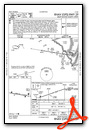
Nearby Airports with Instrument Procedures
| ID | Name | Heading / Distance | ||
|---|---|---|---|---|
 |
4J1 | Brantley County Airport | 183° | 20.9 |
|
KLHW | Wright AAF (Fort Stewart)/Midcoast Regional Airport | 039° | 25.8 |
|
KBQK | Brunswick Golden Isles Airport | 129° | 27.7 |
|
KBHC | Baxley Municipal Airport | 290° | 27.9 |
|
KAMG | Bacon County Airport | 268° | 32.0 |
|
KAYS | Waycross-Ware County Airport | 235° | 32.1 |
|
KRVJ | Swinton Smith Field At Reidsville Municipal Airport | 335° | 33.3 |
|
KSSI | St Simons Island Airport | 133° | 34.9 |
|
09J | Jekyll Island Airport | 140° | 37.0 |
|
KCWV | Claxton-Evans County Airport | 001° | 38.4 |
|
KAZE | Hazlehurst Airport | 297° | 43.9 |
|
KVDI | Vidalia Regional Airport | 326° | 45.7 |
Airport Images
Do you have a recent image of this airport? Upload it here!


