Login
Register


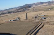
4S7
Malin Airport
Official FAA Data Effective 2025-12-25 0901Z
Chart Supplement

VFR Chart of 4S7
Sectional Charts at SkyVector.com
IFR Chart of 4S7
Enroute Charts at SkyVector.com
Location Information for 4S7
Coordinates: N42°0.07' / W121°23.78'Located 01 miles SE of Malin, Oregon on 97 acres of land. View all Airports in Oregon.
Estimated Elevation is 4053 feet MSL.
Operations Data
|
|
Airport Communications
| CTAF: | 122.900 |
|---|---|
| ASOS at LMT (17.1 NW): | 541-883-8127 |
| ATIS at LMT (17.7 NW): | 263.0 |
| AWOS-3PT at LKV (45.5 E): | 135.525 541-947-5069 |
Nearby Navigation Aids
|
| ||||||||||||||||||||||||||||||||||||||||||


Runway 14/32
| Dimensions: | 2800 x 30 feet / 853 x 9 meters | |
|---|---|---|
| Surface: | Asphalt in Good Condition | |
| Runway 14 | Runway 32 | |
| Coordinates: | N42°0.28' / W121°23.90' | N41°59.85' / W121°23.67' |
| Elevation: | 4053.0 | 4051.0 |
| Traffic Pattern: | Left | Left |
| Runway Heading: | 158° True | 338° True |
| Markings: | Non-Standard in fair condition. | Non-Standard in fair condition. |
| Obstacles: | +4 FENCE ON CNTRLN AT 100 FT. |
17 ft Road 200 ft from runway RY 32 16:1 APRCH SLOPE TO THE DSPLCD THLD. RY 32 5 FT GATE 190 FT FROM RY END 50FT RIGHT. |
Services Available
| Fuel: | 100LL (blue) |
|---|---|
| Transient Storage: | Tiedowns |
| Airframe Repair: | NONE |
| Engine Repair: | NONE |
| Bottled Oxygen: | NONE |
| Bulk Oxygen: | NONE |
| Other Services: | CROP DUSTING SERVICES |
Ownership Information
| Ownership: | Publicly owned | |
|---|---|---|
| Owner: | CITY OF MALIN | |
| CITY HALL, BOX 61 | ||
| MALIN, OR 97632 | ||
| 541-723-2021 | ||
| Manager: | ROBBIE GROUNDS | |
| CITY HALL BOX 61 | ||
| MALIN, OR 96732 | ||
| 541-892-1572 | ||
Other Remarks
- PARKING APRON NOT EQUIPPED WITH TIE DOWNS
- TAXIWAY NOT MARKED WITH CENTERLINE
- FOR CD CTC SEATTLE ARTCC AT 253-351-3694.
- REMOTE CTLD ACFT IN VCNTY.
- RY 14 NUMBERS SMALLER THAN STANDARD; RY HAS NO CNTRLN.
- RUNWAY 32 HAS NON-STANDARD DISPLACED THRESHOLD MARKINGS.
- RY 32 NUMBERS SMALLER THAN STANDARD; RY HAS NO CNTRLN; RY THLD MRKD WITH WHITE CHEVRONS.
Nearby Airports with Instrument Procedures
| ID | Name | Heading / Distance | ||
|---|---|---|---|---|
 |
KLMT | Crater Lake/Klamath Regional Airport | 301° | 17.7 |
|
KLKV | Lake County Airport | 077° | 45.6 |
|
KAAT | Alturas Municipal Airport | 129° | 48.6 |
|
O46 | Weed Airport | 237° | 56.9 |
|
KMFR | Rogue Valley International/Medford Airport | 289° | 69.6 |
|
62S | Christmas Valley Airport | 023° | 80.9 |
|
3S8 | Grants Pass Airport | 289° | 93.8 |
|
O85 | Benton Field Airport | 208° | 97.0 |
|
KRDD | Redding Regional Airport | 204° | 98.3 |
|
O05 | Rogers Field Airport | 176° | 103.3 |
|
KSVE | Susanville Municipal Airport | 158° | 104.4 |
|
S21 | Sunriver Airport | 358° | 112.5 |
Airport Images

By: skitheo
By: skitheo


