Login
Register


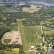
4Y1
Raether Airport
Official FAA Data Effective 2024-11-28 0901Z
Chart Supplement

VFR Chart of 4Y1
Sectional Charts at SkyVector.com
IFR Chart of 4Y1
Enroute Charts at SkyVector.com
Location Information for 4Y1
Coordinates: N42°33.92' / W83°51.38'Located 06 miles SE of Howell, Michigan on 10 acres of land. View all Airports in Michigan.
Estimated Elevation is 984 feet MSL.
Operations Data
|
|
Airport Communications
| CTAF: | 122.900 |
|---|---|
| AWOS-3 at OZW (6.8 NW): | 118.875 517-546-4450 |
| ASOS at PTK (20.2 E): | 125.025 248-886-8551 |
| ATIS at PTK (20.2 E): | 125.025 |
Nearby Navigation Aids
|
| ||||||||||||||||||||||||||||||||||||||||||||||||||||||||||||


Runway 17/35
| Dimensions: | 2206 x 70 feet / 672 x 21 meters | |
|---|---|---|
| Surface: | Turf in Fair Condition | |
| Runway 17 | Runway 35 | |
| Coordinates: | N42°34.09' / W83°51.45' | N42°33.74' / W83°51.31' |
| Elevation: | 984.0 | 983.0 |
| Runway Heading: | 164° True | 344° True |
| Displaced Threshold: | 757 Feet | 740 Feet |
| Obstacles: | 85 ft Trees 484 ft from runway APCH RATIO 18:1 TO DTHR OVR +85 FT TREE, 1534 FT DIST, 0 FT B. |
15 ft Road 0 ft from runway, 55 ft left of center APCH RATIO 19:1 TO DTHR OVR +90 FT TREE, 1739 FT DIST, 20 FT L. |
Ownership Information
| Ownership: | Privately Owned | |
|---|---|---|
| Owner: | RODNEY F & JUDY E RAETHER | |
| 2650 FISHBECK RD | ||
| HOWELL, MI 48843-8809 | ||
| 517-546-4498 | ||
| Manager: | RODNEY F RAETHER | |
| 2650 FISHBECK RD | ||
| HOWELL, MI 48843-8809 | ||
| 517-546-4498 | ||
Other Remarks
- HVY EQPT ADJ TO WEST SIDE OF RWY 35.
- DEER & LRG BIRDS ON & INVOF ARPT.
- ULTRALIGHT ACT ON & INVOF ARPT.
- FOR CD CTC DETROIT APCH AT 734-955-1404.
- RWY & DTHR MKD WITH 3 FT YELLOW CONES.
- RWY & DTHR MKD WITH 3 FT YELLOW CONES.
Nearby Airports with Instrument Procedures
| ID | Name | Heading / Distance | ||
|---|---|---|---|---|
 |
KOZW | Livingston County Spencer J Hardy Airport | 304° | 6.8 |
|
Y47 | Oakland Southwest Airport | 109° | 11.0 |
|
9G2 | Prices Airport | 014° | 15.0 |
|
KPTK | Oakland County International Airport | 072° | 20.2 |
|
KARB | Ann Arbor Municipal Airport | 166° | 21.1 |
|
1D2 | Canton-Plymouth-Mettetal Airport | 126° | 22.0 |
|
KYIP | Willow Run Airport | 143° | 24.3 |
|
KFNT | Bishop International Airport | 011° | 24.5 |
|
KTEW | Mason Jewett Field Airport | 270° | 25.1 |
|
KRNP | Owosso Community Airport | 334° | 28.5 |
|
KVLL | Oakland/Troy Airport | 092° | 30.1 |
|
KDTW | Detroit Metro Wayne County Airport | 133° | 30.8 |
Airport Images
By: 15zenderb


