Login
Register


YIP
Willow Run Airport
Official FAA Data Effective 2026-01-22 0901Z
Chart Supplement

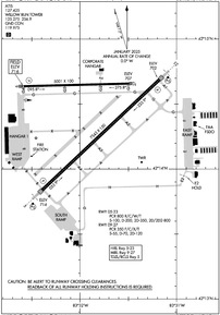
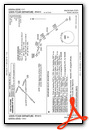
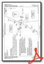
KYIP Airport Diagram
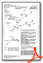
VFR Chart of KYIP
Sectional Charts at SkyVector.com
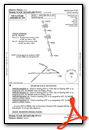
IFR Chart of KYIP
Enroute Charts at SkyVector.com
Location Information for KYIP
Coordinates: N42°14.42' / W83°31.89'Located 24 miles SW of Detroit, Michigan on 2392 acres of land. View all Airports in Michigan.
Surveyed Elevation is 715 feet MSL.
Operations Data
|
|
Airport Communications
| ATIS: | 127.425 (734-961-6844) |
|---|---|
| ASOS: | Tel. 734-961-6843 |
| WILLOW RUN TOWER: | 125.275 256.9 |
| WILLOW RUN GROUND: | 119.975 |
| DETROIT APPROACH: | 118.95 284.0 |
| DETROIT DEPARTURE: | 118.95 284.0 |
| METRO DP: | 118.95 ;WESTBOUND 134.3 ;EASTBOUND 284.0 |
| ASOS at DTW (8.1 E): | 231-202-2054 |
| D-ATIS at DTW (8.1 E): | 118.125 ;DEP |
| ASOS at ARB (9.6 W): | 734-668-7173 |
- EMERG FREQS NOT AVBL AT TWR.
Nearby Navigation Aids
|
| ||||||||||||||||||||||||||||||||||||||||||||||||||||||||||||


Runway 05/23
| Dimensions: | 7543 x 150 feet / 2299 x 46 meters | |
|---|---|---|
| Surface: | Concrete / Grooved in Good Condition | |
| Weight Limits: | S-100, D-200, ST-350, DT-800
PCR VALUE: 800/R/C/W/T
| |
| Edge Lighting: | High Intensity | |
| Runway 05 | Runway 23 | |
| Coordinates: | N42°13.84' / W83°32.39' | N42°14.69' / W83°31.17' |
| Elevation: | 714.3 | 701.5 |
| Traffic Pattern: | Left | Left |
| Runway Heading: | 47° True | 227° True |
| Declared Distances: | TORA:7543 TODA:7543 ASDA:7543 LDA:7543 | TORA:7543 TODA:7543 ASDA:7543 LDA:7543 |
| Markings: | Precision Instrument in good condition. | Precision Instrument in good condition. |
| Glide Slope Indicator | P4L (3.00° Glide Path Angle) | P4L (3.00° Glide Path Angle) |
| RVR Equipment | Touchdown | Rollout |
| Approach Lights: | MALSR 1,400 Foot Medium-intensity Approach Lighting System with runway alignment indicator lights. | MALSR 1,400 Foot Medium-intensity Approach Lighting System with runway alignment indicator lights. |
| Centerline Lights: | Yes | Yes |
| Obstacles: | 74 ft Tree 2434 ft from runway, 817 ft right of center | 39 ft Tree 1387 ft from runway, 674 ft right of center |
Runway 09/27
| Dimensions: | 5001 x 100 feet / 1524 x 30 meters | |
|---|---|---|
| Surface: | Asphalt / Grooved in Excellent Condition ONLY THE 80' CENTER PORTION OF THE RY IS GRVD. | |
| Weight Limits: | S-55, D-70, ST-120
PCR VALUE: 350/F/C/X/T
| |
| Edge Lighting: | Medium Intensity | |
| Runway 09 | Runway 27 | |
| Coordinates: | N42°14.64' / W83°32.60' | N42°14.66' / W83°31.49' |
| Elevation: | 715.9 | 706.9 |
| Traffic Pattern: | Left | Left |
| Runway Heading: | 89° True | 269° True |
| Declared Distances: | TORA:5001 TODA:5001 ASDA:5001 LDA:5001 | TORA:5001 TODA:5001 ASDA:5001 LDA:5001 |
| Markings: | Non-Precision Instrument in good condition. | Non-Precision Instrument in good condition. |
| Glide Slope Indicator | P4L (3.00° Glide Path Angle) | |
Services Available
| Fuel: | 100LL (blue), Jet-A |
|---|---|
| Transient Storage: | Hangars,Tiedowns |
| Airframe Repair: | MAJOR |
| Engine Repair: | MAJOR |
| Bottled Oxygen: | HIGH |
| Bulk Oxygen: | HIGH |
| Other Services: | AIR FREIGHT SERVICES,AVIONICS,CARGO HANDLING SERVICES,CHARTER SERVICE,PILOT INSTRUCTION,AIRCRAFT RENTAL,AIRCRAFT SALES |
Ownership Information
| Ownership: | Publicly owned | |
|---|---|---|
| Owner: | WAYNE COUNTY AIRPORT AUTHORITY | |
| 11050 ROGELL DR # 602 | ||
| DETROIT, MI 48242-1144 | ||
| 734-485-6666 | ||
| Manager: | MICHAEL FAWAZ | |
| 47763 A ST | ||
| VAN BUREN TOWNSHIP, MI 48111-1271 | ||
| 734-485-6670 | ||
Other Remarks
- BIRDS ON & INVOF ARPT.
- CLSD TO SKEDD ACR OPS GTR THAN 9 PSGR SEATS. 72 HRS PPR FOR UNSKED ACR OPS WITH MORE THAN 30 PSGR SEATS CALL ARPT OPS MGR 734-485-6670.
- LRA ARPT; ADCUS 734-942-9000.
- CUST AVBL 24 HRS, MON - FRI AND ON CALL FROM DTW ON WKEND.
- HELICOPTER TKOFS & LDGS ON THE SOUTH RAMP PROHIBITED, TAXI ONLY.
- CONDS NOT MNT OUTSIDE M-F, 0800-1600,DTW AIRFIELD OPS (734-942-3685) PROVIDES DLY INSPECTIONS AND IS ON CALL FOR WX OR INCIDENTS OFF HRS.
- WRONG SFC ARR RISK ARPT, CLOSELY ALIGNED PAVEMENT TXY G & RWY 09/27.
- AND WASHTENAW CO.
- FOR CUSTOMS CLNC 1 HR MIN ADVANCE NOTIFICATION REQD. PILOTS MUST CTC U.S. CUSTOMS ON 313-226-3140; RQ FOR CUSTOMS SVC BY FAA FLIGHT PLAN IS NOT ACCEPTED.
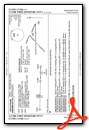
Weather Minimums

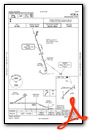
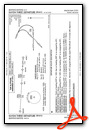
Standard Terminal Arrival (STAR) Charts
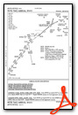

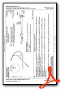
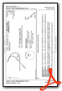
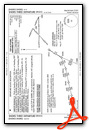
Instrument Approach Procedure (IAP) Charts


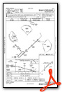


Departure Procedure (DP) Charts


Nearby Airports with Instrument Procedures
| ID | Name | Heading / Distance | ||
|---|---|---|---|---|
 |
1D2 | Canton-Plymouth-Mettetal Airport | 027° | 7.3 |
|
KDTW | Detroit Metro Wayne County Airport | 101° | 8.1 |
|
KARB | Ann Arbor Municipal Airport | 263° | 9.6 |
|
Y47 | Oakland Southwest Airport | 345° | 16.3 |
|
KONZ | Grosse Ile Municipal Airport | 117° | 18.6 |
|
KTTF | Custer Airport | 166° | 18.5 |
|
KVLL | Oakland/Troy Airport | 040° | 24.0 |
|
KDET | Coleman A Young Municipal Airport | 065° | 25.4 |
|
CYQG | Windsor Airport | 085° | 25.7 |
|
KPTK | Oakland County International Airport | 010° | 26.0 |
|
KOZW | Livingston County/Spencer J Hardy Airport | 319° | 30.8 |
|
KDUH | Toledo Suburban Airport | 190° | 30.8 |
Fuel Providers


We proudly offer fuel from:

US Dollar per US Gallon
Price Guaranteed by FBO

Airport Images
Do you have a recent image of this airport? Upload it here!


