Login
Register


PTK
Oakland County International Airport
Official FAA Data Effective 2026-01-22 0901Z
Chart Supplement

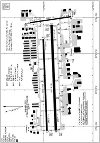
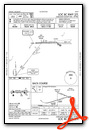
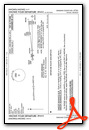
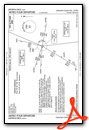
KPTK Airport Diagram
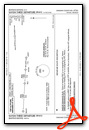
VFR Chart of KPTK
Sectional Charts at SkyVector.com
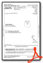
IFR Chart of KPTK
Enroute Charts at SkyVector.com
Location Information for KPTK
Coordinates: N42°39.94' / W83°25.23'Located 05 miles W of Pontiac, Michigan on 750 acres of land. View all Airports in Michigan.
Surveyed Elevation is 980 feet MSL.
Operations Data
|
|
Airport Communications
| ATIS: | 125.025 |
|---|---|
| ASOS: | 125.025 Tel. 248-886-8551 |
| PONTIAC TOWER: | 120.5 123.7 |
| PONTIAC GROUND: | 121.65 121.9 |
| DETROIT APPROACH: | 132.35 284.0 |
| DETROIT DEPARTURE: | 132.35 284.0 |
| CLEARANCE DELIVERY: | 118.25 |
| RRALF STAR: | 284.0 |
| PETTE STAR: | 118.95 284.0 |
| CTAF: | 120.500 |
| OKLND STAR: | 284.0 |
| UNICOM: | 122.950 |
| FOREY STAR: | 134.3 284.0 |
| AWOS-3 at VLL (13.0 SE): | 119.475 248-288-4649 |
| ATIS at FNT (23.0 NW): | 133.15 |
| ASOS at FNT (23.4 NW): | 810-202-2914 |
Nearby Navigation Aids
|
| ||||||||||||||||||||||||||||||||||||||||||||||||||||||||||||


Runway 09R/27L
| Dimensions: | 6521 x 150 feet / 1988 x 46 meters | |
|---|---|---|
| Surface: | Asphalt / Grooved in Excellent Condition | |
| Weight Limits: | S-120, D-219, ST-404
PCR VALUE: 400/F/A/X/T
| |
| Edge Lighting: | High Intensity | |
| Runway 09R | Runway 27L | |
| Coordinates: | N42°39.88' / W83°26.06' | N42°39.92' / W83°24.61' |
| Elevation: | 980.4 | 971.5 |
| Traffic Pattern: | Left | Left |
| Runway Heading: | 88° True | 268° True |
| Declared Distances: | TORA:6520 TODA:6520 ASDA:6520 LDA:6520 | TORA:6520 TODA:6520 ASDA:6520 LDA:6520 |
| Markings: | Precision Instrument in fair condition. | Precision Instrument in fair condition. |
| Glide Slope Indicator | P4L (3.00° Glide Path Angle) | P4L (3.00° Glide Path Angle) PAPI UNUSBL BYD 8 DEGS RIGHT OF CNTRLN. |
| RVR Equipment | Touchdown | Rollout |
| Approach Lights: | MALSR 1,400 Foot Medium-intensity Approach Lighting System with runway alignment indicator lights. | |
| REIL: | Yes | |
Runway 09L/27R
RWY 09L/27R NOT AVBL FOR PART 121/PART 380 OPS WITH SKED PAX CARRYING OPS MORE THAN 9 PAX SEATS AND NON-SKED PAX CARRYING OPS MORE THAN 30 PAX SEATS. | ||
| Dimensions: | 5676 x 100 feet / 1730 x 30 meters | |
|---|---|---|
| Surface: | Asphalt / Porous Friction Course in Fair Condition | |
| Weight Limits: | S-57, D-81, ST-156
PCR VALUE: 400/F/A/X/T
| |
| Edge Lighting: | Medium Intensity | |
| Runway 09L | Runway 27R | |
| Coordinates: | N42°39.97' / W83°26.06' | N42°40.01' / W83°24.80' |
| Elevation: | 973.8 | 972.6 |
| Traffic Pattern: | Left | Left |
| Runway Heading: | 88° True | 268° True |
| Declared Distances: | TORA:5675 TODA:5675 ASDA:5675 LDA:5675 | TORA:5675 TODA:5675 ASDA:5675 LDA:5675 |
| Markings: | Basic in fair condition. | Basic in fair condition. |
| Glide Slope Indicator | P4L (3.00° Glide Path Angle) | P4L (3.00° Glide Path Angle) |
| REIL: | Yes | Yes |
Runway 18/36
RWY 18/36 NOT AVBL FOR PART 121/PART 380 OPS WITH SKED PAX CARRYING OPS MORE THAN 9 PAX SEATS AND NON-SKED PAX CARRYING OPS MORE THAN 30 PAX SEATS. DAY VFR USE AND CLSD TO ACFT OVR 12500 LBS. | ||
| Dimensions: | 2582 x 75 feet / 787 x 23 meters | |
|---|---|---|
| Surface: | Asphalt / Porous Friction Course in Fair Condition | |
| Weight Limits: | 2 /F/A/X/U | |
| Runway 18 | Runway 36 | |
| Coordinates: | N42°40.14' / W83°24.57' | N42°39.72' / W83°24.49' |
| Elevation: | 973.4 | 969.4 |
| Traffic Pattern: | Left | Left |
| Runway Heading: | 172° True | 352° True |
| Displaced Threshold: | 650 Feet | |
| Glide Slope Indicator | P2L (3.00° Glide Path Angle) | |
Services Available
| Fuel: | 100LL (blue), Jet-A |
|---|---|
| Transient Storage: | Hangars,Tiedowns |
| Airframe Repair: | MAJOR |
| Engine Repair: | MAJOR |
| Bottled Oxygen: | NONE |
| Bulk Oxygen: | HIGH |
| Other Services: | AIR FREIGHT SERVICES,AVIONICS,CARGO HANDLING SERVICES,CHARTER SERVICE,PILOT INSTRUCTION,AIRCRAFT RENTAL,AIRCRAFT SALES |
Ownership Information
| Ownership: | Publicly owned | |
|---|---|---|
| Owner: | COUNTY OF OAKLAND | |
| 1200 N TELEGRAPH RD | ||
| PONTIAC, MI 48341 | ||
| 248-666-3900 | ||
| Manager: | CHERYL BUSH | |
| 6500 PATTERSON PKWY | ||
| WATERFORD, MI 48327-1683 | ||
| 248-666-3900 | ||
Other Remarks
- ATCT UNA TO SEE MORE THAN 200 FT SOUTH OF RWY 36 THR AND TWY A2 BTN TWYS A & B.
- 41D SPB LCTD 1.4 NM WEST. ACFT OPRG AT 41D WILL ANNC INTNS ON PTK CTAF.
- ARFF PSNL MNT CTAF WHEN ATCT IS CLSD.
- BIRDS & DEER ON & INVOF ARPT.
- SEAPLANE TKOFS & LDGS PROHIBITED ON LAKE ANGELUS 4.5 NM ENE.
- FOR CD WHEN ATCT IS CLSD CTC DETROIT APCH AT 734-955-1404.
- WHEN ATCT CLSD ACTVT MALSR RWY 09R; REIL RWY 27L; PAPI RWY 09R & 27L; HIRL RWY 09R/27L - CTAF.
- CUST FEES APPLY TO ACFT OVR 10000 LBS; CTC US CUST 0700-2200 MON-FRI AT 248-666-7717; OTR TIMES MNM 3 HRS PN AT 734-942-9000.
Weather Minimums

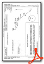
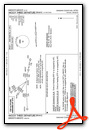
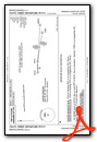
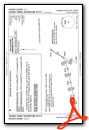
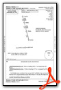
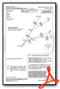
Standard Terminal Arrival (STAR) Charts
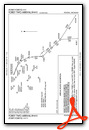
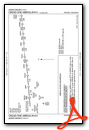
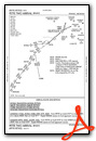

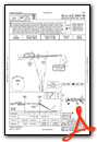
Instrument Approach Procedure (IAP) Charts


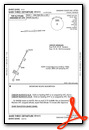
Departure Procedure (DP) Charts


Nearby Airports with Instrument Procedures
| ID | Name | Heading / Distance | ||
|---|---|---|---|---|
 |
KVLL | Oakland/Troy Airport | 124° | 13.0 |
|
Y47 | Oakland Southwest Airport | 222° | 13.3 |
|
9G2 | Prices Airport | 299° | 17.6 |
|
1D2 | Canton-Plymouth-Mettetal Airport | 184° | 19.1 |
|
D98 | Romeo State Airport | 068° | 21.2 |
|
KFNT | Bishop International Airport | 321° | 23.0 |
|
KDET | Coleman A Young Municipal Airport | 129° | 23.7 |
|
57D | Ray Community Airport | 079° | 23.9 |
|
KOZW | Livingston County/Spencer J Hardy Airport | 265° | 25.0 |
|
D95 | Dupont/Lapeer Airport | 015° | 24.9 |
|
KMTC | Selfridge Angb Airport | 096° | 26.0 |
|
KYIP | Willow Run Airport | 190° | 26.0 |
Fuel Providers

Airport Images

By: 15zenderb

By: Stanislav30


