Login
Register


52A
Madison Municipal Airport
Official FAA Data Effective 2026-02-19 0901Z
Chart Supplement

VFR Chart of 52A
Sectional Charts at SkyVector.com
IFR Chart of 52A
Enroute Charts at SkyVector.com
Location Information for 52A
Coordinates: N33°36.73' / W83°27.63'Located 02 miles NE of Madison, Georgia on 70 acres of land. View all Airports in Georgia.
Surveyed Elevation is 694 feet MSL.
Operations Data
|
|
Airport Communications
| ATLANTA APPROACH: | 132.475 ;0615-2200 291.1 ;0615-2200 |
|---|---|
| ATLANTA DEPARTURE: | 132.475 ;0615-2200 291.1 ;0615-2200 |
| CTAF: | 122.800 |
| UNICOM: | 122.800 |
| AWOS-3PT at D73 (15.5 NW): | 120.825 678-635-3668 |
| AWOS-3 at CPP (16.0 E): | 124.525 706-453-0017 |
| AWOS-3 at CVC (19.4 W): | 118.725 770-385-7057 |
- APCH/DEP SVC PRVDD BY ATLANTA TRACON 0615-2200 ON FREQS 132.475/291.1 OTHER TIMES BY ATLANTA ARTCC ON FREQS 127.5/316.05 (ATHENS RCAG).
Nearby Navigation Aids
|
| ||||||||||||||||||||||||||||||||||||||||||||||||||||||||||||


Runway 14/32
| Dimensions: | 3806 x 75 feet / 1160 x 23 meters | |
|---|---|---|
| Surface: | Asphalt in Fair Condition | |
| Weight Limits: | S-20 | |
| Edge Lighting: | Medium Intensity | |
| Runway 14 | Runway 32 | |
| Coordinates: | N33°36.97' / W83°27.86' | N33°36.48' / W83°27.39' |
| Elevation: | 636.3 | 694.0 |
| Traffic Pattern: | Left | Right |
| Runway Heading: | 141° True | 321° True |
| Displaced Threshold: | 1131 Feet | |
| Declared Distances: | TORA:3806 TODA:3806 ASDA:3740 LDA:3740 | TORA:3806 TODA:3806 ASDA:3806 LDA:2675 |
| Markings: | Non-Precision Instrument in good condition. | Non-Precision Instrument in good condition. |
| Glide Slope Indicator | P2L (3.00° Glide Path Angle) | |
| Obstacles: | 33 ft Trees 215 ft from runway, 248 ft left of center CONTROLLING OBSTRUCTION EXCEEDS A 45 DEGREE SLOPE |
15 ft Road 201 ft from runway APCH RATIO 34:1 TO DSPLCD THR, 1530 FT FM DSPLCD THR, 200 FT RIGHT. 9 FT SECURITY FENCE CROSSES APPH 175 FT FM RY END, AND 15 FT ROAD CROSSES APCH 200 FT FROM RY END. |
Services Available
| Fuel: | 100LL (blue) |
|---|---|
| Transient Storage: | Tiedowns |
| Airframe Repair: | MINOR |
| Engine Repair: | MINOR |
| Bottled Oxygen: | NONE |
| Bulk Oxygen: | NONE |
Ownership Information
| Ownership: | Publicly owned | |
|---|---|---|
| Owner: | CITY OF MADISON | |
| 132 NORTH MAIN STREET | ||
| MADISON, GA 30650 | ||
| 706-342-1251 | ||
| Manager: | JOHN KLIMM | CITY MGR |
| 132 NORTH MAIN STREET | ||
| MADISON, GA 30650 | ||
| 706-342-1251 | ARPT PHONE 706-342-9857 | |
Other Remarks
- FOR CD CTC ATLANTA APCH AT 678-364-6131, WHEN APCH CLSD CTC ATLANTA ARTCC AT 770-210-7692.
- 0LL SELF SVC FUEL AVBL 24 HRS WITH CREDIT CARD.
- ACTVT MIRL RY 14/32 & PAPI RY 14 - CTAF.
Weather Minimums

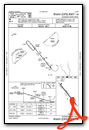
Instrument Approach Procedure (IAP) Charts

Nearby Airports with Instrument Procedures
| ID | Name | Heading / Distance | ||
|---|---|---|---|---|
 |
D73 | Cy Nunnally Memorial Airport | 311° | 15.5 |
|
KCPP | Greene County Regional Airport | 092° | 16.2 |
|
KCVC | Covington Municipal Airport | 273° | 19.4 |
|
KAHN | Athens/Ben Epps Airport | 018° | 21.2 |
|
KWDR | Barrow County Airport | 335° | 24.5 |
|
KMLJ | Baldwin County Regional Airport | 158° | 29.5 |
|
KLZU | Gwinnett County/Briscoe Field Airport | 311° | 33.3 |
|
KIIY | Washington/Wilkes County Airport | 072° | 33.8 |
|
KJCA | Jackson County Airport | 351° | 34.2 |
|
KEBA | Elbert County-Patz Field Airport | 047° | 43.2 |
|
KGVL | Lee Gilmer Memorial Airport | 335° | 43.7 |
|
KPDK | Dekalb-Peachtree Airport | 290° | 45.0 |
Airport Images
Do you have a recent image of this airport? Upload it here!


