Login
Register


PDK
Dekalb-Peachtree Airport
Official FAA Data Effective 2026-02-19 0901Z
From the Flight Deck
Chart Supplement

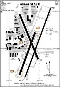
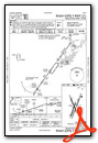
KPDK Airport Diagram
VFR Chart of KPDK
Sectional Charts at SkyVector.com
IFR Chart of KPDK
Enroute Charts at SkyVector.com
Location Information for KPDK
Coordinates: N33°52.56' / W84°18.12'Located 08 miles NE of Atlanta, Georgia on 745 acres of land. View all Airports in Georgia.
Surveyed Elevation is 998 feet MSL.
Operations Data
|
|
Airport Communications
| ATIS: | 128.4 |
|---|---|
| ASOS: | 128.4 Tel. 770-457-1691 |
| PEACHTREE TOWER: | 120.9 127.2 281.5 |
| PEACHTREE GROUND: | 121.6 |
| ATLANTA APPROACH: | 126.975 239.275 |
| ATLANTA DEPARTURE: | 126.975 239.275 |
| CLEARANCE DELIVERY: | 125.2 120.9 |
| CTAF: | 120.900 |
| BOKRT STAR: | 119.8 354.125 |
| UNICOM: | 122.950 |
| WRGNZ STAR: | 128.575 343.675 |
| ATIS at MGE (10.8 W): | 269.5 |
| ATIS at FTY (12.3 SW): | 120.175 |
| ASOS at FTY (12.4 SW): | 404-696-5660 |
Nearby Navigation Aids
|
| ||||||||||||||||||||||||||||||||||||||||||||||||||||||||||||


Runway 03R/21L
| Dimensions: | 6001 x 100 feet / 1829 x 30 meters | |
|---|---|---|
| Surface: | Concrete / Grooved in Good Condition | |
| Weight Limits: | S-46, D-75 | |
| Edge Lighting: | High Intensity | |
| Runway 03R | Runway 21L | |
| Coordinates: | N33°52.12' / W84°18.24' | N33°53.04' / W84°17.82' |
| Elevation: | 995.5 | 982.6 |
| Traffic Pattern: | Right | Left |
| Runway Heading: | 21° True | 201° True |
| Displaced Threshold: | 1005 Feet | |
| Declared Distances: | TORA:5411 TODA:6001 ASDA:5411 LDA:5411 | TORA:6001 TODA:6001 ASDA:6001 LDA:5001 |
| Markings: | Precision Instrument in poor condition. | Precision Instrument in poor condition. |
| Glide Slope Indicator | V4L (3.00° Glide Path Angle) | P2R (3.00° Glide Path Angle) |
| RVR Equipment | Rollout | Touchdown |
| Approach Lights: | MALSF 1,400 Foot Medium-intensity Approach Lighting System with sequenced flashers. | |
| REIL: | Yes | |
| Obstacles: | 1 ft Building 201 ft from runway, 452 ft right of center | 40 ft Pole 556 ft from runway, 338 ft right of center RWY 21L APCH RATIO 32:1 TO DSPLCD THLD. |
Runway 16/34
| Dimensions: | 3968 x 150 feet / 1209 x 46 meters | |
|---|---|---|
| Surface: | Asphalt in Excellent Condition | |
| Weight Limits: | S-20 | |
| Edge Lighting: | Medium Intensity | |
| Runway 16 | Runway 34 | |
| Coordinates: | N33°52.96' / W84°18.33' | N33°52.36' / W84°18.03' |
| Elevation: | 998.1 | 991.2 |
| Traffic Pattern: | Left | Left |
| Runway Heading: | 157° True | 337° True |
| Markings: | Basic in good condition. | Basic in good condition. |
| Glide Slope Indicator | V4L (3.40° Glide Path Angle) | V4L (3.30° Glide Path Angle) |
| Obstacles: | 86 ft Trees 1703 ft from runway, 95 ft left of center | 41 ft Trees 366 ft from runway, 97 ft left of center |
Runway 03L/21R
| Dimensions: | 3746 x 150 feet / 1142 x 46 meters | |
|---|---|---|
| Surface: | Asphalt in Fair Condition | |
| Weight Limits: | S-20 | |
| Edge Lighting: | Medium Intensity | |
| Runway 03L | Runway 21R | |
| Coordinates: | N33°52.14' / W84°18.34' | N33°52.72' / W84°18.08' |
| Elevation: | 990.2 | 976.6 |
| Traffic Pattern: | Left | Right |
| Runway Heading: | 21° True | 201° True |
| Markings: | Basic in good condition. | Basic in good condition. |
| Glide Slope Indicator | P2L (3.00° Glide Path Angle) | P2L (3.00° Glide Path Angle) |
| Obstacles: | 49 ft Trees 1310 ft from runway, 65 ft left of center | |
Helipad H1
| Dimensions: | 56 x 56 feet / 17 x 17 meters | |
|---|---|---|
| Surface: | Concrete in Good Condition | |
| Edge Lighting: | Perimeter | |
| Coordinates: | N33°53.05' / W84°18.37' | N0°0.00' / E0°0.00' |
| Elevation: | 998.2 | |
Services Available
| Fuel: | 100LL (blue), Jet-A, Jet A+ |
|---|---|
| Transient Storage: | Hangars,Tiedowns |
| Airframe Repair: | MAJOR |
| Engine Repair: | MAJOR |
| Bottled Oxygen: | HIGH/LOW |
| Bulk Oxygen: | HIGH/LOW |
| Other Services: | AIR AMBULANCE SERVICES,AVIONICS,CHARTER SERVICE,PILOT INSTRUCTION,AIRCRAFT RENTAL,AIRCRAFT SALES |
Ownership Information
| Ownership: | Publicly owned | |
|---|---|---|
| Owner: | DEKALB COUNTY | |
| 1300 COMMERCE DR / SUITE 600 | ||
| DECATUR, GA 30030 | ||
| 770-936-5440 | ||
| Manager: | HUNTER HINES | |
| 2000 AIRPORT RD / RM 212 | ||
| ATLANTA, GA 30341 | ||
| 770-936-5440 | ||
Other Remarks
- VOLUNTARY NIGHT CURFEW IN EFFECT FROM 2300-0600. NO HIGH POWER ENGINE/MAINTENANCE RUNUPS FROM 2200-0700.
- NOISE SENSITIVE AREAS ALL QUADRANTS. PILOTS USE CLOSE-IN DEPARTURE PROCEDURES.
- HEAVY VFR HELO OPS NW CORNER AND EASTSIDE OF ARPT. HELI LCTD NORTH OF RY 16 THLD.
- PPR FOR ALL TRANSIENT MIL ACFT.
- PPR FOR ACFT WITH MAX GROSS CERTIF WEIGHT MORE THAN 75,000 LBS.
- BE ALERT DURG ACFT GRND OPS. MULTIPLE RY/TWY CROSSINGS REQUIRED.
- BE ALERT: PILOTS SHOULD BE ALERT WHEN OPERATING AT PDK DUE TO HIGH NUMBER OF RY INCURSIONS.
- ALL TWY K AND ALL TWY L AND TWY C EAST OF TWY D ARE NON-MOVEMENT AREAS.
- ARFF ON FIELD, NO INDEX.
- 3R/21L MARKINGS FADED
- 3R/21L MARKINGS FADED
- PERIMETER LGTS H1 OPER DUSK-DAWN. REIL RWY 03R; VASI RWY 03R, 16, 34; PAPI RWY 03L, 21L, 21R; MIRL RWY 03L/21R, 16/34 - OPR DRG TWR HRS. WHEN ATCT CLSD HIRL RWY 03R/21L PRESET MED INTST; TO INCR INTST & ACTVT MALSF RWY 21L AND TWY LGTS - 120.0.
- ENGINEERED MATERIALS ARRESTING SYSTEM, 160 FT IN WIDE 600 FT IN LENGTH, LOCATED AT DEPARTURE END OF RWY 21L.
Weather Minimums


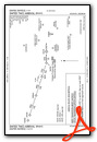
Standard Terminal Arrival (STAR) Charts


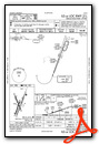
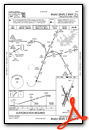
Instrument Approach Procedure (IAP) Charts


Nearby Airports with Instrument Procedures
| ID | Name | Heading / Distance | ||
|---|---|---|---|---|
 |
KMGE | Dobbins Arb Airport | 282° | 10.8 |
|
KFTY | Fulton County Exec/Charlie Brown Field Airport | 242° | 12.4 |
|
KATL | Hartsfield/Jackson Atlanta International Airport | 203° | 15.7 |
|
KRYY | Cobb County International/Mccollum Field Airport | 299° | 16.9 |
|
KLZU | Gwinnett County/Briscoe Field Airport | 070° | 18.0 |
|
KCNI | Cherokee County Regional Airport | 347° | 26.8 |
|
KCVC | Covington Municipal Airport | 122° | 27.1 |
|
KHMP | Atlanta Speedway Airport | 182° | 29.1 |
|
D73 | Cy Nunnally Memorial Airport | 100° | 31.0 |
|
KVPC | Cartersville Airport | 298° | 31.0 |
|
KPUJ | Paulding Northwest Atlanta Airport | 274° | 32.0 |
|
KWDR | Barrow County Airport | 078° | 32.3 |
Fuel Providers

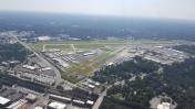
Airport Images
By: posi211

By: SPAflyer


