Login
Register


57S
Troy Airport
Official FAA Data Effective 2026-02-19 0901Z
Chart Supplement

VFR Chart of 57S
Sectional Charts at SkyVector.com
IFR Chart of 57S
Enroute Charts at SkyVector.com
Location Information for 57S
Coordinates: N48°28.81' / W115°54.21'Located 01 miles NW of Troy, Montana on 40 acres of land. View all Airports in Montana.
Surveyed Elevation is 2017 feet MSL.
Operations Data
|
|
Airport Communications
| CTAF: | 122.900 |
|---|---|
| AWOS-A at S59 (20.3 SE): | 118.575 406-293-4631 |
| AWOS-3PT at 65S (21.3 NW): | 132.575 208-267-3995 |
| AWOS-2 at SZT (28.3 W): | 135.425 208-263-3074 |
Nearby Navigation Aids
|
| ||||||||||||||||||||||||||||||||||||||||||||||||||||||


Runway 14/32
| Dimensions: | 3570 x 30 feet / 1088 x 9 meters | |
|---|---|---|
| Surface: | Asphalt in Poor Condition CRACKS, WEEDS, BROKEN ASPH. | |
| Runway 14 | Runway 32 | |
| Traffic Pattern: | Left | Right |
| Displaced Threshold: | 825 Feet | 780 Feet |
| Markings: | Non-Standard in fair condition. | Non-Standard in fair condition. |
| Obstacles: | 80 ft Trees 200 ft from runway CTLG OBSTN EXCEEDS A 45 DEG SLP. APCH SLP 16:1 FM DTHR. +5-80 FT TREES WI PRI SFC BGN 25-200 FT FT FM RWY END BOTH SIDES. |
69 ft Trees 445 ft from runway APCH SLP 13:1 FM DTHR. +5 FT FENCE 13 FT FM RWY END BOTH SIDES. |
Services Available
| Fuel: | NONE |
|---|---|
| Transient Storage: | Tiedowns |
| Airframe Repair: | NOT AVAILABLE |
| Engine Repair: | NOT AVAILABLE |
| Bottled Oxygen: | NOT AVAILABLE |
| Bulk Oxygen: | NOT AVAILABLE |
Ownership Information
| Ownership: | Publicly owned | |
|---|---|---|
| Owner: | USFS | LINCOLN COUNTY. |
| 1437 N HIGHWAY 2 | ||
| TROY, MT 59935 | ||
| 406-295-4693 | WINTER - 406-295-4693. | |
| Manager: | GLENN WHITFIELD | |
| 117 SNOWSHOE LANE | ||
| TROY, MT 59935 | ||
| 406-334-7038 | ||
Other Remarks
- LGTD HELI ADJ TO SEGMENTED CIRCLE.
- NO SNOW REMOVAL. ARPT SFC COND UNMON.
- PEDESTRIAN WALKING TRAIL INVOF MOV AREA.
- FOR CD CTC SEATTLE ARTCC AT 253-351-3694.
- DTHR MKD WITH WHITE ARROWS.
- DTHR MKD WITH WHITE ARROWS.
Nearby Airports with Instrument Procedures
| ID | Name | Heading / Distance | ||
|---|---|---|---|---|
 |
S59 | Libby Airport | 125° | 20.3 |
|
65S | Boundary County Airport | 313° | 21.5 |
|
KSZT | Sandpoint Airport | 247° | 28.4 |
|
KCOE | Coeur D'Alene/Pappy Boyington Field Airport | 221° | 56.1 |
|
KGPI | Glacier Park International Airport | 098° | 66.7 |
|
KDEW | Deer Park Airport | 243° | 68.5 |
|
KSFF | Felts Field Airport | 230° | 74.5 |
|
KGEG | Spokane International Airport | 232° | 83.6 |
|
8S1 | Polson Airport | 123° | 83.6 |
|
KSKA | Fairchild AFB Airport | 234° | 87.6 |
|
7S0 | Ronan Airport | 126° | 91.0 |
|
CZPC | Pincher Creek Airport | 049° | 97.8 |
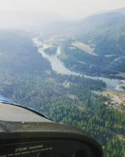
Airport Images

By: dporter22
By: AnselAV


