Login
Register


5W4
P K Airpark Airport
Official FAA Data Effective 2026-01-22 0901Z
Chart Supplement

VFR Chart of 5W4
Sectional Charts at SkyVector.com
IFR Chart of 5W4
Enroute Charts at SkyVector.com
Location Information for 5W4
Coordinates: N35°1.19' / W79°11.46'Located 03 miles NE of Raeford, North Carolina on 51 acres of land. View all Airports in North Carolina.
Surveyed Elevation is 304 feet MSL.
Operations Data
|
|
Airport Communications
| FAYETTEVILLE APPROACH: | 127.8 290.25 |
|---|---|
| FAYETTEVILLE DEPARTURE: | 127.8 290.25 |
| CTAF: | 123.000 |
| UNICOM: | 123.000 |
| D-ATIS at POB (12.5 NE): | 132.3 |
| ATIS at FBG (14.3 NE): | 139.25 |
| D-ATIS at HFF (15.1 W): | 141.4 |
Nearby Navigation Aids
|
| ||||||||||||||||||||||||||||||||||||||||||||||||||||||||||||


Runway 04/22
| Dimensions: | 3402 x 60 feet / 1037 x 18 meters | |
|---|---|---|
| Surface: | Asphalt in Excellent Condition | |
| Weight Limits: | S-30 | |
| Edge Lighting: | Medium Intensity | |
| Runway 04 | Runway 22 | |
| Coordinates: | N35°0.96' / W79°11.65' | N35°1.43' / W79°11.27' |
| Elevation: | 292.0 | 304.0 |
| Traffic Pattern: | Left | Right |
| Runway Heading: | 33° True | 213° True |
| Markings: | Non-Precision Instrument in good condition. | Non-Precision Instrument in good condition. |
| Obstacles: | 56 ft Trees 589 ft from runway, 84 ft right of center | 39 ft Trees 615 ft from runway, 32 ft left of center 20 FT BRUSH 0-200 FT FM THR 121 FT RIGHT OF CNTRLN. |
Services Available
| Fuel: | 100LL (blue), Jet A+ |
|---|---|
| Transient Storage: | Tiedowns |
| Airframe Repair: | NONE |
| Engine Repair: | NONE |
| Bottled Oxygen: | NONE |
| Bulk Oxygen: | NONE |
| Other Services: | PARACHUTE JUMP ACTIVITY,ANNUAL SURVEYING |
Ownership Information
| Ownership: | Privately Owned | |
|---|---|---|
| Owner: | BILLIE THACKER | |
| PO DRAWER 1510 | ||
| RAEFORD, NC 28376 | ||
| 910-875-3261 | ||
| Manager: | JOEY D'ANNUNZIO | |
| 155 AIRPORT DRIVE | ||
| RAEFORD, NC 28376 | ||
| (910) 904-0000 | ||
Other Remarks
- THIS AIRPORT HAS BEEN SURVEYED BY THE NATIONAL GEODETIC SURVEY.
- CTN: LOW FLYING MIL ACFT OPS IN VCNTY; ARPT LCTD WI FT. LIBERTY SOUTH B MOA.
- FQT PAJA TO TARGET 300 FT SE OF TRML APN.
- ACFT IN VCNTY MNT 123.5.
- FLY ONE MILE DOWNWIND LEG TO PREVENT CONFLICTS WITH PAJA (DROP ZONE SOUTHEAST FM RWY).
- AFT HRS SVC 910-578-4401.
- MNT FREQ 123.5 FOR PAJA.
- FOR CD CTC WASHINGTON ARTCC AT 703-771-3587.
- CTN DO NOT OVERFLY AIRPORT DUE TO PAJA.
Weather Minimums

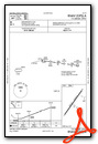
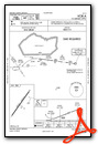
Instrument Approach Procedure (IAP) Charts
Nearby Airports with Instrument Procedures
| ID | Name | Heading / Distance | ||
|---|---|---|---|---|
 |
KPOB | Pope AAF Airport | 043° | 12.5 |
|
KFAY | Fayetteville Regional/Grannis Field Airport | 096° | 15.4 |
|
KMEB | Laurinburg/Maxton Airport | 212° | 16.1 |
|
KSOP | Moore County Airport | 323° | 16.3 |
|
KLBT | Lumberton Regional Airport | 165° | 25.4 |
|
KRCZ | Richmond County Airport | 254° | 29.1 |
|
KHRJ | Harnett Regional Jetport Airport | 046° | 31.2 |
|
KTTA | Raleigh Exec Jetport At Sanford-Lee County Airport | 007° | 34.0 |
|
KDLC | Dillon County Airport | 194° | 35.3 |
|
KBBP | Marlboro County Jetport/H E Avent Field Airport | 228° | 35.9 |
|
43A | Montgomery County Airport | 306° | 36.7 |
|
KEYF | Curtis L Brown Jr Field Airport | 129° | 39.2 |
Airport Images
Do you have a recent image of this airport? Upload it here!


