Login
Register


65MS
Maverick Hill Airport
Official FAA Data Effective 2026-01-22 0901Z
VFR Chart of 65MS
Sectional Charts at SkyVector.com
IFR Chart of 65MS
Enroute Charts at SkyVector.com
Location Information for 65MS
Coordinates: N34°33.88' / W89°53.04'Located 05 miles SE of Senatobia, Mississippi on 3 acres of land. View all Airports in Mississippi.
Estimated Elevation is 340 feet MSL.
Operations Data
|
|
Airport Communications
| AWOS-3PT at PMU (12.2 S): | 118.225 662-563-6267 |
|---|---|
| AWOS-3PT at UOX (20.3 SE): | 132.725 662-234-9751 |
| AWOS-3 at UTA (24.0 W): | 118.075 662-363-1652 |
Nearby Navigation Aids
|
| ||||||||||||||||||||||||||||||||||||||||||||||||||||||


Runway 18/36
| Dimensions: | 1700 x 60 feet / 518 x 18 meters | |
|---|---|---|
| Surface: | Turf in Fair Condition | |
| Runway 18 | Runway 36 | |
| Coordinates: | N34°34.02' / W89°53.04' | N34°33.74' / W89°53.04' |
| Elevation: | 340.0 | 309.0 |
| Runway Heading: | 180° True | 360° True |
Ownership Information
| Ownership: | Privately Owned | |
|---|---|---|
| Owner: | MITCH MATHENY | |
| 656 SUGARBUSH CV S | ||
| COLLIERVILLE, TN 38017 | ||
| 901-210-7005 | ||
| Manager: | MITCH MATHENY | |
| 656 SUGARBUSH CV S | ||
| COLLIERVILLE, TN 38017 | ||
| 901-210-7005 | MITCH@DANAMATHENY.ORG. | |
Other Remarks
- OWNER DESIRES ARPT BE CHARTED.
Nearby Airports with Instrument Procedures
| ID | Name | Heading / Distance | ||
|---|---|---|---|---|
 |
KPMU | Panola County Airport | 182° | 12.1 |
|
KUOX | University-Oxford Airport | 121° | 20.3 |
|
M41 | Holly Springs-Marshall County Airport | 051° | 23.0 |
|
KUTA | Tunica Municipal Airport | 287° | 24.1 |
|
KOLV | Olive Branch/Taylor Field Airport | 010° | 25.3 |
|
KMMS | Selfs Airport | 225° | 28.4 |
|
KMEM | Frederick W Smith International Airport | 350° | 29.0 |
|
KCKM | Fletcher Field Airport | 243° | 35.0 |
|
KAWM | West Memphis Municipal Airport | 333° | 38.3 |
|
M01 | General Dewitt Spain Airport | 347° | 39.0 |
|
KHEE | Thompson-Robbins Airport | 271° | 39.2 |
|
M72 | New Albany/Union County Airport | 091° | 42.6 |
Airport Images
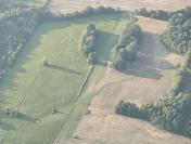
By: Big Orange Bird


