Login
Register


67AR
Wedington Woods Airport
Official FAA Data Effective 2026-01-22 0901Z
VFR Chart of 67AR
Sectional Charts at SkyVector.com
IFR Chart of 67AR
Enroute Charts at SkyVector.com
Location Information for 67AR
Coordinates: N36°5.87' / W94°18.45'Located 07 miles W of Fayetteville, Arkansas. View all Airports in Arkansas.
Estimated Elevation is 1090 feet MSL.
Operations Data
|
|
Airport Communications
| CTAF: | 122.900 |
|---|---|
| ATIS at FYV (8.7 SE): | 119.575 |
| ASOS at FYV (8.7 SE): | 119.575 479-442-5237 |
| AWOS-3 at ASG (10.3 NE): | 124.675 479-750-2967 |
Nearby Navigation Aids
|
| ||||||||||||||||||||||||||||||||||||||||||||||||||||||||||||


Runway 17/35
| Dimensions: | 3100 x 50 feet / 945 x 15 meters | |
|---|---|---|
| Surface: | Turf | |
| Runway 17 | Runway 35 | |
| Traffic Pattern: | Left | Left |
| Obstacles: | ft Hill ft from runway | |
Services Available
| Fuel: | NONE |
|---|---|
| Transient Storage: | NONE |
| Airframe Repair: | NONE |
| Engine Repair: | NONE |
| Bottled Oxygen: | NOT AVAILABLE |
| Bulk Oxygen: | NOT AVAILABLE |
Ownership Information
| Ownership: | Privately Owned | |
|---|---|---|
| Owner: | STUART DOUGHTY | AND OTHER PROPERTY OWNERS. |
| 15939 WINDSOCK LANE | ||
| FAYETTEVILLE, AR 72704 | ||
| 479-755-2604 | ||
| Manager: | STUART DOUGHTY | |
| 15939 WINDSOCK LANE | ||
| FAYETTEVILLE, AR 72704 | ||
| 479-755-2604 | ||
Other Remarks
- FOR CD CTC RAZORBACK APCH 479-649-2416, WHEN APCH CLSD CTC MEMPHIS ARTCC AT 901-368-8453/8449.
- CTAF: 122.9
- DUE TO SURROUNDING TRRN, RECOMMEND LNDG ON RY 17 AND TAKING OFF ON RY 35
- ARPT SITS IN A N/S VALLEY. IT IS DIFFICULT TO SEE WHEN APPROACHING FROM THE E OR W.
- RY 17 - 1.5% GRADE UP, RY 35 - 1.5% GRADE DOWN
Nearby Airports with Instrument Procedures
| ID | Name | Heading / Distance | ||
|---|---|---|---|---|
 |
KFYV | Drake Field Airport | 129° | 8.7 |
|
KASG | Springdale Municipal Airport | 062° | 10.3 |
|
KSLG | Smith Field Airport | 302° | 10.5 |
|
KXNA | Northwest Arkansas Ntl Airport | 359° | 11.0 |
|
KVBT | Bentonville Municipal/Louise M Thaden Field Airport | 016° | 15.4 |
|
5M5 | Crystal Lake Airport | 335° | 16.2 |
|
KROG | Rogers Exec - Carter Field Airport | 030° | 19.1 |
|
H34 | Huntsville Municipal Airport | 092° | 26.9 |
|
KTQH | Tahlequah Municipal Airport | 253° | 35.4 |
|
KGMJ | Grove Regional Airport | 325° | 37.0 |
|
4M1 | Carroll County Airport | 062° | 37.2 |
|
94K | Cassville Municipal Airport | 028° | 41.0 |
Airport Images
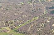
By: japanjeff


