Login
Register


XNA
Northwest Arkansas Ntl Airport
Official FAA Data Effective 2025-11-27 0901Z
Chart Supplement

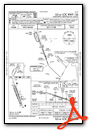
KXNA Airport Diagram

VFR Chart of KXNA
Sectional Charts at SkyVector.com
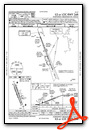
IFR Chart of KXNA
Enroute Charts at SkyVector.com
Location Information for KXNA
Coordinates: N36°16.89' / W94°18.47'Located 15 miles NW of Fayetteville/Springdale/Rogers, Arkansas on 2680 acres of land. View all Airports in Arkansas.
Surveyed Elevation is 1288 feet MSL.
Operations Data
|
|
Airport Communications
| ATIS: | 119.425 |
|---|---|
| ASOS: | 119.425 Tel. 479-203-0109 |
| NORTHWEST ARKANSAS NTL TOWER: | 127.1 |
| NORTHWEST ARKANSAS NTL GROUND: | 121.9 |
| RAZORBACK APPROACH: | 121.0 ;WEST 126.6 ;EAST 244.575 ;WEST 305.2 ;EAST |
| RAZORBACK DEPARTURE: | 121.0 ;WEST 126.6 ;EAST 244.575 ;WEST 305.2 ;EAST |
| IC: | 121.0 ;WEST 244.575 ;WEST |
| CTAF: | 127.100 |
| CLASS C: | 121.0 ;WEST 126.6 ;EAST 244.575 ;WEST 305.2 ;EAST |
| HIGHFILL DP: | 121.0 ;WEST 126.6 ;EAST 244.575 ;WEST 305.2 ;EAST |
| AWOS-3PT at VBT (5.8 NE): | 134.975 479-273-9198 |
| AWOS-3PT at SLG (10.3 SW): | 118.375 479-524-9893 |
| AWOS-3 at ASG (11.1 SE): | 124.675 479-750-2967 |
- APCH/DEP SVC PRVDD BY MEMPHIS ARTCC ON FREQS 126.1/269.0 (FAYETTEVILLE RCAG) WHEN RAZORBACK APCH CTL CLSD.
- COMMUNICATIONS PRVDD BY JONESBORO RADIO ON FREQ 122.4 (HIGHFILL RCO).
Nearby Navigation Aids
|
| ||||||||||||||||||||||||||||||||||||||||||||||||||||||||||||


Runway 16L/34R
| Dimensions: | 8801 x 150 feet / 2683 x 46 meters | |
|---|---|---|
| Surface: | Concrete / Grooved in Good Condition | |
| Weight Limits: | S-120, D-223, ST-377, DT-864
PCR VALUE: 765/R/C/W/T
| |
| Edge Lighting: | High Intensity | |
| Runway 16L | Runway 34R | |
| Coordinates: | N36°17.59' / W94°18.72' | N36°16.23' / W94°18.10' |
| Elevation: | 1287.0 | 1264.6 |
| Runway Heading: | 160° True | 340° True |
| Declared Distances: | TORA:8800 TODA:8800 ASDA:8800 LDA:8800 | TORA:8800 TODA:8800 ASDA:8800 LDA:8800 |
| Markings: | Precision Instrument in good condition. | Precision Instrument in good condition. |
| Glide Slope Indicator | P4L (3.00° Glide Path Angle) | P4L (3.00° Glide Path Angle) |
| RVR Equipment | Touchdown Rollout | Touchdown Rollout |
| Approach Lights: | MALSR 1,400 Foot Medium-intensity Approach Lighting System with runway alignment indicator lights. | MALSR 1,400 Foot Medium-intensity Approach Lighting System with runway alignment indicator lights. |
Runway 16R/34L
| Dimensions: | 8800 x 150 feet / 2682 x 46 meters | |
|---|---|---|
| Surface: | Concrete / Grooved in Good Condition | |
| Weight Limits: | S-120, D-233, ST-377, DT-864
PCR VALUE: 765/R/C/W/T
| |
| Edge Lighting: | Medium Intensity | |
| Runway 16R | Runway 34L | |
| Coordinates: | N36°17.56' / W94°18.83' | N36°16.20' / W94°18.21' |
| Elevation: | 1288.2 | 1265.3 |
| Runway Heading: | 160° True | 340° True |
| Declared Distances: | TORA:8800 TODA:8800 ASDA:8800 LDA:8800 | TORA:8800 TODA:8800 ASDA:8800 LDA:8800 |
| Markings: | Precision Instrument in good condition. | Precision Instrument in good condition. |
Services Available
| Fuel: | 100LL (blue), Jet-A |
|---|---|
| Transient Storage: | Hangars,Tiedowns |
| Airframe Repair: | NOT AVAILABLE |
| Engine Repair: | NOT AVAILABLE |
| Bottled Oxygen: | NOT AVAILABLE |
| Bulk Oxygen: | LOW |
| Other Services: | AIR FREIGHT SERVICES,CHARTER SERVICE |
Ownership Information
| Ownership: | Publicly owned | |
|---|---|---|
| Owner: | NW ARKANSAS RGNL ARPT AUTH. | |
| 1 AIRPORT BLVD, SUITE 100 | ||
| BENTONVILLE, AR 72713 | ||
| 479-205-1000 | ||
| Manager: | ANDREW BRANCH | |
| 1 AIRPORT BLVD, SUITE 100 | ||
| BENTONVILLE, AR 72713 | ||
| 479-205-1000 | ||
Other Remarks
- BIRD ACTIVITY ON & INVOF ARPT.
- CTN ELEVATED RWY THLD LGTS AER RWYS 16L & 34R.
- FOR CD CTC MEMPHIS ARTCC AT 901-368-8453/8449.
- DSTC & DIRECTION TO ARPT FM SPRINGDALE IS 10 NM NW & FM ROGERS MSA IS 9 NM SW.
- 0LL FOR FUEL SERVICES USE FREQ 130.05.
- WHEN ATCT CLSD ACTVT MALSR RWY 16L&34R; HIRL RWY 16L/34R - CTAF. PAPI RWY 16L & 34R OPER CONSLY.
Weather Minimums


Instrument Approach Procedure (IAP) Charts

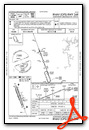
Departure Procedure (DP) Charts

Nearby Airports with Instrument Procedures
| ID | Name | Heading / Distance | ||
|---|---|---|---|---|
 |
KVBT | Bentonville Municipal/Louise M Thaden Field Airport | 048° | 5.7 |
|
5M5 | Crystal Lake Airport | 299° | 7.6 |
|
KSLG | Smith Field Airport | 238° | 10.4 |
|
KASG | Springdale Municipal Airport | 124° | 11.1 |
|
KROG | Rogers Exec - Carter Field Airport | 060° | 11.2 |
|
KFYV | Drake Field Airport | 157° | 17.9 |
|
KGMJ | Grove Regional Airport | 313° | 28.5 |
|
H34 | Huntsville Municipal Airport | 114° | 29.5 |
|
94K | Cassville Municipal Airport | 038° | 31.8 |
|
KEOS | Neosho Hugh Robinson Airport | 352° | 32.0 |
|
4M1 | Carroll County Airport | 079° | 33.7 |
|
1K8 | South Grand Lake Regional Airport | 295° | 37.7 |
Fuel Providers

Airport Images

By: japanjeff


