Login
Register


H34
Huntsville Municipal Airport
Official FAA Data Effective 2026-01-22 0901Z
Chart Supplement

VFR Chart of H34
Sectional Charts at SkyVector.com
IFR Chart of H34
Enroute Charts at SkyVector.com
Location Information for H34
Coordinates: N36°4.69' / W93°45.29'Located 02 miles SW of Huntsville, Arkansas on 74 acres of land. View all Airports in Arkansas.
Surveyed Elevation is 1747 feet MSL.
Operations Data
|
|
Airport Communications
| RAZORBACK APPROACH: | 126.6 305.2 |
|---|---|
| RAZORBACK DEPARTURE: | 126.6 305.2 |
| UNICOM: | 122.800 |
| CTAF: | 122.800 |
| AWOS-3 at ASG (18.6 W): | 124.675 479-750-2967 |
| ASOS at FYV (20.6 W): | 119.575 479-442-5237 |
| ATIS at FYV (20.6 W): | 119.575 |
- APCH/DEP SVC PRVDD BY MEMPHIS ARTCC ON FREQS 126.1/269.0 (FAYETTEVILLE RCAG) WHEN RAZORBACK APCH CTL CLSD.
Nearby Navigation Aids
|
| ||||||||||||||||||||||||||||||||||||||||||||||||


Runway 12/30
| Dimensions: | 3601 x 60 feet / 1098 x 18 meters | |
|---|---|---|
| Surface: | Asphalt in Fair Condition | |
| Weight Limits: | S-12 | |
| Edge Lighting: | Medium Intensity | |
| Runway 12 | Runway 30 | |
| Coordinates: | N36°4.85' / W93°45.60' | N36°4.51' / W93°45.00' |
| Elevation: | 1743.6 | 1744.9 |
| Runway Heading: | 125° True | 305° True |
| Markings: | Non-Precision Instrument in good condition. | Non-Precision Instrument in poor condition. |
Runway 03/21
| Dimensions: | 1250 x 60 feet / 381 x 18 meters | |
|---|---|---|
| Surface: | Turf in Fair Condition STEEP DROP OFF AT RY ENDS. | |
| Runway 03 | Runway 21 | |
| Coordinates: | N36°4.64' / W93°45.31' | N36°4.80' / W93°45.16' |
| Elevation: | 1739.0 | 1738.0 |
| Runway Heading: | 38° True | 218° True |
| Markings: | Non-Standard in fair condition. | Non-Standard in fair condition. |
Services Available
| Fuel: | 100LL (blue) |
|---|---|
| Transient Storage: | Tiedowns |
| Airframe Repair: | NOT AVAILABLE |
| Engine Repair: | NOT AVAILABLE |
| Bottled Oxygen: | NOT AVAILABLE |
| Bulk Oxygen: | NOT AVAILABLE |
| Other Services: | PILOT INSTRUCTION |
Ownership Information
| Ownership: | Publicly owned | |
|---|---|---|
| Owner: | CITY OF HUNTSVILLE | |
| PO BOX 844 | ||
| HUNTSVILLE, AR 72740 | ||
| 479-738-6607 | ||
| Manager: | CHARLES COGER | |
| PO BOX 844 | ||
| HUNTSVILLE, AR 72740 | ||
| 479-738-7287 | ||
Other Remarks
- ULTRALIGHT ACTIVITY ON & INVOF ARPT.
- FOR CD CTC RAZORBACK APCH 479-649-2416, WHEN APCH CLSD CTC MEMPHIS ARTCC AT 901-368-8453/8449.
- 0LL SELF SERVICE FUEL AVBL 24 HRS WITH CREDIT CARD.
- ACTVT MIRL RY 12/30 - CTAF.
Weather Minimums

Instrument Approach Procedure (IAP) Charts
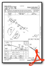
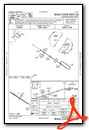
Nearby Airports with Instrument Procedures
| ID | Name | Heading / Distance | ||
|---|---|---|---|---|
 |
KASG | Springdale Municipal Airport | 288° | 18.7 |
|
4M1 | Carroll County Airport | 019° | 19.2 |
|
KFYV | Drake Field Airport | 257° | 20.7 |
|
KROG | Rogers Exec - Carter Field Airport | 315° | 24.6 |
|
KVBT | Bentonville Municipal/Louise M Thaden Field Airport | 305° | 27.6 |
|
KXNA | Northwest Arkansas Ntl Airport | 294° | 29.5 |
|
KHRO | Boone County Airport | 069° | 31.1 |
|
7M5 | Ozark/Franklin County Airport | 186° | 34.3 |
|
KSLG | Smith Field Airport | 281° | 36.4 |
|
5M5 | Crystal Lake Airport | 295° | 37.1 |
|
94K | Cassville Municipal Airport | 349° | 37.8 |
|
KBBG | Branson Airport | 044° | 38.2 |
Airport Images
Do you have a recent image of this airport? Upload it here!


