Login
Register


ASG
Springdale Municipal Airport
Official FAA Data Effective 2026-01-22 0901Z
Chart Supplement

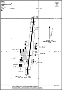
KASG Airport Diagram
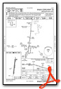
VFR Chart of KASG
Sectional Charts at SkyVector.com
IFR Chart of KASG
Enroute Charts at SkyVector.com
Location Information for KASG
Coordinates: N36°10.58' / W94°7.15'Located 01 miles SE of Springdale, Arkansas on 228 acres of land. View all Airports in Arkansas.
Surveyed Elevation is 1352 feet MSL.
Operations Data
|
|
Airport Communications
| AWOS-3: | 124.675 Tel. 479-750-2967 |
|---|---|
| SPRINGDALE TOWER: | 118.2 |
| SPRINGDALE GROUND: | 121.6 |
| RAZORBACK APPROACH: | 126.6 305.2 |
| RAZORBACK DEPARTURE: | 126.6 305.2 |
| UNICOM: | 122.950 |
| CTAF: | 118.200 |
| ATIS at FYV (10.6 S): | 119.575 |
| ASOS at FYV (10.6 S): | 119.575 479-442-5237 |
| ASOS at XNA (11.1 NW): | 119.425 479-203-0109 |
- APCH/DEP SVC PRVDD BY MEMPHIS ARTCC ON FREQS 126.1/269.0 (FAYETTEVILLE RCAG) WHEN RAZORBACK APCH CTL CLSD.
Nearby Navigation Aids
|
| ||||||||||||||||||||||||||||||||||||||||||||||||||||||||||||


Runway 18/36
| Dimensions: | 5302 x 76 feet / 1616 x 23 meters | |
|---|---|---|
| Surface: | Asphalt in Excellent Condition | |
| Weight Limits: | S-35, D-50, ST-90 | |
| Edge Lighting: | High Intensity | |
| Runway 18 | Runway 36 | |
| Coordinates: | N36°11.02' / W94°7.09' | N36°10.15' / W94°7.22' |
| Elevation: | 1339.2 | 1352.4 |
| Traffic Pattern: | Left | Left |
| Runway Heading: | 187° True | 7° True |
| Displaced Threshold: | 363 Feet | |
| Declared Distances: | TORA:5302 TODA:5302 ASDA:5302 LDA:4939 | TORA:5302 TODA:5302 ASDA:5302 LDA:5302 |
| Markings: | Precision Instrument in good condition. | Precision Instrument in good condition. |
| Glide Slope Indicator | P4L (3.00° Glide Path Angle) | P4R (3.00° Glide Path Angle) |
| Approach Lights: | MALSF 1,400 Foot Medium-intensity Approach Lighting System with sequenced flashers. | |
| REIL: | Yes | Yes |
| Obstacles: | APCH RATIO 50:1 FM DSPLCD THR. |
40 ft Trees 1750 ft from runway, 400 ft left of center |
Services Available
| Fuel: | 100LL (blue), Jet-A |
|---|---|
| Transient Storage: | Hangars,Tiedowns |
| Airframe Repair: | MAJOR |
| Engine Repair: | MAJOR |
| Bottled Oxygen: | LOW |
| Bulk Oxygen: | NONE |
| Other Services: | AIR FREIGHT SERVICES,AIR AMBULANCE SERVICES,AVIONICS,CHARTER SERVICE,PILOT INSTRUCTION,AIRCRAFT RENTAL,AIRCRAFT SALES |
Ownership Information
| Ownership: | Publicly owned | |
|---|---|---|
| Owner: | CITY OF SPRINGDALE | |
| CITY HALL, 201 SPRING ST | ||
| SPRINGDALE, AR 72764 | ||
| 479-750-8114 | ||
| Manager: | AUSTIN BERSI | |
| 802 AIRPORT AVENUE | ||
| SPRINGDALE, AR 72764 | ||
| 479-966-2010 | ||
Other Remarks
- FOR CD WHEN UNA VIA FREQ CTC RAZORBACK APCH 479-649-2416, WHEN APCH CLSD CTC MEMPHIS ARTCC AT 901-368-8453/8449.
- ALL ACFT LEFT OVERNIGHT WILL BE CHARGED A RAMP FEE UNLESS FUEL HAS BEEN PURCHASED.
- 0LL 100LL AVBL 24 HRS SELF SERVE WITH CREDIT CARD.
- ACTVT HIRL RWY 18/36 - CTAF. WHEN ATCT CLSD ACTVT MALSF RWY 18 - CTAF. ACTVT REIL RWY 18 AND 36 - 122.8.
Weather Minimums

Instrument Approach Procedure (IAP) Charts
Departure Procedure (DP) Charts

Nearby Airports with Instrument Procedures
| ID | Name | Heading / Distance | ||
|---|---|---|---|---|
 |
KFYV | Drake Field Airport | 193° | 10.6 |
|
KXNA | Northwest Arkansas Ntl Airport | 304° | 11.1 |
|
KVBT | Bentonville Municipal/Louise M Thaden Field Airport | 334° | 11.2 |
|
KROG | Rogers Exec - Carter Field Airport | 002° | 11.8 |
|
KSLG | Smith Field Airport | 273° | 18.0 |
|
H34 | Huntsville Municipal Airport | 108° | 18.7 |
|
5M5 | Crystal Lake Airport | 302° | 18.7 |
|
4M1 | Carroll County Airport | 062° | 27.0 |
|
94K | Cassville Municipal Airport | 018° | 33.0 |
|
KGMJ | Grove Regional Airport | 310° | 39.6 |
|
KEOS | Neosho Hugh Robinson Airport | 340° | 40.2 |
|
7M5 | Ozark/Franklin County Airport | 161° | 42.2 |
Airport Images
Do you have a recent image of this airport? Upload it here!


