Login
Register
69N
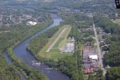
Slatington Airport
Official FAA Data Effective 2026-01-22 0901Z
VFR Chart of 69N
Sectional Charts at SkyVector.com
IFR Chart of 69N
Enroute Charts at SkyVector.com
Location Information for 69N
Coordinates: N40°45.82' / W75°36.29'Located 01 miles N of Slatington, Pennsylvania on 55 acres of land. View all Airports in Pennsylvania.
Estimated Elevation is 380 feet MSL.
Operations Data
|
|
Airport Communications
| CTAF: | 122.800 |
|---|---|
| UNICOM: | 122.800 |
| AWOS-3PT at 22N (7.8 W): | 119.350 570-386-3423 |
| ASOS at ABE (10.0 SE): | 126.975 610-477-0813 |
| ATIS at ABE (10.0 SE): | 126.975 |
Nearby Navigation Aids
|
| ||||||||||||||||||||||||||||||||||||||||||||||||||||||||||||
Runway 01/19
| Dimensions: | 2455 x 50 feet / 748 x 15 meters | |
|---|---|---|
| Surface: | Asphalt in Good Condition | |
| Edge Lighting: | Non-Standard NON STANDARD LIRL LOCATED 10 FT OUTBOARD FM RWY EDGES. RWY 19 END LGTS LOCATED OUTBOARD FROM RWY EDGES. | |
| Runway 01 | Runway 19 | |
| Coordinates: | N40°45.61' / W75°36.29' | N40°46.02' / W75°36.29' |
| Traffic Pattern: | Left | Left |
| Runway Heading: | 1° True | 181° True |
| Displaced Threshold: | 352 Feet | |
| Markings: | Non-Precision Instrument in good condition. | Basic in good condition. |
| Obstacles: | 43 ft Trees 546 ft from runway, 96 ft left of center APCH SLP 15:1 TO DTHR. |
63 ft Trees 815 ft from runway, 158 ft left of center |
Services Available
| Fuel: | 100LL (blue) |
|---|---|
| Transient Storage: | Tiedowns |
| Airframe Repair: | MAJOR |
| Engine Repair: | MAJOR |
| Bottled Oxygen: | NONE |
| Bulk Oxygen: | NONE |
| Other Services: | PILOT INSTRUCTION,AIRCRAFT RENTAL |
Ownership Information
| Ownership: | Privately Owned | |
|---|---|---|
| Owner: | ROGER P. SELL, INC | |
| 3302 FAIRLAND DR. | ||
| SCHNECKSVILLE, PA 18078 | ||
| 610-799-3302 | ||
| Manager: | ROGER S. SELL | |
| 1000 AIRPORT LANE | ||
| SLATINGTON, PA 18080 | ||
| 610-767-5881 | ||
Other Remarks
- +977 FT HILL 7700 FT FROM RWY 19 THLD.
- FOR CD CTC ALLENTOWN APCH AT 800-728-6322.
- FOR SVC AFTR HRS CALL 610-799-3302.
- RWY 01/19 CLSD TO TSNT ACFT SS-SR.
- ACTVT LIRL RWY 01/19 - CTAF.
- ACTVT ROTG BCN - CTAF.
Nearby Airports with Instrument Procedures
| ID | Name | Heading / Distance | ||
|---|---|---|---|---|
 |
22N | Jake Arner Memorial Airport | 291° | 7.7 |
 |
KABE | Lehigh Valley International Airport | 131° | 10.0 |
 |
KXLL | Allentown Queen City Municipal Airport | 155° | 12.8 |
 |
N43 | Braden Airpark Airport | 094° | 16.6 |
 |
KUKT | Quakertown Airport | 152° | 22.2 |
 |
KHZL | Hazleton Regional Airport | 307° | 22.2 |
 |
KMPO | Pocono Mountains Regional Airport | 024° | 24.7 |
 |
KCKZ | Pennridge Airport | 147° | 26.7 |
 |
KRDG | Reading Regional/Carl A Spaatz Field Airport | 215° | 28.4 |
 |
N85 | Alexandria Airport | 111° | 28.7 |
 |
1N7 | Blairstown Airport | 065° | 30.3 |
 |
N47 | Pottstown Municipal Airport | 185° | 30.3 |


