Login
Register


N43
Braden Airpark Airport
Official FAA Data Effective 2025-11-27 0901Z
Chart Supplement

VFR Chart of N43
Sectional Charts at SkyVector.com
IFR Chart of N43
Enroute Charts at SkyVector.com
Location Information for N43
Coordinates: N40°44.53' / W75°14.58'Located 03 miles N of Easton, Pennsylvania on 80 acres of land. View all Airports in Pennsylvania.
Surveyed Elevation is 396 feet MSL.
Operations Data
|
|
Airport Communications
| ALLENTOWN APPROACH: | 119.65 ;3000 FT & BLW 124.45 ;ABV 3000 FT 351.8 |
|---|---|
| ALLENTOWN DEPARTURE: | 119.65 ;3000 FT & BLW 124.45 ;ABV 3000 FT 351.8 |
| IC: | 119.65 ;3000 FT & BLW 124.45 ;ABV 3000 FT |
| UNICOM: | 123.000 |
| CTAF: | 123.000 |
| ASOS at ABE (10.1 SW): | 126.975 610-477-0813 |
| ATIS at ABE (10.5 SW): | 126.975 |
| AWOS-3 at XLL (15.2 SW): | 127.875 610-231-3111 |
Nearby Navigation Aids
|
| ||||||||||||||||||||||||||||||||||||||||||||||||||||||||||||


Runway 18/36
| Dimensions: | 1956 x 165 feet / 596 x 50 meters RY 18/36 1956 FT BY 50 FT ASPH ALIGNED IN CNTR OF 165 FT TURF STRIP. | |
|---|---|---|
| Surface: | Asphalt-Turf in Good Condition | |
| Edge Lighting: | Non-Standard RWY 18/36 NSTD LIRL LGTS SPCD AT 400 FT INTERVALS. | |
| Runway 18 | Runway 36 | |
| Coordinates: | N40°44.69' / W75°14.63' | N40°44.37' / W75°14.53' |
| Elevation: | 394.6 | 384.3 |
| Traffic Pattern: | Left | Left |
| Runway Heading: | 166° True | 346° True |
| Displaced Threshold: | 192 Feet | |
| Markings: | Basic in good condition. | Non-Precision Instrument in good condition. |
| Obstacles: | 26 ft Trees 415 ft from runway, 221 ft left of center APCH RATIO 22:1 TO DTHR. |
28 ft Trees 685 ft from runway, 121 ft right of center |
Services Available
| Fuel: | 100LL (blue) |
|---|---|
| Transient Storage: | Hangars,Tiedowns |
| Airframe Repair: | MINOR |
| Engine Repair: | MINOR |
| Bottled Oxygen: | NONE |
| Bulk Oxygen: | NONE |
Ownership Information
| Ownership: | Publicly owned | |
|---|---|---|
| Owner: | LEHIGH-NORTHAMPTON ARPT AUTHORITY | |
| LEHIGH VALLEY INTL ARPT, 3311 AIRPORT ROAD | ||
| ALLENTOWN, PA 18109-3040 | ||
| 610-266-6001 | ||
| Manager: | THOMAS R. STOUDT | |
| BRADEN AIRPARK, 3800 SULLIVAN TRAIL | ||
| EASTON, PA 18040 | ||
| 610-231-5270 | ||
Other Remarks
- THIS AIRPORT HAS BEEN SURVEYED BY THE NATIONAL GEODETIC SURVEY.
- ACFT MAY NOT BE VISIBLE ON ALL PARTS OF FIELD.
- FOR CD CTC ALLENTOWN APCH AT 800-728-6322.
- 0LL 24 HR SELF-SERVE FUEL AVAILABLE.
Weather Minimums
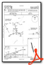
Instrument Approach Procedure (IAP) Charts
Nearby Airports with Instrument Procedures
| ID | Name | Heading / Distance | ||
|---|---|---|---|---|
 |
KABE | Lehigh Valley International Airport | 239° | 10.5 |
|
N85 | Alexandria Airport | 132° | 13.8 |
|
KXLL | Allentown Queen City Municipal Airport | 227° | 15.2 |
|
N40 | Sky Manor Airport | 131° | 16.0 |
|
1N7 | Blairstown Airport | 039° | 17.7 |
|
KUKT | Quakertown Airport | 199° | 19.5 |
|
KCKZ | Pennridge Airport | 185° | 21.3 |
|
22N | Jake Arner Memorial Airport | 279° | 24.0 |
|
KMPO | Pocono Mountains Regional Airport | 345° | 24.5 |
|
N51 | Solberg/Hunterdon Airport | 112° | 25.0 |
|
KDYL | Doylestown Airport | 167° | 25.1 |
|
KSMQ | Somerset Airport | 104° | 27.1 |
")
")


