Login
Register


77S
Hobby Field Airport
Official FAA Data Effective 2025-12-25 0901Z
Chart Supplement

VFR Chart of 77S
Sectional Charts at SkyVector.com
IFR Chart of 77S
Enroute Charts at SkyVector.com
Location Information for 77S
Coordinates: N43°55.85' / W123°0.40'Located 01 miles NE of Creswell, Oregon on 96 acres of land. View all Airports in Oregon.
Surveyed Elevation is 541 feet MSL.
Operations Data
|
|
Airport Communications
| AWOS-3: | 119.275 Tel. 541 895 2349 |
|---|---|
| CASCADE APPROACH: | 119.6 |
| CASCADE DEPARTURE: | 119.6 |
| UNICOM: | 122.700 |
| CTAF: | 122.700 |
| ATIS at EUG (14.6 NW): | 125.225 |
| ASOS at EUG (14.7 NW): | 541-203-2648 |
| AWOS-3PT at CVO (36.4 N): | 135.775 541-754-0081 |
- APCH/DEP CTL SVC PRVDD BY SEATTLE ARTCC (ZSE) ON FREQS 125.8/291.7 (HORTON RCAG) WHEN CASCADE APCH CTL (EUG) CLSD.
Nearby Navigation Aids
|
| ||||||||||||||||||||||||||||||||||||||||||


Runway 16/34
| Dimensions: | 3102 x 60 feet / 945 x 18 meters | |
|---|---|---|
| Surface: | Asphalt in Excellent Condition | |
| Weight Limits: | S-12 | |
| Edge Lighting: | Medium Intensity | |
| Runway 16 | Runway 34 | |
| Coordinates: | N43°56.10' / W123°0.44' | N43°55.59' / W123°0.36' |
| Elevation: | 541.2 | 535.3 |
| Traffic Pattern: | Left | Left |
| Runway Heading: | 174° True | 354° True |
| Markings: | Non-Precision Instrument in good condition. | Non-Precision Instrument in good condition. |
| Glide Slope Indicator | P2L (3.60° Glide Path Angle) | P2L (4.00° Glide Path Angle) UNUSBL BYD 5 DEG RIGHT AND LEFT OF CNTRLN & BYD 1.5 NM FM THR. |
| REIL: | Yes | Yes |
| Obstacles: | 13 ft Tree 248 ft from runway, 125 ft right of center | 64 ft Trees 546 ft from runway, 175 ft left of center |
Services Available
| Fuel: | 100LL (blue), Jet-A |
|---|---|
| Transient Storage: | Tiedowns |
| Airframe Repair: | MAJOR |
| Engine Repair: | MAJOR |
| Bottled Oxygen: | NONE |
| Bulk Oxygen: | NONE |
| Other Services: | PILOT INSTRUCTION,PARACHUTE JUMP ACTIVITY,AIRCRAFT RENTAL |
Ownership Information
| Ownership: | Publicly owned | |
|---|---|---|
| Owner: | CITY OF CRESWELL | |
| PO BOX 276 | ||
| CRESWELL, OR 97426 | ||
| 541-895-2531 | ||
| Manager: | SHELLY HUMBLE | |
| 83501 N. MELTON ROAD | ||
| CRESWELL, OR 97426 | ||
| 541-895-2913 | ||
Other Remarks
- RWY 34 CALM WIND RWY.
- PAEW ADJ TO RWY 16/34 WKENDS 0800-1600.
- BIRDS ON AND INVOF ARPT. BE AWARE MOWING ADJ RWY16/34 WEEKDAYS.
- BE AWARE OF SKYDIVERS XNG RWY.
- PARACHUTE JUMP AREA LOCATED EAST SIDE OF ARPT.
- CTC NUMBER FOR INFO AND UPDATES ABOUT SKYDIVING OPS 541-895-3029.
- FOR CD CTC CASCADE APCH AT 541-607-4674/4675, WHEN APCH CLSD CTC SEATTLE ARTCC AT 253-351-3694.
- 0LL SELF SERVE FUEL AVAILABLE 24 HRS.
- ACTIVATE PAPI RWY 16 & 34; MIRL RWY 16/34.- CTAF.
Weather Minimums

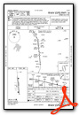
Instrument Approach Procedure (IAP) Charts
Departure Procedure Obstacles (DPO) Charts

Nearby Airports with Instrument Procedures
| ID | Name | Heading / Distance | ||
|---|---|---|---|---|
 |
KEUG | Mahlon Sweet Field Airport | 322° | 14.6 |
|
KCVO | Corvallis Municipal Airport | 340° | 36.1 |
|
S12 | Albany Municipal Airport | 356° | 42.5 |
|
KRBG | Roseburg Regional Airport | 200° | 44.2 |
|
KSLE | Mcnary Field Airport | 000° | 58.7 |
|
KONP | Newport Municipal Airport | 311° | 59.8 |
|
KOTH | Southwest Oregon Regional Airport | 240° | 62.2 |
|
S21 | Sunriver Airport | 092° | 67.5 |
|
KMMV | Mc Minnville Municipal Airport | 355° | 76.0 |
|
KBDN | Bend Municipal Airport | 082° | 78.8 |
|
KUAO | Aurora State Airport | 007° | 79.6 |
|
KRDM | Roberts Field Airport | 075° | 82.6 |
Airport Images

By: takewing2015


