Login
Register
RDM
Roberts Field Airport
Official FAA Data Effective 2025-12-25 0901Z
VFR Chart of KRDM
Sectional Charts at SkyVector.com
IFR Chart of KRDM
Enroute Charts at SkyVector.com
Location Information for KRDM
Coordinates: N44°15.24' / W121°9.00'Located 01 miles SE of Redmond, Oregon on 2518 acres of land. View all Airports in Oregon.
Surveyed Elevation is 3081 feet MSL.
Operations Data
|
|
Airport Communications
| ATIS: | 119.025 (541-548-1742) |
|---|---|
| ASOS: | 119.025 Tel. 541-504-8743 |
| REDMOND TOWER: | 124.5 256.8 |
| REDMOND GROUND: | 121.8 |
| CTAF: | 124.500 |
| UNICOM: | 122.950 |
| AWOS-3 at BDN (9.4 S): | 134.425 541-382-1477 |
| AWOS-3PT at S39 (10.9 E): | 118.325 541-447-4060 |
| AWOS-3PT at S33 (24.7 N): | 132.425 541-475-0494 |
- APCH/DEP CTL SVC PRVDD BY SEATTLE ARTCC (ZSE) ON FREQS126.15/269.475 (REDMOND RCAG).
- ATC RADAR SVC PRVDD WITHIN 40 NM RADIUS BY SEATTLE ARTCC TO TRANSPONDER EQUIPPED ACFT ONLY. RDM ATCT DOES NOT PROVIDE ATC RADAR SVC.
Nearby Navigation Aids
|
| ||||||||||||||||||||||||||||||
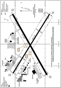
Runway 05/23
| Dimensions: | 7038 x 150 feet / 2145 x 46 meters | |
|---|---|---|
| Surface: | Asphalt / Grooved in Good Condition | |
| Weight Limits: | S-120, D-216, ST-399
PCR VALUE: 530/F/A/X/T
| |
| Edge Lighting: | High Intensity | |
| Runway 05 | Runway 23 | |
| Coordinates: | N44°14.97' / W121°9.71' | N44°15.54' / W121°8.31' |
| Elevation: | 3074.1 | 3053.9 |
| Traffic Pattern: | Left | Left |
| Runway Heading: | 60° True | 240° True |
| Declared Distances: | TORA:7038 TODA:7038 ASDA:7038 LDA:7038 | TORA:7038 TODA:7038 ASDA:7031 LDA:7031 |
| Markings: | Precision Instrument in good condition. | Precision Instrument in good condition. |
| Glide Slope Indicator | V4L (3.00° Glide Path Angle) | P4L (3.00° Glide Path Angle) |
| Approach Lights: | MALSR 1,400 Foot Medium-intensity Approach Lighting System with runway alignment indicator lights. | |
| REIL: | Yes | |
Runway 11/29
| Dimensions: | 7006 x 100 feet / 2135 x 30 meters | |
|---|---|---|
| Surface: | Asphalt / Grooved in Good Condition | |
| Weight Limits: | S-109, D-178
PCR VALUE: 530/F/A/X/T
| |
| Edge Lighting: | Medium Intensity | |
| Runway 11 | Runway 29 | |
| Coordinates: | N44°15.54' / W121°9.67' | N44°14.93' / W121°8.31' |
| Elevation: | 3047.2 | 3081.4 |
| Runway Heading: | 122° True | 302° True |
| Declared Distances: | TORA:7006 TODA:7006 ASDA:7006 LDA:7006 | TORA:7006 TODA:7006 ASDA:7006 LDA:7006 |
| Markings: | Non-Precision Instrument in good condition. | Non-Precision Instrument in good condition. |
| Glide Slope Indicator | P4L (3.00° Glide Path Angle) | P4L (3.00° Glide Path Angle) UNUSBL BYD 5.0 NM FM THD, DOES NOT PRVD OBSTN CLNC. |
| REIL: | Yes | Yes |
Helipad H1
PVT USE HELIPAD, CTC TWR. WHEN TWR CLSD USE CTAF. | ||
| Dimensions: | 48 x 48 feet / 15 x 15 meters | |
|---|---|---|
| Surface: | Concrete | |
| Coordinates: | N44°15.62' / W121°8.45' | N0°0.00' / E0°0.00' |
| Elevation: | 3056.0 | |
Services Available
| Fuel: | 100LL (blue), Jet-A |
|---|---|
| Transient Storage: | Hangars,Tiedowns |
| Airframe Repair: | MAJOR |
| Engine Repair: | MAJOR |
| Bottled Oxygen: | HIGH/LOW |
| Bulk Oxygen: | HIGH/LOW |
| Other Services: | AIR FREIGHT SERVICES,AIR AMBULANCE SERVICES,AVIONICS,CARGO HANDLING SERVICES,CHARTER SERVICE,PILOT INSTRUCTION,AIRCRAFT RENTAL LIFE FLIGHT |
Ownership Information
| Ownership: | Publicly owned | |
|---|---|---|
| Owner: | CITY OF REDMOND | |
| 411 SW 9TH STREET | ||
| REDMOND, OR 97756-0100 | ||
| (541) 504-3085 | ||
| Manager: | ZACHARY BASS | |
| 2522 SE JESSE BUTLER CIRCLE #17 | ||
| REDMOND, OR 97756-8643 | ||
| (541) 504-3085 | ||
Other Remarks
- TRANSIENT HELICOPTER OPS PREFERRED NORTH (CONCRETE) GENERAL AVIATION RAMP.
- FOR CD IF UNA TO CTC ON FSS FREQ, CTC SEATTLE ARTCC AT 253-351-3694.
- COLD TEMPERATURE AIRPORT. ALTITUDE CORRECTION REQUIRED AT OR BELOW -16C.
- PILOTS CONDUCTING EFVS OPS; BE AWARE LED ALS IN USE RWY 23.
- OCNL WILDLIFE ON AND INVOF ARPT.
- TERMINAL APRON NOT AVBL FOR GENERAL AVIATION ACFT.
- BY APPOINTMENT ONLY
- WHEN ATCT CLSD ACTVT HIRL RY 05/23, MIRL RY 11/29, MALSR RY 23, REIL RY 05, 11 & 29, AND TWY LGTS - CTAF.
Weather Minimums
Instrument Approach Procedure (IAP) Charts
Departure Procedure (DP) Charts
Nearby Airports with Instrument Procedures
| ID | Name | Heading / Distance | ||
|---|---|---|---|---|
 |
KBDN | Bend Municipal Airport | 192° | 9.8 |
 |
S39 | Prineville Airport | 079° | 10.7 |
 |
S33 | Madras Municipal Airport | 359° | 25.0 |
 |
S21 | Sunriver Airport | 210° | 26.2 |
 |
62S | Christmas Valley Airport | 160° | 64.6 |
 |
KDLS | Columbia Gorge Regional/The Dalles Municipal Airport | 359° | 81.9 |
 |
77S | Hobby Field Airport | 257° | 82.6 |
 |
S12 | Albany Municipal Airport | 286° | 85.2 |
 |
KSLE | Mcnary Field Airport | 296° | 88.6 |
 |
KEUG | Mahlon Sweet Field Airport | 265° | 89.4 |
 |
KUAO | Aurora State Airport | 311° | 91.4 |
 |
KCVO | Corvallis Municipal Airport | 279° | 93.2 |


