Login
Register


CVO
Corvallis Municipal Airport
Official FAA Data Effective 2026-02-19 0901Z
Chart Supplement

VFR Chart of KCVO
Sectional Charts at SkyVector.com
IFR Chart of KCVO
Enroute Charts at SkyVector.com
Location Information for KCVO
Coordinates: N44°29.81' / W123°17.37'Located 04 miles SW of Corvallis, Oregon on 1490 acres of land. View all Airports in Oregon.
Surveyed Elevation is 249 feet MSL.
Operations Data
|
|
Airport Communications
| AWOS-3PT: | 135.775 Tel. 541-754-0081 |
|---|---|
| CASCADE APPROACH: | 127.5 348.7 |
| CASCADE DEPARTURE: | 127.5 348.7 |
| UNICOM: | 123.075 |
| CTAF: | 123.075 |
| AWOS-3PT at S12 (13.1 NE): | 119.925 541-967-3508 |
| ATIS at EUG (22.6 S): | 125.225 |
| ASOS at EUG (22.6 S): | 541-203-2648 |
- APCH/DEP CTL SVC PRVDD BY SEATTLE ARTCC (ZSE) ON FREQ 125.8/291.7 (HORTON RCAG) WHEN CASCADE APCH CTL (EUG) CLSD.
Nearby Navigation Aids
|
| ||||||||||||||||||||||||||||||||||||||||||


Runway 17/35
| Dimensions: | 5900 x 150 feet / 1798 x 46 meters | |
|---|---|---|
| Surface: | Asphalt in Excellent Condition | |
| Weight Limits: | S-35, D-73, ST-100 | |
| Edge Lighting: | High Intensity | |
| Runway 17 | Runway 35 | |
| Coordinates: | N44°30.21' / W123°17.46' | N44°29.24' / W123°17.63' |
| Elevation: | 244.6 | 248.9 |
| Runway Heading: | 187° True | 7° True |
| Declared Distances: | TORA:5900 TODA:5900 ASDA:5900 LDA:5900 | TORA:5900 TODA:5900 ASDA:5900 LDA:5900 |
| Markings: | Precision Instrument in good condition. | Non-Precision Instrument in good condition. |
| Glide Slope Indicator | V4L (3.00° Glide Path Angle) | V4L (3.00° Glide Path Angle) |
| Approach Lights: | MALSR 1,400 Foot Medium-intensity Approach Lighting System with runway alignment indicator lights. | |
| REIL: | Yes | |
Runway 10/28
| Dimensions: | 3100 x 75 feet / 945 x 23 meters | |
|---|---|---|
| Surface: | Asphalt in Excellent Condition | |
| Weight Limits: | S-51, D-65, ST-100 | |
| Edge Lighting: | Medium Intensity | |
| Runway 10 | Runway 28 | |
| Coordinates: | N44°30.07' / W123°17.36' | N44°29.88' / W123°16.70' |
| Elevation: | 245.7 | 246.1 |
| Traffic Pattern: | Left | Left |
| Runway Heading: | 112° True | 292° True |
| Displaced Threshold: | 228 Feet | |
| Declared Distances: | TORA:3100 TODA:3100 ASDA:3100 LDA:3100 | TORA:3100 TODA:3100 ASDA:3100 LDA:2872 |
| Markings: | Basic in good condition. | Basic in good condition. |
| Glide Slope Indicator | P4L (3.00° Glide Path Angle) | |
| Obstacles: | 21 ft Railroad 380 ft from runway APCH RATIO 29:1 FM DSPLCD THR. |
|
Services Available
| Fuel: | 100LL (blue), Jet-A |
|---|---|
| Transient Storage: | Hangars,Tiedowns |
| Airframe Repair: | MAJOR |
| Engine Repair: | MAJOR |
| Bottled Oxygen: | HIGH |
| Bulk Oxygen: | HIGH/LOW |
| Other Services: | AIR FREIGHT SERVICES,AIR AMBULANCE SERVICES,CHARTER SERVICE,PILOT INSTRUCTION,AIRCRAFT RENTAL,AIRCRAFT SALES,ANNUAL SURVEYING |
Ownership Information
| Ownership: | Publicly owned | |
|---|---|---|
| Owner: | CITY OF CORVALLIS | |
| PUBLIC WORKS DEPT | ||
| CORVALLIS, OR 97339 | ||
| 541-766-6916 | ||
| Manager: | CITY OF CORVALLIS | |
| PO BOX 1083 | ||
| CORVALLIS, OR 97339-1083 | ||
| 541-228-5523 | ||
Other Remarks
- MIGRATORY WATERFOWL & OTR BIRDS ON & INVOF ARPT.
- SURF COND NOT RPRT DLY 1700-0800 AND ALL TIMES SATURDAYS AND SUNDAYS.
- FOR CD CTC CASCADE APCH AT 541-607-4674/4675, WHEN APCH CLSD CTC SEATTLE ARTCC AT 253-351-3694.
- RWY 10/28 HAS WHITE SIDE STRIPES.
- ACTVT MALSR RWY 17, REIL RWY 35; VASI RWY 17 & 35; PAPI RWY 28; CTAF. ACTVT HIRL 17/35 AND MIRL 10/28 SS-SR CTAF.
Weather Minimums


Instrument Approach Procedure (IAP) Charts

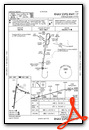
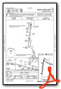
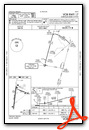

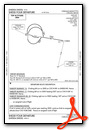
Departure Procedure (DP) Charts
Nearby Airports with Instrument Procedures
| ID | Name | Heading / Distance | ||
|---|---|---|---|---|
 |
S12 | Albany Municipal Airport | 049° | 13.0 |
|
KEUG | Mahlon Sweet Field Airport | 171° | 22.6 |
|
KSLE | Mcnary Field Airport | 026° | 27.6 |
|
KONP | Newport Municipal Airport | 278° | 33.4 |
|
77S | Hobby Field Airport | 160° | 36.1 |
|
KMMV | Mc Minnville Municipal Airport | 008° | 42.4 |
|
KUAO | Aurora State Airport | 026° | 50.2 |
|
KTMK | Tillamook Airport | 338° | 59.6 |
|
KHIO | Portland-Hillsboro Airport | 012° | 64.4 |
|
KPDX | Portland International Airport | 023° | 71.8 |
|
KVUO | Pearson Field Airport | 021° | 72.6 |
|
KTTD | Portland-Troutdale Airport | 030° | 73.6 |


