Login
Register


7V7
Red Cloud Municipal Airport
Official FAA Data Effective 2026-02-19 0901Z
Chart Supplement

VFR Chart of 7V7
Sectional Charts at SkyVector.com
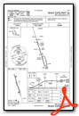
IFR Chart of 7V7
Enroute Charts at SkyVector.com
Location Information for 7V7
Coordinates: N40°4.93' / W98°32.48'Located 01 miles W of Red Cloud, Nebraska on 164 acres of land. View all Airports in Nebraska.
Surveyed Elevation is 1744 feet MSL.
Operations Data
|
|
Airport Communications
| CTAF: | 122.900 |
|---|---|
| AWOS-3PT at K82 (22.6 SW): | 118.450 785-282-8326 |
| ASOS at HSI (31.8 N): | 120.525 402-463-4029 |
| AWOS-2 at K75 (39.5 S): | 120.025 785-345-4998 |
- APCH/DEP SVC PRVDD BY MINNEAPOLIS ARTCC ON FREQS. 119.4/278.8 (HASTINGS RCAG).
Nearby Navigation Aids
|
| ||||||||||||||||||||||||||||||||||||||||||||||||||||||||||||


Runway 16/34
| Dimensions: | 3702 x 60 feet / 1128 x 18 meters | |
|---|---|---|
| Surface: | Concrete in Excellent Condition | |
| Weight Limits: | S-12 | |
| Edge Lighting: | Medium Intensity | |
| Runway 16 | Runway 34 | |
| Coordinates: | N40°5.22' / W98°32.60' | N40°4.64' / W98°32.36' |
| Elevation: | 1744.4 | 1717.4 |
| Traffic Pattern: | Left | Left |
| Runway Heading: | 163° True | 343° True |
| Markings: | Non-Precision Instrument in good condition. | Non-Precision Instrument in good condition. |
| Glide Slope Indicator | P2L (3.25° Glide Path Angle) | P2L (3.00° Glide Path Angle) |
| REIL: | Yes | Yes |
| Obstacles: | 47 ft Tree 1123 ft from runway, 252 ft right of center | |
Services Available
| Fuel: | 100LL (blue) |
|---|---|
| Transient Storage: | Tiedowns |
| Airframe Repair: | NONE |
| Engine Repair: | NONE |
| Bottled Oxygen: | NONE |
| Bulk Oxygen: | NONE |
| Other Services: | CROP DUSTING SERVICES |
Ownership Information
| Ownership: | Publicly owned | |
|---|---|---|
| Owner: | RED CLOUD AIRPORT AUTHORITY | DAYRE WILLIAMS CHAIRMAN. |
| 241 WEST 4TH AVENUE | ||
| RED CLOUD, NE 68970-2357 | ||
| 402-746-2500 | ||
| Manager: | DAYRE WILLIAMS | |
| 241 WEST 4TH AVENUE | ||
| RED CLOUD, NE 68970-2357 | ||
| 402-746-2500 | ||
Other Remarks
- FOR CD CTC MINNEAPOLIS ARTCC AT 651-463-5588.
- COURTESY CAR AVBL.
- 0LL FOR FUEL CALL 402- 746-2500 OR 746-3818.
- DUSK-2300. MIRL RY 16/34 PRESET ON LOW INTST AND REIL RY 16/34 ON DUSK-2300; TO INCR INTST AND ACTVT PAPI RY 16/34 - CTAF; AFTER 2300 ACTVT MIRL RY 16/34, PAPI RY 16/34 AND REIL RY 16/34 - CTAF. FROM SR TO SS ACTVT PAPI RY 16/34 - CTAF.
Weather Minimums

Instrument Approach Procedure (IAP) Charts

Nearby Airports with Instrument Procedures
| ID | Name | Heading / Distance | ||
|---|---|---|---|---|
 |
12K | Superior Municipal Airport | 095° | 22.2 |
|
K82 | Smith Center Municipal Airport | 211° | 22.4 |
|
KHSI | Hastings Municipal Airport | 009° | 31.8 |
|
0V3 | Pioneer Village Field Airport | 324° | 31.9 |
|
4D9 | Alma Municipal Airport | 273° | 37.1 |
|
08K | Harvard State Airport | 031° | 40.2 |
|
K61 | Moritz Memorial Airport | 152° | 41.3 |
|
KPHG | Phillipsburg Municipal Airport | 240° | 41.4 |
|
KHDE | Brewster Field Airport | 301° | 42.7 |
|
KRPB | Belleville Municipal Airport | 111° | 43.7 |
|
KHJH | Hebron Municipal Airport | 084° | 44.2 |
|
KEAR | Kearney Regional Airport | 331° | 44.2 |
Airport Images
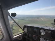
By: Big Orange Bird


