Login
Register


HDE
Brewster Field Airport
Official FAA Data Effective 2026-01-22 0901Z
Chart Supplement

VFR Chart of KHDE
Sectional Charts at SkyVector.com
IFR Chart of KHDE
Enroute Charts at SkyVector.com
Location Information for KHDE
Coordinates: N40°27.11' / W99°20.16'Located 02 miles NE of Holdrege, Nebraska on 398 acres of land. View all Airports in Nebraska.
Surveyed Elevation is 2313 feet MSL.
Operations Data
|
|
Airport Communications
| AWOS-3: | 121.325 Tel. 308-995-6433 |
|---|---|
| UNICOM: | 122.800 |
| CTAF: | 122.800 |
| AWOS-3PT at EAR (22.3 NE): | 123.875 308-237-5608 |
| AWOS-3 at LXN (28.6 NW): | 121.025 308-324-5975 |
| AWOS-3PT at CSB (38.7 W): | 118.375 308-697-4279 |
- APCH/DEP CTL SVC PRVDD BY DENVER ARTCC (ZDV) ON FREQS 132.7/226.675 (GRAND ISLAND WEST RCAG).
Nearby Navigation Aids
|
| ||||||||||||||||||||||||||||||||||||||||||||||||||||||


Runway 18/36
| Dimensions: | 4701 x 75 feet / 1433 x 23 meters | |
|---|---|---|
| Surface: | Asphalt-Concrete in Good Condition S 3100 FT & CENTER 50 FT ASPH. | |
| Weight Limits: | S-30 | |
| Edge Lighting: | Medium Intensity | |
| Runway 18 | Runway 36 | |
| Coordinates: | N40°27.54' / W99°20.16' | N40°26.78' / W99°20.32' |
| Elevation: | 2305.9 | 2307.8 |
| Traffic Pattern: | Left | Left |
| Runway Heading: | 190° True | 10° True |
| Markings: | Non-Precision Instrument in good condition. | Non-Precision Instrument in good condition. |
| Glide Slope Indicator | P2L (3.00° Glide Path Angle) | P2L (3.00° Glide Path Angle) |
| REIL: | Yes | Yes |
Runway 11/29
| Dimensions: | 2429 x 300 feet / 740 x 91 meters | |
|---|---|---|
| Surface: | Turf in Fair Condition | |
| Runway 11 | Runway 29 | |
| Coordinates: | N40°27.12' / W99°20.22' | N40°26.89' / W99°19.80' |
| Elevation: | 2307.3 | 2312.9 |
| Traffic Pattern: | Left | Left |
| Runway Heading: | 126° True | 306° True |
Services Available
| Fuel: | 100LL (blue), Jet-A |
|---|---|
| Transient Storage: | Hangars,Tiedowns |
| Airframe Repair: | MAJOR |
| Engine Repair: | MAJOR |
| Bottled Oxygen: | HIGH |
| Bulk Oxygen: | NONE AVIATORS BREATHING OXYGEN 2000 PSI - BOTTLES CAN BE TOPPED OFF |
| Other Services: | CROP DUSTING SERVICES,PILOT INSTRUCTION,AIRCRAFT RENTAL,ANNUAL SURVEYING AIRCRAFT RENTALS FROM INSTRUCTORS ONLY |
Ownership Information
| Ownership: | Publicly owned | |
|---|---|---|
| Owner: | HOLDREGE AIRPORT AUTHORITY | |
| 1320 BREWSTER ROAD | ||
| HOLDREGE, NE 68949-1571 | ||
| 308-991-1455 | DOROTHY ANDERSON CHAIRMAN. | |
| Manager: | DAN POWERS | |
| 1320 BREWSTER ROAD | ||
| HOLDREGE, NE 68949-1571 | ||
| (308) 991-3641 | ||
Other Remarks
- WATERFOWL INVOF ARPT.
- EXTENSIVE CROP SPRAYING OPNS INVOF ARPT APR THRU AUG.
- RWY 11/29 NOT PLOWED WINT MONTHS.
- RWY 18 DSGND CALM WND RWY.
- FOR CD CTC DENVER ARTCC AT 303-651-4257.
- RWY 11 /29 MKD; BOUNDARY CONES ON RWY ENDS.
- 0LL 100LL 24 HR SELF SVC FUEL AVBL VIA CREDIT CARD SYSTEM.
- CALL FOR JET A SERVICE. FOR SERVICE AND ATTENDANT AFTER HOURS CALL 308-995-7895. IF NO ANSWER, CALL 308-991-5803.
- MIRL RWY 18/36 PRESET LOW INTST; TO INCR INTST & ACTVT REIL & PAPI RWYS 18 & 36 - CTAF.
Weather Minimums

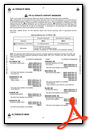
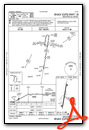
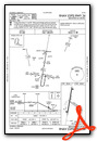
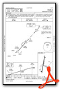
Instrument Approach Procedure (IAP) Charts
Nearby Airports with Instrument Procedures
| ID | Name | Heading / Distance | ||
|---|---|---|---|---|
 |
0V3 | Pioneer Village Field Airport | 077° | 18.3 |
|
4D9 | Alma Municipal Airport | 181° | 20.4 |
|
KEAR | Kearney Regional Airport | 042° | 22.3 |
|
KLXN | Jim Kelly Field Airport | 315° | 28.6 |
|
KCSB | Cambridge Municipal Airport | 257° | 38.9 |
|
KCZD | Cozad Municipal Airport | 309° | 39.5 |
|
KHSI | Hastings Municipal Airport | 077° | 42.6 |
|
7V7 | Red Cloud Municipal Airport | 121° | 42.7 |
|
KPHG | Phillipsburg Municipal Airport | 178° | 42.9 |
|
KNRN | Norton Municipal Airport | 215° | 44.3 |
|
KGTE | Gothenburg Municipal Airport | 307° | 46.6 |
|
K82 | Smith Center Municipal Airport | 148° | 48.3 |
Airport Images
Do you have a recent image of this airport? Upload it here!


