Login
Register


RPB
Belleville Municipal Airport
Official FAA Data Effective 2026-02-19 0901Z
Chart Supplement

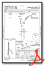
VFR Chart of KRPB
Sectional Charts at SkyVector.com
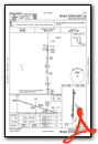
IFR Chart of KRPB
Enroute Charts at SkyVector.com
Location Information for KRPB
Coordinates: N39°49.07' / W97°39.58'Located 01 miles W of Belleville, Kansas on 111 acres of land. View all Airports in Kansas.
Surveyed Elevation is 1538 feet MSL.
Operations Data
|
|
Airport Communications
| UNICOM: | 122.800 |
|---|---|
| CTAF: | 122.800 |
| ASOS at CNK (16.0 S): | 123.825 785-262-9693 |
| AWOS-3 at HJH (20.2 N): | 118.525 402-768-2501 |
| AWOS-3PT at K61 (30.0 SW): | 118.225 785-378-4173 |
- APCH/DEP SVC PRVDD BY MINNEAPOLIS ARTCC (ZMP) ON FREQ 126.4/317.7 (MARYSVILLE RCAG).
Nearby Navigation Aids
|
| ||||||||||||||||||||||||||||||||||||||||||||||||||||||


Runway 18/36
| Dimensions: | 3500 x 60 feet / 1067 x 18 meters | |
|---|---|---|
| Surface: | Asphalt in Good Condition | |
| Weight Limits: | S-12, D-18 | |
| Edge Lighting: | Medium Intensity | |
| Runway 18 | Runway 36 | |
| Coordinates: | N39°49.39' / W97°39.61' | N39°48.81' / W97°39.63' |
| Elevation: | 1524.0 | 1538.0 |
| Traffic Pattern: | Left | Left |
| Runway Heading: | 182° True | 2° True |
| Markings: | Non-Precision Instrument in good condition. | Non-Precision Instrument in good condition. |
| Glide Slope Indicator | P2L (3.00° Glide Path Angle) | P2L (3.00° Glide Path Angle) |
| Obstacles: | 40 ft Trees 315 ft from runway, 155 ft left of center ALSO 35 FT TREES, 400 FT DSTC, 165 FT L/R, OBSTN CLNC SLP 11:1. 25 FT TREES, 100-199 FT DSTC, 154 FT L. |
6 ft Road 280 ft from runway, 295 ft right of center |
Runway 14/32
| Dimensions: | 1415 x 100 feet / 431 x 30 meters | |
|---|---|---|
| Surface: | Turf in Good Condition SFC ROUGH. | |
| Runway 14 | Runway 32 | |
| Coordinates: | N39°49.06' / W97°39.56' | N39°48.88' / W97°39.37' |
| Elevation: | 1520.0 | 1523.0 |
| Traffic Pattern: | Left | Left |
| Runway Heading: | 141° True | 321° True |
| Markings: | Non-Standard | Non-Standard |
| Obstacles: | CONTROLLING OBSTN EXCEEDS A 45 DEG SLP. |
10 ft Road 0 ft from runway, 70 ft right of center |
Services Available
| Fuel: | 100LL (blue) |
|---|---|
| Transient Storage: | Hangars,Tiedowns |
| Airframe Repair: | NOT AVAILABLE |
| Engine Repair: | NOT AVAILABLE |
| Bottled Oxygen: | NONE |
| Bulk Oxygen: | NONE |
| Other Services: | CROP DUSTING SERVICES |
Ownership Information
| Ownership: | Publicly owned | |
|---|---|---|
| Owner: | CITY OF BELLEVILLE | |
| 1819 L ST | ||
| BELLEVILLE, KS 66935 | ||
| 785-527-2288 | ||
| Manager: | BRIAN PHILLIPS | |
| 1819 L ST | ||
| BELLEVILLE, KS 66935 | ||
| 785-527-3134 | ||
Other Remarks
- FOR CD CTC MINNEAPOLIS ARTCC AT 651-463-5588.
- THLD MKD W/2 YELLOW CONES.
- THLD MKD W/2 "L" SHAPED MARKERS.
- ACTVT PAPI RWY 18 & 36; MIRL 18/36 - CTAF
Weather Minimums

Instrument Approach Procedure (IAP) Charts
Nearby Airports with Instrument Procedures
| ID | Name | Heading / Distance | ||
|---|---|---|---|---|
 |
KCNK | Blosser Municipal Airport | 178° | 16.1 |
|
KHJH | Hebron Municipal Airport | 009° | 20.3 |
|
12K | Superior Municipal Airport | 306° | 23.0 |
|
K38 | Washington County Veteran's Memorial Airport | 099° | 28.7 |
|
K61 | Moritz Memorial Airport | 226° | 30.1 |
|
KFBY | Fairbury Municipal Airport | 045° | 31.5 |
|
KCYW | Clay Center Municipal Airport | 137° | 34.8 |
|
7V7 | Red Cloud Municipal Airport | 291° | 43.7 |
|
KFMZ | Fairmont State Airport | 004° | 46.2 |
|
KMYZ | Marysville Municipal Airport | 086° | 47.6 |
|
KBIE | Beatrice Municipal Airport | 054° | 50.8 |
|
K82 | Smith Center Municipal Airport | 266° | 52.6 |
Airport Images
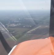
By: Big Orange Bird


