Login
Register
8VG4
Buffalo Ridge Airport
Official FAA Data Effective 2025-11-27 0901Z
VFR Chart of 8VG4
Sectional Charts at SkyVector.com
IFR Chart of 8VG4
Enroute Charts at SkyVector.com
Location Information for 8VG4
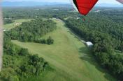
Coordinates: N37°36.32' / W79°0.98'Located 02 miles NE of Amherst, Virginia on 73 acres of land. View all Airports in Virginia.
Estimated Elevation is 660 feet MSL.
Operations Data
|
|
Airport Communications
| ATIS at LYH (19.0 SW): | 119.8 |
|---|---|
| ASOS at LYH (19.3 SW): | 434-205-0756 |
| AWOS-3 at 0V4 (27.9 S): | 120.575 434-283-7826 |
Nearby Navigation Aids
|
| ||||||||||||||||||||||||||||||||||||||||||||||||||||||||||||
Runway 16/34
| Dimensions: | 1700 x 50 feet / 518 x 15 meters | |
|---|---|---|
| Surface: | Turf | |
| Runway 16 | Runway 34 | |
| Traffic Pattern: | Right | |
Runway 10/28
| Dimensions: | 1200 x 50 feet / 366 x 15 meters | |
|---|---|---|
| Surface: | Turf | |
| Runway 10 | Runway 28 | |
| Traffic Pattern: | Right | |
Ownership Information
| Ownership: | Privately Owned | |
|---|---|---|
| Owner: | BUFFALO RIDGE AIRPORTS | |
| 202 SALISBURY CIR | ||
| LYNCHBURG, VA 24502 | ||
| 434-841-0074 | ||
| Manager: | RON DIXON | |
| 202 SALISBURY CIR | ||
| LYNCHBURG, VA 24502 | ||
| 434-841-0074 | ||
Other Remarks
- EXER CTN WHEN ENTERING LDG PAT. OCNL AERO TOWING OF HANG GLIDERS TO 2000+ FT INVOF ARPT. LDGNG GLDS HAVE RIGHT OF WAY. FREQ FLT TRNG EXERCICSES IN PAT IN WT SHIFT CTL LAND VEHICLES (TRIKES).
- FOR CD CTC WASHINGTON ARTCC AT 703-771-3587.
Nearby Airports with Instrument Procedures
| ID | Name | Heading / Distance | ||
|---|---|---|---|---|
 |
W24 | Falwell Airport | 200° | 14.5 |
 |
KLYH | Lynchburg Regional/Preston Glenn Field Airport | 207° | 19.0 |
 |
W90 | New London Airport | 217° | 25.2 |
 |
0V4 | Brookneal/Campbell County Airport | 180° | 27.8 |
 |
W13 | Eagle's Nest Airport | 006° | 28.5 |
 |
KFVX | Farmville Regional Airport | 118° | 31.4 |
 |
KSHD | Shenandoah Valley Regional Airport | 008° | 39.9 |
 |
W91 | Smith Mountain Lake Airport | 222° | 40.6 |
 |
KCHO | Charlottesville-Albemarle Airport | 039° | 41.8 |
 |
KHSP | Ingalls Field Airport | 298° | 44.1 |
 |
KVBW | Bridgewater Air Park Airport | 003° | 45.6 |
 |
KROA | Roanoke/Blacksburg Regional (Woodrum Field) Airport | 250° | 48.8 |


