Login
Register
CHO
Charlottesville-Albemarle Airport
Official FAA Data Effective 2025-12-25 0901Z
VFR Chart of KCHO
Sectional Charts at SkyVector.com
IFR Chart of KCHO
Enroute Charts at SkyVector.com
Location Information for KCHO
Coordinates: N38°8.38' / W78°27.14'Located 07 miles N of Charlottesville, Virginia on 710 acres of land. View all Airports in Virginia.
Surveyed Elevation is 640 feet MSL.
Operations Data
|
|
Airport Communications
| ATIS: | 118.425 |
|---|---|
| ASOS: | Tel. 434-975-0110 |
| CHARLOTTESVILLE TOWER: | 124.5 338.275 |
| CHARLOTTESVILLE GROUND: | 121.9 338.275 |
| POTOMAC APPROACH: | 120.525 132.85 323.125 |
| POTOMAC DEPARTURE: | 120.525 132.85 323.125 |
| EMERG: | 121.5 243.0 |
| CTAF: | 124.500 |
| UNICOM: | 122.950 |
| AWOS-3 at GVE (13.6 E): | 120.225 540-832-2095 |
| AWOS-3 at OMH (20.3 E): | 118.075 540-672-0505 |
| AWOS-3 at SHD (22.4 W): | 124.925 540-234-0110 |
Nearby Navigation Aids
|
| ||||||||||||||||||||||||||||||||||||||||||||||||||||||||||||
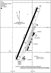
Runway 03/21
| Dimensions: | 6801 x 150 feet / 2073 x 46 meters | |
|---|---|---|
| Surface: | Asphalt / Grooved in Good Condition | |
| Weight Limits: | S-89, D-114, ST-171
PCR VALUE: 360/F/D/X/T
| |
| Edge Lighting: | High Intensity | |
| Runway 03 | Runway 21 | |
| Coordinates: | N38°7.86' / W78°27.41' | N38°8.90' / W78°26.87' |
| Elevation: | 640.1 | 618.3 |
| Traffic Pattern: | Left | Left |
| Runway Heading: | 22° True | 202° True |
| Declared Distances: | TORA:6801 TODA:6801 ASDA:6801 LDA:6801 | TORA:6801 TODA:6801 ASDA:6801 LDA:6801 |
| Markings: | Precision Instrument in good condition. | Non-Precision Instrument in good condition. |
| Glide Slope Indicator | P4L (3.00° Glide Path Angle) | P4R (3.00° Glide Path Angle) UNUSBL BYD 6.5 DEG L OF RCL. |
| Approach Lights: | MALSR 1,400 Foot Medium-intensity Approach Lighting System with runway alignment indicator lights. | |
| REIL: | Yes | |
Services Available
| Fuel: | 100LL (blue), Jet-A |
|---|---|
| Transient Storage: | Hangars,Tiedowns |
| Airframe Repair: | MAJOR |
| Engine Repair: | MAJOR |
| Bottled Oxygen: | NONE |
| Bulk Oxygen: | NONE |
| Other Services: | CHARTER SERVICE,PILOT INSTRUCTION,AIRCRAFT RENTAL |
Ownership Information
| Ownership: | Publicly owned | |
|---|---|---|
| Owner: | CHRLTSVL-ALBMRL ARPT AUTH | |
| 100 BOWEN LOOP, SUITE 200 | ||
| CHARLOTTESVILLE, VA 22911 | ||
| 434-973-8341 | ||
| Manager: | JASON BURCH | X104. |
| 100 BOWEN LOOP, SUITE 200 | ||
| CHARLOTTESVILLE, VA 22911 | ||
| 434-973-8342 | ||
Other Remarks
- DEER & BIRDS ON & INVOF ARPT.
- FOR CD WHEN ATCT IS CLSD CTC POTOMAC APCH AT 866-640-4124.
- FOR ACFT SVCS CTC 126.925.
- WHEN ATCT CLSD HIRL RWY 03/21, & TWY LIGHTS PRESET LOW INTST. TO ACTVT & INCREASE INTST MALSR RWY 03; REIL RWY 21; HIRL RWY 03/21 & TWY LIGHTS - CTAF.
Weather Minimums
Instrument Approach Procedure (IAP) Charts
Nearby Airports with Instrument Procedures
| ID | Name | Heading / Distance | ||
|---|---|---|---|---|
 |
KGVE | Gordonsville Municipal Airport | 085° | 13.6 |
 |
KOMH | Orange County Airport | 071° | 20.3 |
 |
KSHD | Shenandoah Valley Regional Airport | 289° | 22.3 |
 |
W13 | Eagle's Nest Airport | 260° | 23.6 |
 |
KLKU | Louisa County/Freeman Field Airport | 108° | 24.1 |
 |
KVBW | Bridgewater Air Park Airport | 299° | 27.5 |
 |
KLUA | Luray Caverns Airport | 355° | 31.7 |
 |
8W2 | New Market Airport | 338° | 33.2 |
 |
7W4 | Lake Anna Airport | 107° | 35.1 |
 |
KCJR | Culpeper Regional Airport | 050° | 36.3 |
 |
KHWY | Warrenton/Fauquier Airport | 052° | 44.1 |
 |
KFVX | Farmville Regional Airport | 179° | 46.9 |


