Login
Register


90ME
Zinck Airport
Official FAA Data Effective 2026-02-19 0901Z
VFR Chart of 90ME
Sectional Charts at SkyVector.com
IFR Chart of 90ME
Enroute Charts at SkyVector.com
Location Information for 90ME
Coordinates: N44°31.38' / W70°32.73'Located 02 miles S of Rumford, Maine. View all Airports in Maine.
Estimated Elevation is 620 feet MSL.
Operations Data
|
|
Airport Communications
| UNICOM: | 122.800 |
|---|---|
| AWOS-AV at 0B1 (12.7 SW): | 119.075 207-512-2516 |
| AWOS-AV at ME23 (17.5 E): | 122.8 207-779-3105 |
| ASOS at BML (27.2 W): | 135.175 603-449-3328 |
Nearby Navigation Aids
|
| ||||||||||||||||||||||||||||||||||||||||||||||||||||||||||||


Runway 11W/29W
| Dimensions: | 5000 x 600 feet / 1524 x 183 meters | |
|---|---|---|
| Surface: | Water | |
| Runway 11W | Runway 29W | |
| Elevation: | 616.0 | |
Runway 05/23
| Dimensions: | 1600 x 80 feet / 488 x 24 meters | |
|---|---|---|
| Surface: | Turf | |
| Runway 05 | Runway 23 | |
Ownership Information
| Ownership: | Privately Owned | |
|---|---|---|
| Owner: | PHILLIP H. ZINCK | |
| 901 US RTE 2 | ||
| RUMFORD, ME 04276 | ||
| 207-364-2654 | ||
| Manager: | PHILLIP H ZINCK | |
| 901 US RTE 2 | ||
| RUMFORD, ME 04276 | ||
| 207-364-2654 | ||
Other Remarks
- FOR CD CTC PORTLAND APCH AT 207-874-7320, WHEN APCH CLSD CTC BOSTON ARTCC AT 603-879-6859.
Nearby Airports with Instrument Procedures
| ID | Name | Heading / Distance | ||
|---|---|---|---|---|
 |
0B1 | Bethel Regional Airport | 242° | 12.8 |
|
81B | Oxford County Regional Airport | 172° | 22.1 |
|
M57 | Rangeley Lake Seaplane Base | 349° | 26.3 |
|
KBML | Berlin Regional Airport | 276° | 27.2 |
|
8B0 | Stephen A Bean Municipal Airport | 349° | 28.6 |
|
KLEW | Auburn/Lewiston Municipal Airport | 158° | 30.6 |
|
KOWK | Central Maine/Norridgewock Airport | 068° | 31.3 |
|
KAUG | Augusta State Airport | 110° | 34.4 |
|
KIZG | White Mountain Regional Airport | 208° | 36.3 |
|
B21 | Sugarloaf Regional Airport | 022° | 36.6 |
|
KWVL | Waterville Regional Airport | 088° | 37.3 |
|
KHIE | Mount Washington Regional Airport | 258° | 44.0 |
Airport Images
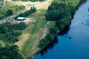
By: supercub185


