Login
Register


ACK
Nantucket Memorial Airport
Official FAA Data Effective 2026-02-19 0901Z
Chart Supplement

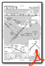
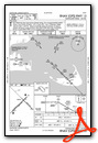
KACK Airport Diagram

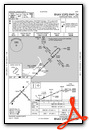
VFR Chart of KACK
Sectional Charts at SkyVector.com
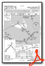
IFR Chart of KACK
Enroute Charts at SkyVector.com
Location Information for KACK
Coordinates: N41°15.20' / W70°3.63'Located 03 miles SE of Nantucket, Massachusetts on 1200 acres of land. View all Airports in Massachusetts.
Surveyed Elevation is 46 feet MSL.
Operations Data
|
|
Airport Communications
| ATIS: | 127.5 (508-228-5375) |
|---|---|
| ASOS: | Tel. 508-325-6082 |
| NANTUCKET TOWER: | 118.3 |
| NANTUCKET GROUND: | 132.5 |
| BOSTON APPROACH: | 126.1 318.1 |
| BOSTON DEPARTURE: | 126.1 318.1 |
| CLEARANCE DELIVERY: | 119.375 |
| EMERG: | 121.5 243.0 |
| DEEPO STAR: | 133.75 |
| CTAF: | 118.300 |
| UNICOM: | 122.950 |
| ASOS at CQX (26.3 N): | 135.875 508-945-5034 |
| ATIS at MVY (26.3 W): | 126.25 |
| ASOS at MVY (26.4 W): | 126.25 508-696-6988 |
Nearby Navigation Aids
|
| ||||||||||||||||||||||||||||||||||||||||||||||||||||||


Runway 06/24
| Dimensions: | 6303 x 150 feet / 1921 x 46 meters | |
|---|---|---|
| Surface: | Asphalt / Grooved in Good Condition | |
| Weight Limits: | S-75, D-170, ST-280
PCR VALUE: 770/F/A/X/T
| |
| Edge Lighting: | High Intensity | |
| Runway 06 | Runway 24 | |
| Coordinates: | N41°14.82' / W70°4.35' | N41°15.55' / W70°3.38' |
| Elevation: | 24.8 | 46.7 |
| Traffic Pattern: | Left | Left |
| Runway Heading: | 45° True | 225° True |
| Displaced Threshold: | 538 Feet | |
| Declared Distances: | TORA:6303 TODA:6303 ASDA:6303 LDA:5765 | TORA:6303 TODA:6303 ASDA:6303 LDA:6303 |
| Markings: | Precision Instrument in good condition. | Precision Instrument in good condition. |
| Glide Slope Indicator | P4R (3.00° Glide Path Angle) | P4L (3.00° Glide Path Angle) |
| RVR Equipment | Touchdown Rollout | Touchdown Rollout |
| Approach Lights: | MALSF 1,400 Foot Medium-intensity Approach Lighting System with sequenced flashers. | SSALR Simplified Short Approach Lighting System with runway alignment indicator lights. SSALR UNMON WHEN TWR CLSD. |
| Centerline Lights: | Yes | Yes |
Runway 15/33
| Dimensions: | 4500 x 100 feet / 1372 x 30 meters | |
|---|---|---|
| Surface: | Asphalt / Grooved in Good Condition | |
| Weight Limits: | S-60, D-85, ST-155
PCR VALUE: 430/F/A/X/T
| |
| Edge Lighting: | Medium Intensity | |
| Runway 15 | Runway 33 | |
| Coordinates: | N41°15.48' / W70°3.65' | N41°14.96' / W70°2.96' |
| Elevation: | 45.2 | 40.5 |
| Traffic Pattern: | Left | Left |
| Runway Heading: | 135° True | 315° True |
| Declared Distances: | TORA:4500 TODA:4500 ASDA:4500 LDA:4500 | TORA:4500 TODA:4500 ASDA:4500 LDA:4500 |
| Markings: | Non-Precision Instrument in good condition. | Non-Precision Instrument in good condition. |
| Glide Slope Indicator | P4L (3.00° Glide Path Angle) | |
| REIL: | Yes | Yes |
| Obstacles: | 30 ft Building 800 ft from runway, 280 ft left of center | |
Services Available
| Fuel: | 100LL (blue), Jet-A |
|---|---|
| Transient Storage: | Hangars,Tiedowns |
| Airframe Repair: | NONE |
| Engine Repair: | NONE |
| Bottled Oxygen: | NONE |
| Bulk Oxygen: | NONE |
| Other Services: | AIR FREIGHT SERVICES,CHARTER SERVICE |
Ownership Information
| Ownership: | Publicly owned | |
|---|---|---|
| Owner: | TOWN OF NANTUCKET | |
| SELECTMAN'S OFFICE | ||
| NANTUCKET, MA 02554 | ||
| Manager: | WARREN SMITH | |
| 14 AIRPORT RD | ||
| NANTUCKET, MA 02554 | ||
| 508-325-7531 | ||
Other Remarks
- BE AWARE OF HIGH-SPD MIL JET & HVY HEL TFC VCNTY AIR STATION CAPE COD.
- TWY F RSTRD TO SML ACFT 12500 LBS OR LESS.
- TXL F BTN TWY B & TWY H CLSD TO ACFT WITH WINGSPAN MORE THAN 79FT.
- ARPT HAS NOISE ABATEMENT PROCS CTC NOISE OFFICER 508-325-5300.
- DEER & BIRDS ON & INVOF ARPT.
- FOR CD IF TWR CLSD & UNA TO CTC FSS FREQ, CTC BOSTON APCH AT 603-594-5554.
- WHEN ATCT CLSD ACTVT MALSF RWY 06; SSALR RWY 24; HIRL RWY 06/24; MIRL RWY 15/33; TWY LGTS - CTAF. PAPI RWY 06, 24 & 33 OPR 24 HRS.
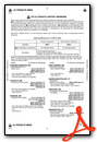
Weather Minimums

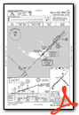
Standard Terminal Arrival (STAR) Charts

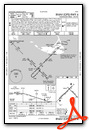
Instrument Approach Procedure (IAP) Charts


Nearby Airports with Instrument Procedures
| ID | Name | Heading / Distance | ||
|---|---|---|---|---|
 |
KCQX | Chatham Municipal Airport | 006° | 26.3 |
|
KMVY | Martha's Vineyard Airport | 288° | 26.4 |
|
KHYA | Cape Cod Gateway Airport | 338° | 26.8 |
|
5B6 | Falmouth Airpark Airport | 312° | 29.4 |
|
KFMH | Cape Cod Coast Guard Air Station Airport | 319° | 32.1 |
|
KEWB | New Bedford Regional Airport | 302° | 47.8 |
|
KPYM | Plymouth Municipal Airport | 322° | 49.5 |
|
KPVC | Provincetown Municipal Airport | 351° | 49.6 |
|
KTAN | Taunton Municipal/King Field Airport | 311° | 56.9 |
|
KUUU | Newport State Airport | 287° | 57.6 |
|
KGHG | Marshfield Municipal - George Harlow Field Airport | 331° | 57.6 |
|
KOQU | Quonset State Airport | 289° | 64.4 |
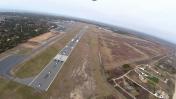
Airport Images

By: N1888E-young
By: N1888E-young


